
Hermine Moving Northeast
Hermine Moving Northeast
No Changes Tropical Storm Watches Warnings
European Model Adjusts Right


Based on overnight model runs there have been no important changes to the forecasts with regards to watches and warnings. Tropical Storm Warnings remain in effect for Coastal New Jersey southward with Tropical Storm Watches from New York City eastward including Southern Westchester, Coastal Connecticut and Long Island. Hermine is moving off the North Carolina Coast on schedule and should begin to organize an strengthen further offshore. It is also beginning to look more like a post tropical cyclone so it may be transitioning over to that status later today or tonight.
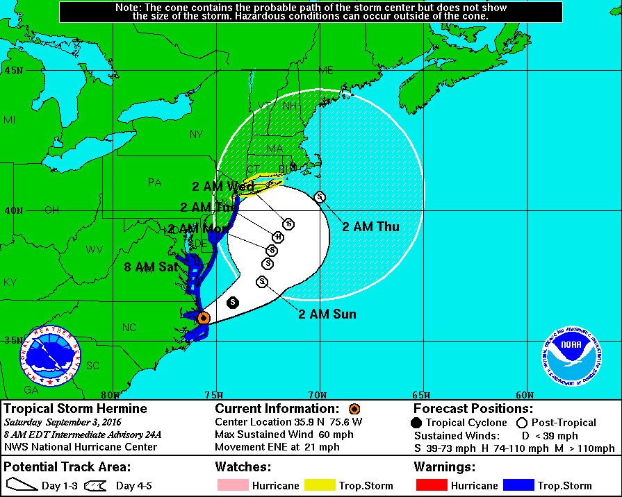
..HERMINE MOVING ACROSS THE NORTHERN OUTER BANKS OF NORTH
CAROLINA...
...WATER LEVELS RISING RAPIDLY IN THE HAMPTON ROADS AREA...


SUMMARY OF 800 AM EDT...1200 UTC...INFORMATION
----------------------------------------------
LOCATION...35.9N 75.6W
ABOUT 10 MI...15 KM NNW OF OREGON INLET NORTH CAROLINA
ABOUT 250 MI...40 KM SSE OF DUCK NORTH CAROLINA
MAXIMUM SUSTAINED WINDS...60 MPH...95 KM/H
PRESENT MOVEMENT...ENE OR 60 DEGREES AT 21 MPH...33 KM/H
MINIMUM CENTRAL PRESSURE...995 MB...29.38 INCHES


WATCHES AND WARNINGS
--------------------
CHANGES WITH THIS ADVISORY:

The Tropical Storm Warning has been discontinued south of Ocracoke
Inlet, North Carolina.

SUMMARY OF WATCHES AND WARNINGS IN EFFECT:

A Tropical Storm Warning is in effect for...
* Ocracoke Inlet to Sandy Hook
* Pamlico and Albemarle Sounds
* Chesapeake Bay from Drum Point southward
* Tidal Potomac from Cobb Island eastward
* Delaware Bay

A Tropical Storm Watch is in effect for...
* North of Sandy Hook to west of Watch Hill

Interests elsewhere along the United States northeast coast should
monitor the progress of this system.  Additional watches or warnings
may be required for portions of this area later today.

For storm information specific to your area, including possible
inland watches and warnings, please monitor products issued by your
local National Weather Service forecast office.


DISCUSSION AND 48-HOUR OUTLOOK
------------------------------
At 800 AM EDT (1200 UTC), the center of Tropical Storm Hermine was
located by NOAA Doppler radar and surface observations near the
northern Outer Banks of North Carolina near latitude 35.9 North,
longitude 75.6 West.  Hermine is moving toward the east-northeast
near 21 mph (33 km/h), and this general motion with a decrease in
forward speed is forecast to continue today.  A gradual turn toward
the north is expected on Sunday.  On the forecast track, the center
of Hermine will emerge over the Atlantic very soon, and then slow
down and meander offshore of the Delmarva Peninsula tonight and
Sunday.

Maximum sustained winds remain near 60 mph (95 km/h) with higher
gusts.  Strengthening is forecast after the center moves over water,
and Hermine could be near hurricane intensity by Sunday.

Tropical-storm-force winds extend outward up to 185 miles (295 km)
mainly to the south and east of the center.  Elizabeth City, North
Carolina, recently reported a sustained wind of 32 mph (52 km/h) and
a wind gust of 52 mph (83 km/h).  A National Ocean Service station
at Rappahannock Light, Virginia, recently reported a sustained wind
of 40 mph (64 km/h), and a wind gust of 45 mph (72 km/h).

The estimated minimum central pressure based on surface observations
is 995 mb (29.38 inches).  A National Ocean Service station at
Oregon Inlet Marina, North Carolina, recently reported a pressure
of 996.6 mb (29.41 inches).
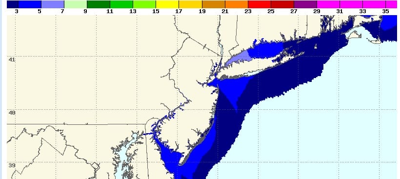
Based on the latest National Hurricane Center’s forecast track the storm surge forecast into the Sunday night high tide will be 3 to 5 feet up and down the coast from New Jersey to Long Island with 5 to 7 feet forecast for Long Island Sound.
The overnight European model shifted its track to the right and keeps Hermine moving just offshore doing the loop and jog westward. Middle runs continue that idea with a slight trend eastward and the slowly drift it out to the north and northeast during the early part of next week. This will bring several flooding tide cycles. We are going to now see what the day runs do which begin shortly.
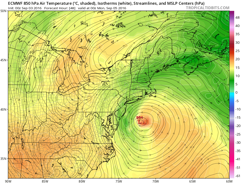
The European brings this back westward Sunday night but it is about 75 miles further east then yesterday’s day run. I think the idea of the the track hook back is correct and now it is just a matter of letting it play out. The European would bring gales and rain to the coast from New Jersey to Long Island Sunday and Sunday night into Monday morning but keep the severe storm surge high tide scenario from happening.
FiOS1 News Weather Forecast For Long Island
FiOS1 News Weather Forecast For New Jersey
FiOS1 News Weather Forecast For Hudson Valley
NATIONAL WEATHER SERVICE SNOW FORECASTS
LATEST JOESTRADAMUS ON THE LONG RANGE
Weather App

Don’t be without Meteorologist Joe Cioffi’s weather app. It is really a meteorologist app because you get my forecasts and my analysis and not some automated computer generated forecast based on the GFS model. This is why your app forecast changes every 6 hours. It is model driven with no human input at all. It gives you an icon, a temperature and no insight whatsoever.
It is a complete weather app to suit your forecast needs. All the weather information you need is right on your phone. Android or I-phone, use it to keep track of all the latest weather information and forecasts. This weather app is also free of advertising so you don’t have to worry about security issues with your device. An accurate forecast and no worries that your device is being compromised.
Use it in conjunction with my website and my facebook and twitter and you have complete weather coverage of all the latest weather and the long range outlook. The website has been redone and upgraded. Its easy to use and everything is archived so you can see how well Joe does or doesn’t do when it comes to forecasts and outlooks.
Just click on the google play button or the apple store button on the sidebar for my app which is on My Weather Concierge. Download the app for free. Subscribe to my forecasts on an ad free environment for just 99 cents a month.
Get my forecasts in the palm of your hand for less than the cost of a cup of Joe!
![]()
![]()