
Heatwave Day 2 90 to 95 Degrees Monday
Heatwave Day 2 90 to 95 Degrees Monday
The first day of this “heatwave” saw temperatures hit the upper 80s to lower 90s this afternoon from South Central and Eastern Pennsylvania to New Jersey, Southeastern NY, Connecticut, and Long Island. The Long Island and Connecticut South Shore was the place to be with a nice sea breeze that came in early enough to keep temperatures in the 70s. That cooler air is working northward along shore locations. In New Jersey the west wind meant a hot beach with temperatures reaching 90 and a sea breeze only right along the immediate beaches late in the day. Skies are clear on the satellite and other than some clouds in the Northern Great Lakes moving northeast, the satellite loop is clean of cloud cover and skies should be nice and clear tonight with most lows in the 60s to near 70.
SATELLITE LOOP

REGIONAL RADAR

LOCAL RADAR NEW YORK CITY

LOCAL RADAR PHILADELPHIA


Radars are quiet and will remain so until late in the day Tuesday when a back door cold front moving southward could trigger off a thunderstorm. Highs both days will be 90 to 95 but it will be cooler at the shore.
HEATWAVE ENDS WEDNESDAY..FORECAST HIGH TEMPERATURES

THURSDAY FORECAST HIGH TEMPERATURES
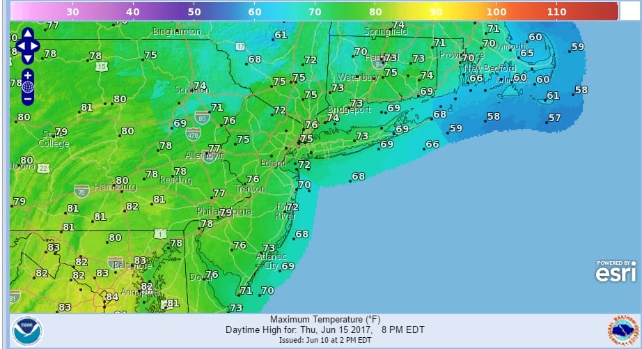
Wednesday & Thursday are still on course to be cooler with an onshore wind and temperatures some 10 to 15 degrees cooler. The next cold front will be coming for the Father’s day weekend and that could mean an increasing threat for showers and thunderstorms.
 GET JOE A CIGAR IF YOU LIKE

LANDSCAPE COMPANIES FOR YOUR NEEDS
LONG ISLAND ROCKLAND COUNTY Connecticut

![]()

ROCKLAND COUNTY TRI STATE SNOW REMOVAL JOHNSTOWN PA


FiOS1 News Weather Forecast For Long Island
FiOS1 News Weather Forecast For New Jersey
FiOS1 News Weather Forecast For Hudson Valley
NATIONAL WEATHER SERVICE SNOW FORECASTS
LATEST JOESTRADAMUS ON THE LONG RANGE
Weather App

Don’t be without Meteorologist Joe Cioffi’s weather app. It is really a meteorologist app because you get my forecasts and my analysis and not some automated computer generated forecast based on the GFS model. This is why your app forecast changes every 6 hours. It is model driven with no human input at all. It gives you an icon, a temperature and no insight whatsoever.
It is a complete weather app to suit your forecast needs. All the weather information you need is right on your phone. Android or I-phone, use it to keep track of all the latest weather information and forecasts. This weather app is also free of advertising so you don’t have to worry about security issues with your device. An accurate forecast and no worries that your device is being compromised.
Use it in conjunction with my website and my facebook and twitter and you have complete weather coverage of all the latest weather and the long range outlook. The website has been redone and upgraded. Its easy to use and everything is archived so you can see how well Joe does or doesn’t do when it comes to forecasts and outlooks.
Just click on the google play button or the apple store button on the sidebar for my app which is on My Weather Concierge. Download the app for free. Subscribe to my forecasts on an ad free environment for just 99 cents a month.
Get my forecasts in the palm of your hand for less than the cost of a cup of Joe!


