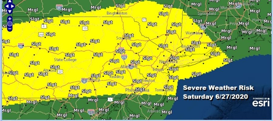
Heat Humidity Expanded Severe Weather Risk Saturday

We have arrived at the end of another week and we are going to see a beautiful day today with lots of sunshine, very warm temperatures in the mid to upper 80s but the humidity will remain reasonable. However everything changes on Saturday as very humid air arrives with a warm front going by Saturday morning, temperatures that will reach the upper 80s and lower 90s. Add an upper trough and a weather front approaching and we have severe weather risk. The Storm Prediction Center has expanded the risk area for severe weather further south in New Jersey and Southeast Pennsylvania (slight risk) and also further east and northeast to cover Long Island, much of Connecticut and back westward into the Hudson Valley and the Catskills as well as almost all of Pennsylvania.
SATELLITE

REGIONAL RADAR

The satellite and radar are not showing much. Just a few patchy clouds are left on the satellite picture this morning and most of the area is enjoying sunshine while the regional radar is quiet as well with nothing more than an isolated pop up shower or thunderstorm expected in areas well inland.

Most of tonight will be dry before a warm front comes through Saturday morning early and there could be a downpour or a thunderstorm when the warm front goes by. The best chances will be as you head north. Then the heat and humidity are turned on with soaring dew points and temperatures reaching the upper 80s and lower 90s.
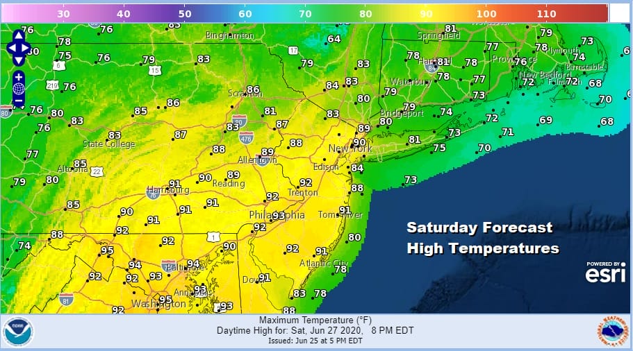
It is an east west frontal boundary that will be moving southward which cuts off cool ocean air and thunderstorms will hold together as a line likely develops and moves southeast from Upstate NY and Western New England. Timing will be during the evening hours so much of Saturday should be fine other than an isolated pop up shower or thunderstorm that could develop in the steamy air mass. Sunday will be a very warm and still somewhat humid day with some sunshine and highs in the mid 80s to near 90. There is the chance for a pop up shower or thunderstorm in the afternoon mostly inland.

Next week brings a bit of a change as the jet stream in the Eastern US drops southward along the east coast and allows high pressure to build from the Eastern Great Lakes through New England. This sets up a cooler flow from the northeast beginning later Monday and then lasting into at least Thursday. The frontal boundary to the south should remain far enough south to spare us issues with widespread rain (though we certainly could use some) and keep things relatively dry this week. You will notice low pressure forms off the Carolinas and moves northward to Southeast New England midweek. It might be worth keeping a eye on this in case we see the boundary a little further west in the coming days but for now we will remain cautiously optimistic for next week. Temperatures will trend lower next week with highs in the mid to upper 80s Monday, low to mid 80s Tuesday, and upper 70s and lower 80s Wednesday. We remain mostly positive for the July 4th holiday weekend as we see no major issues developing.
BE SURE TO DOWNLOAD THE FREE METEOROLOGIST JOE CIOFFI WEATHER APP &
ANGRY BEN’S FREE WEATHER APP “THE ANGRY WEATHERMAN!
MANY THANKS TO TROPICAL TIDBITS FOR THE USE OF MAPS
Please note that with regards to any severe weather, tropical storms, or hurricanes, should a storm be threatening, please consult your local National Weather Service office or your local government officials about what action you should be taking to protect life and property.


