Florida Freezes Northeast Rebounds Early Call Snow Saturday Into Sunday
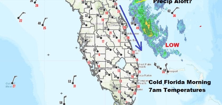
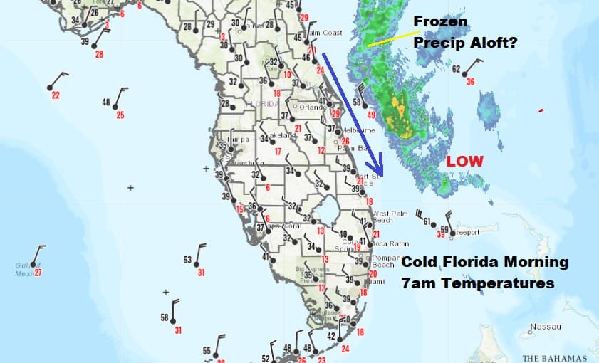
Anyone who has spent time in Florida knows that the residents there have coats, gloves, and scarfs on the minute the temperature drops below 70! This morning they are freezing down in Florida and while it is not unusual for it to get this cold in northern Florida it is in South Florida where temperatures this morning are in the 30s and in some cases down near 32. Wind chills are in the 20s and even the upper teens. To top it off there is a storm offshore and the air aloft is cold enough that we could be seeing some frozen precip on the radar!
Meanwhile we are set for a rebound in temperatures here today as everyone goes above freezing! Skies are nice and clear on the satellite this morning from the northeast all the way west and south into the Ohio and Tennessee Valley. From our lows in the teens to mid 20s we should reach mid 30s to lower 40s in some places this afternoon with sunshine pretty much from start to finish.
SATELLITE

REGIONAL RADAR

There are no weather issues here probably through the daytime Friday. Tonight will be nice and clear with lows not as cold..20s to near 30. Sunshine for Thursday & Sun and arriving clouds on Friday should take highs into the low and mid 40s both days.

Nothing much has changed overnight regarding Saturday into Sunday morning as low pressure coming out of the Mississippi Valley heads to the lower lakes and a secondary low forms in the Western Carolinas and moves northeast.

This is going to be a raw rainy Saturday for areas from Southern Pennsylvania northeastward to Southern New England with elevation driven snows across Central and Northern Pennsylvania northeast to the Catskills and interior New England. I didn’t change anything yet regarding my early snow forecast call from yesterday. It is a general idea on how things will play out. There is a chance we could see accumulating snow into Northwest New Jersey and parts of Orange & Sullivan counties out of this either at the onset or when the system is winding down Sunday morning. The low tracks literally right on the coast and the minimal amount of cold air prevent this from being anything other than rain for the I-95 urban corridor while we will watch what happens inland and especially above 1500 ft of elevation. Weather conditions will improve later Sunday and next week starts of dry and calm.
BE SURE TO DOWNLOAD THE FREE METEOROLOGIST JOE CIOFFI WEATHER APP &
ANGRY BEN’S FREE WEATHER APP “THE ANGRY WEATHERMAN!
MANY THANKS TO TROPICAL TIDBITS FOR THE USE OF MAPS
Please note that with regards to any severe weather, tropical storms, or hurricanes, should a storm be threatening, please consult your local National Weather Service office or your local government officials about what action you should be taking to protect life and property.


