
FLORENCE FLOODING REMNANT LOW MOVING NORTHEASTWARD
RAINS HEADING INTO PENNSYLVANIA FLOOD WATCHES POSTED
SUMMARY OF 500 AM EDT…0900 UTC…INFORMATION
———————————————-
LOCATION…36.9N 82.2W
ABOUT 125 MI…200 KM WSW OF ROANOKE VIRGINIA
ABOUT 145 MI…230 KM WNW OF GREENSBORO NORTH CAROLINA
MAXIMUM SUSTAINED WINDS…30 MPH…45 KM/H
PRESENT MOVEMENT…NNE OR 20 DEGREES AT 13 MPH…20 KM/H
MINIMUM CENTRAL PRESSURE…1008 MB…29.77 INCHES
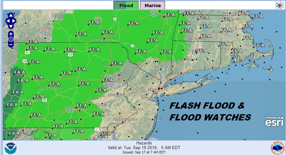
The remnant low of Florence continues to move out of North Carolina though some bands of rain remain there today. Flood Watches and Flash Flood Watches have been posted for much of Pennsylvania and parts of New York State into New England. When you look at where the flood watches are posted, it is telling us that the surface low will be passing to our north. While this doesn’t mean we won’t see some heavy downpours, the heaviest rains are going to be north and west of the coast.
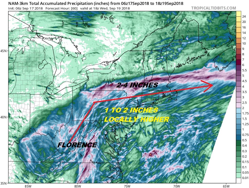
Looking at various models this morning we think the NAM 3 model probably makes the most sense with a 2 to 4 inch band of rain across upstate NY where they will be north of the surface low while to the south an inch or 2 is possible with more variability. The rain is not going to be continuous. It looks like there will be one solid shot during the day on Tuesday that puts this down in a hurry from Eastern Pennsylvania to Southern New England with scattered stuff around the rest of the time.
EASTERN SATELLITE

REGIONAL RADAR

Now that the remnant low has moved far enough northward we are seeing the arm of rain lifting northeastward through Virginia and approaching Maryland and Western Pennsylvania. The eastern extent of that arm will extend across Eastern Pennsylvania and western New Jersey late today with a few showers going into the evening. Local radars this morning are quiet but we will start seeing some radar echos show up later this morning and this afternoon.
LOCAL RADAR NEW YORK CITY

LOCAL RADAR PHILADELPHIA


For the rest of the day any sunshine this morning gives way to arriving clouds. Then some showers will be around west of the coast late this afternoon and evening. There will be some showers around overnight into Tuesday followed by one solid shot of downpours and possible thunderstorms later Tuesday morning into the late afternoon and evening. Temperatures will be in the 70s today and upper 70s and lower 80s on Tuesday. Weather conditions will improve on Wednesday with some sunshine and lower humidity with highs in the 70s.
MANY THANKS TO TROPICAL TIDBITS FOR THE USE OF MAPS
Please note that with regards to any tropical storms or hurricanes, should a storm be threatening, please consult your local National Weather Service office or your local government officials about what action you should be taking to protect life and property.
LATEST JOESTRADAMUS ON THE LONG RANGE


