FLORENCE BEGINS TO MOVE MORE TO THE NORTH
RAINS SPREADING INTO WESTERN VA & WVA
REMNANT FLORENCE ARRIVES PA/NY/NJ/PA LATE MONDAY TUESDAY
SUMMARY OF 500 PM EDT…2100 UTC…INFORMATION
———————————————-
LOCATION…34.6N 82.2W
ABOUT 25 MI…40 KM SSE OF GREENVILLE SOUTH CAROLINA
ABOUT 60 MI…95 KM SSE OF ASHEVILLE NORTH CAROLINA
MAXIMUM SUSTAINED WINDS…35 MPH…55 KM/H
PRESENT MOVEMENT…N OR 350 DEGREES AT 14 MPH…22 KM/H
MINIMUM CENTRAL PRESSURE…1006 MB…29.71 INCHES
The Blacksburg Virginia radar now become the focal point for the rains from Florence. Florence is now a tropical depression but the rains continue. Florence is moving northward at 14 mph which the fastest rate of speed we have since last Wednesday before making landfall. Rains of up to 6 inches are possible in Western Virginia and Eastern West Virginia with locally higher amounts likely. This area has see up to 600% of their normal summer rainfall and another half a foot means flooding is likely to develop in a hurry. All of this will continue to move northward Monday as the rain moves into Western and Central Pennsylvania and then over New Jersey Southern NY Long Island and Connecticut for Monday night and Tuesday. It won’t be a non stop rain as it is likely to come in waves. We will see a much weaker version of this but we need to watch the surviving circulation and whether it remains intact. Right now we are thinking a 1 to 2 or 3 inch rainfall is possible with some variability which in general should be manageable but be alert to some locally higher amounts and some local flash flooding if the circulation survives the trip up the Appalachians and the the turn to the northeast toward us,

EASTERN SATELLITE

Meanwhile it was a gorgeous late summer day here. It was somewhat humid but not overly so. Temperatures reached into the 80s. Folks flocked to the beaches where the seas were a bit calmer but still rather active. Skies will be clear tonight with northern fringe Florence clouds coming on the scene overnight at times and lows mostly in the 60s to near 70. Local radars remain quiet and there are no issues into Monday afternoon.
REGIONAL RADAR

Clouds increase and the humidity goes up on Monday as the broadening circulation of Florence comes in play. Temperatures will be in the 70s to near 80. Areas from Northern New Jersey west could see some showers late Monday afternoon and evening in the increasingly tropical air mass allows for some showers to develop but they should be scattered and light. Late Monday night and Tuesday we will see some bands of heavier downpours approaching and moving through with mid morning to early evening being the greatest risk time.
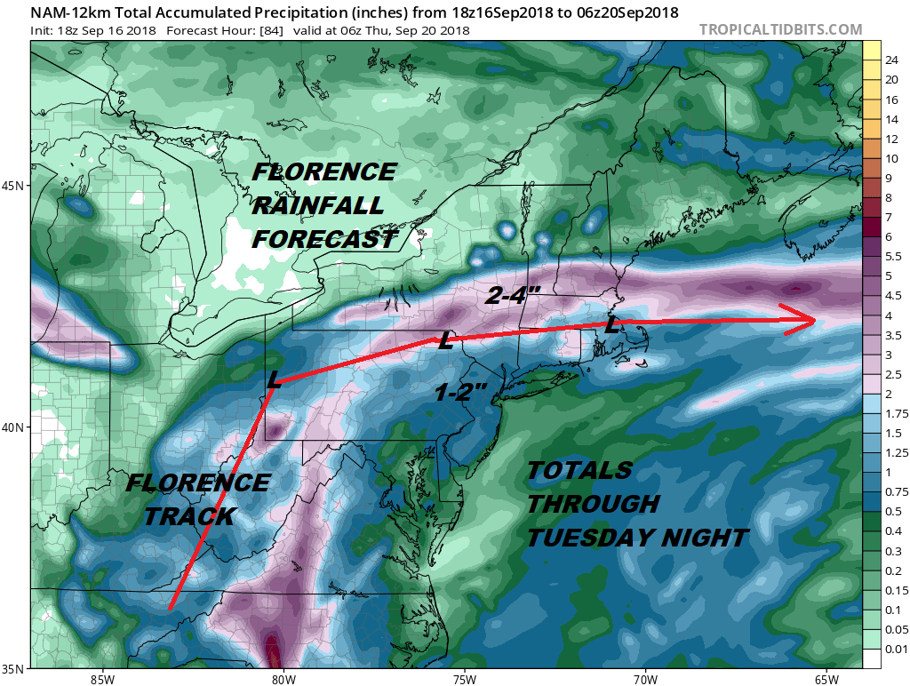
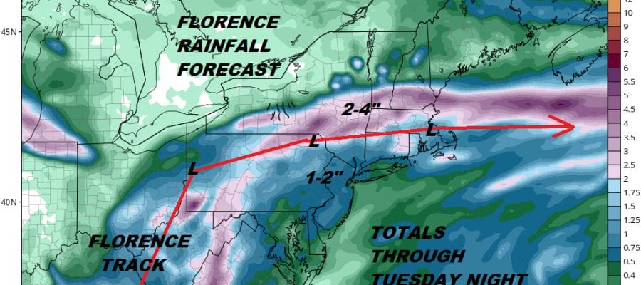
Trying to figure out total rainfalls with tropical systems is always tricky. The track of the NAM for example shows the heaviest rain north and west of the coast with 2 to 4 inch rains across upstate NY. A further south track would be more problematic with rain fall amounts. 1 to 2 inch rains seem to a minimum here but it would not be a huge shock to see higher amount come into play. Right now the Storm Prediction Center has no risk for severe weather but I would not be shocked to see a marginal risk area appear by the time we get to Tuesday.
Weather conditions improve on Wednesday behind this with sunshine and lower humidity returning. Highs will be in the 70s. Thursday looks like a good day before the next cold front begins to approach at the end of the week.
MANY THANKS TO TROPICAL TIDBITS FOR THE USE OF MAPS
Please note that with regards to any tropical storms or hurricanes, should a storm be threatening, please consult your local National Weather Service office or your local government officials about what action you should be taking to protect life and property.
LATEST JOESTRADAMUS ON THE LONG RANGE


