HEAT HUMIDITY MOVING IN MONDAY LASTING THROUGH THURSDAY
OUTSIDE CHANCE DOWNPOUR OR A THUNDERSTORM
WEATHER FRONT APPROACHES LATE THURSDAY,
ONSHORE FLOW AGAIN NEXT WEEKEND
We begin the second day of this holiday weekend with a bit more onshore flow impact. At least this keeps the oppressive heat humidity at bay for another 24 hours. We are going to see another day of mostly cloudy skies, a wind off the ocean, and temperatures that will be in the upper 70s to lower 80s. Later today some areas could see some downpours or thunderstorms pop up. Much of the time today it will be dry so go ahead and plan your outdoor activities accordingly.
REGIONAL RADAR

There isn’t much yet on the regional and local radars this morning though some scattered showers are showing up on the Philadelphia radar below. Most of what is out there this morning is on the light side.
LOCAL RADAR NEW YORK CITY

LOCAL RADAR PHILADELPHIA


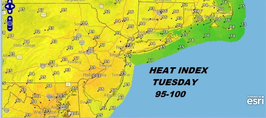
Monday begins a 4 day stretch of heat humidity and the risk for a late day pop up downpour or thunderstorm but those will be few and far between. Monday’s highs will be in the upper 80s to lower 90s. Tuesday looks to be the hottest day of the stretch with highs reaching 90 to 95. Wednesday and Thursday we will see upper 80s to lower 90s.

Finally late Thursday a cold front approaches with a break coming in the heat and humidity Friday but it sets up almost the same way as what we went through this weekend. The difference this time is that we may have more showers with the front stalled to our south Friday into next weekend. That is a worry for later on this week. In the meantime we are all still in holiday mode trying to enjoy the last days of summer vacation so make the best of the weather the next 2 days.
MANY THANKS TO TROPICAL TIDBITS FOR THE USE OF MAPS
Please note that with regards to any tropical storms or hurricanes, should a storm be threatening, please consult your local National Weather Service office or your local government officials about what action you should be taking to protect life and property.
LATEST JOESTRADAMUS ON THE LONG RANGE


