FLORENCE 60 MPH STILL IN FAR EASTERN ATLANTIC
TROPICAL WAVE HEADING FOR EASTERN GULF OF MEXICO
DEPRESSION COULD FORM NEXT SEVERAL DAYS
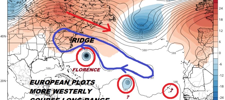
Tropical Storm Florence continues to move along to the west though rather slowly and it continues to gain some strength with top winds of 60 mph. It is moving west at 15 mph and still is far out in the Eastern Atlantic. The satellite presentation remains good as the system has developed a concentrated core of convection. Upper air winds remain favorable going forward. Ocean water temperatures in this part of the Atlantic are supportive only to a point. Warmer water lies to the west once Florence gets west of 45 degrees west but then upper level winds will constrain it somewhat.

Florence will have two opportunities to respond to upper level winds that could turn it to the north. The problem with this scenario is that the system will remain relatively weak..that is it is unlikely to strengthen to a hurricane anytime soon. If Florence remains a tropical storm it will more than likely respond to the lower level steering winds which means a more westerly course in the longer term. The European model has been very consistent on this view and carries Florence west or west north west through much of its 10 day forecast period. The GFS turns Florence northward due to it developing Florence into a major hurricane (which is likely to be overdeveloped).
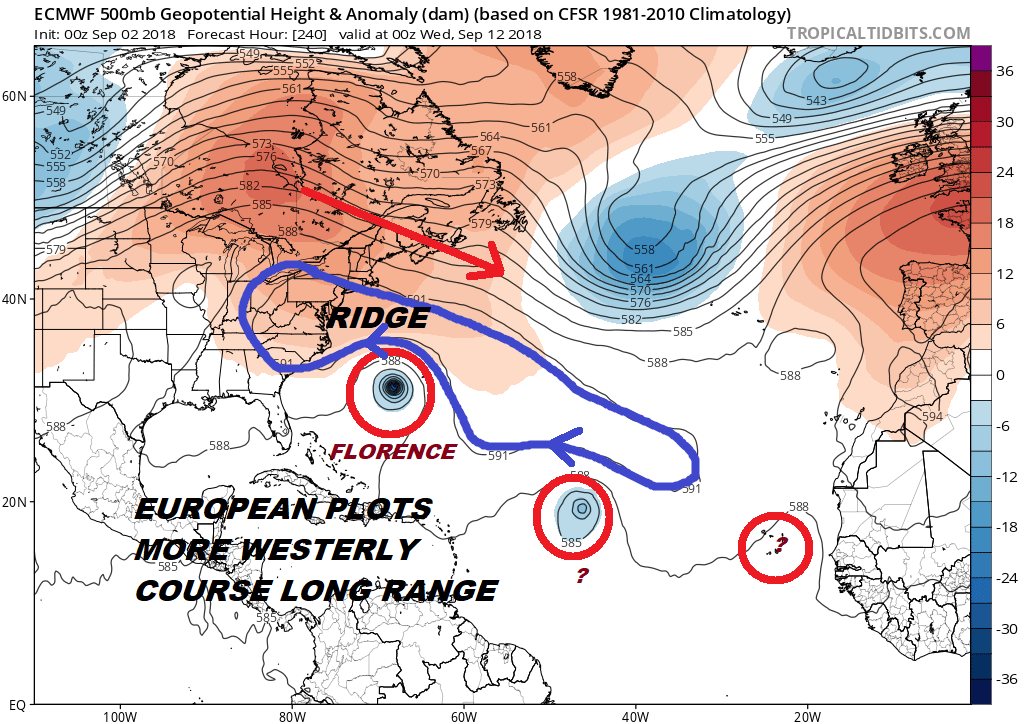
The European also has a different view of the upper air profile off the East Coast and in the Atlantic. The model continues to maintain a persistent ridge in the East where Florence misses recurving opportunities along its track. The GFS has been guilty of overdeveloping troughs both in the Atlantic and across the US for the last few weeks and we see no reason for that trend not to continue. For now however we are talking in purely speculative watch and see mode. Also note the European as are the other model show a very active tropical period continuing for the next 2 weeks.
WIDE ATLANTIC TROPICAL SATELLITE

Meanwhile closer to home we continue to watch a tropical wave moving westward across Cuba, the Bahamas and Florida today into Monday as it heads into the Eastern Gulf of Mexico. Upper air winds will become more favorable on Monday when the system enters the Eastern Gulf of Mexico and a tropical depression is likely to form over the next several days. This is going to produce heavy rains across the Bahamas and South Florida and eventually the Central Gulf Coast later this week so obviously we have another system to watch here as we move into the new week.
With regards to the week ahead local forecast JOESTRADAMUS has the latest.
Please consult your local National Weather Service office at weather.gov for the latest information on any tropical or storms or hurricanes that could be a threat to your area. Consult your local government officials regarding action you may need to take to secure life and property
FiOS1 News Weather Forecast For Long Island
FiOS1 News Weather Forecast For New Jersey
FiOS1 News Weather Forecast For Hudson Valley