Cool July Weather Through Wednesday
Cool July Weather Through Wednesday
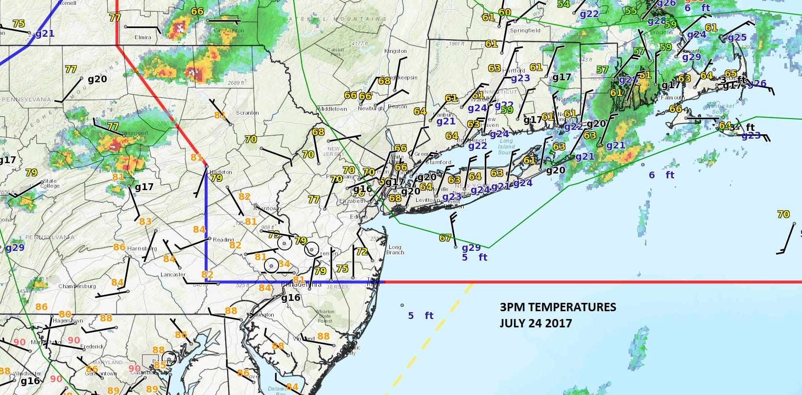
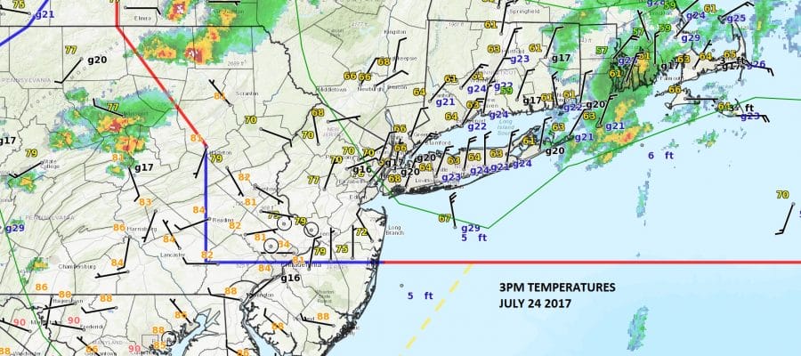
For much of the area cool July weather has taken over thanks to a northeast to north wind. Temperatures north of the frontal boundary that runs through Central New Jersey are in the 60s to lower 70s while South Jersey and Eastern Pennsylvania west of the Poconos are in the 80s. Some thunderstorms are showing up on the radar and they are moving east but it is doubtful that they will survive once they enter into the cool air north of the frontal boundary. The Storm Prediction Center has indicated that a severe thunderstorm watch is unlikely.
SATELLITE LOOP

REGIONAL RADAR

LOCAL RADAR NEW YORK CITY

LOCAL RADAR PHILADELPHIA


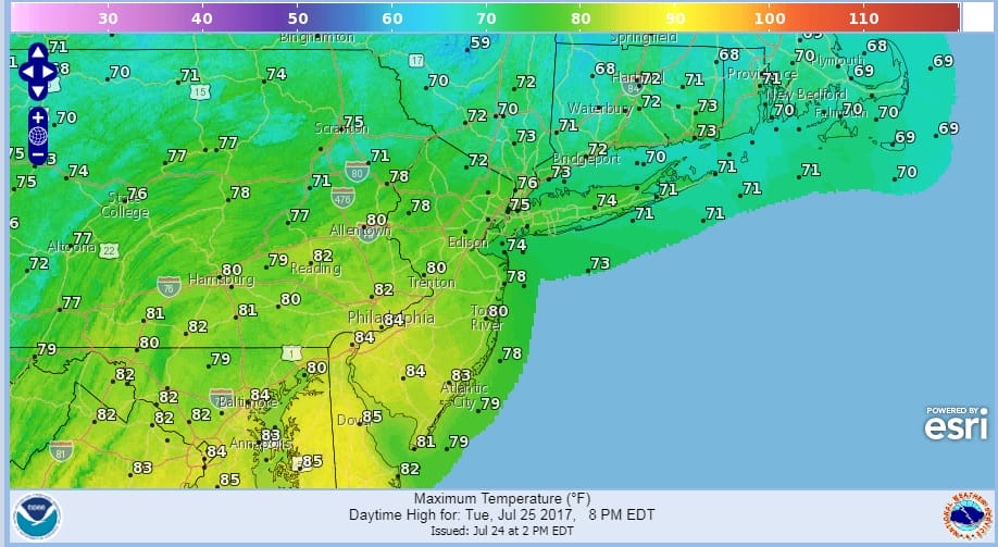
Cool July weather will be with us for the next 2 days. Tuesday there will be cloud issues and along the coast some spotty light rain or drizzle is possible tonight into Tuesday morning. Dry air from New England will gradually work its way southward Tuesday afternoon and some breaks of sun could develop and spread northeast to southwest later Tuesday afternoon but it may be a close call. The clearing may hold off until evening. Temperatures Tuesday will be in the 70s except warmer in South Jersey & Southeastern Pennsylvania.
COOL JULY WEATHER TUESDAY’S HIGHS
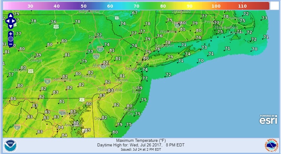
Wednesday will be a nice pleasant day with highs mostly in the 70s with some spots reaching 80 with low humidity.
COOL JULY WEATHER WEDNESDAY’S HIGHS
Thursday we will be back in the 80s with the humidity coming up ahead of the next cold front which comes through Thursday night with a shower or thunderstorm. Friday through Sunday will hinge on how that front stalls out and where. If it is far enough south the weather should be nice right through but right now i’m a little cautious especially for Saturday.
 GET JOE A CIGAR IF YOU LIKE

LANDSCAPE COMPANIES FOR YOUR NEEDS
LONG ISLAND ROCKLAND COUNTY Connecticut

![]()

ROCKLAND COUNTY TRI STATE SNOW REMOVAL JOHNSTOWN PA


FiOS1 News Weather Forecast For Long Island
FiOS1 News Weather Forecast For New Jersey
FiOS1 News Weather Forecast For Hudson Valley
NATIONAL WEATHER SERVICE SNOW FORECASTS
LATEST JOESTRADAMUS ON THE LONG RANGE
Weather App

Don’t be without Meteorologist Joe Cioffi’s weather app. It is really a meteorologist app because you get my forecasts and my analysis and not some automated computer generated forecast based on the GFS model. This is why your app forecast changes every 6 hours. It is model driven with no human input at all. It gives you an icon, a temperature and no insight whatsoever.
It is a complete weather app to suit your forecast needs. All the weather information you need is right on your phone. Android or I-phone, use it to keep track of all the latest weather information and forecasts. This weather app is also free of advertising so you don’t have to worry about security issues with your device. An accurate forecast and no worries that your device is being compromised.
Use it in conjunction with my website and my facebook and twitter and you have complete weather coverage of all the latest weather and the long range outlook. The website has been redone and upgraded. Its easy to use and everything is archived so you can see how well Joe does or doesn’t do when it comes to forecasts and outlooks.
Just click on the google play button or the apple store button on the sidebar for my app which is on My Weather Concierge. Download the app for free. Subscribe to my forecasts on an ad free environment for just 99 cents a month.
Get my forecasts in the palm of your hand for less than the cost of a cup of Joe!


