Autumn In July Through Saturday
Autumn In July Through Saturday
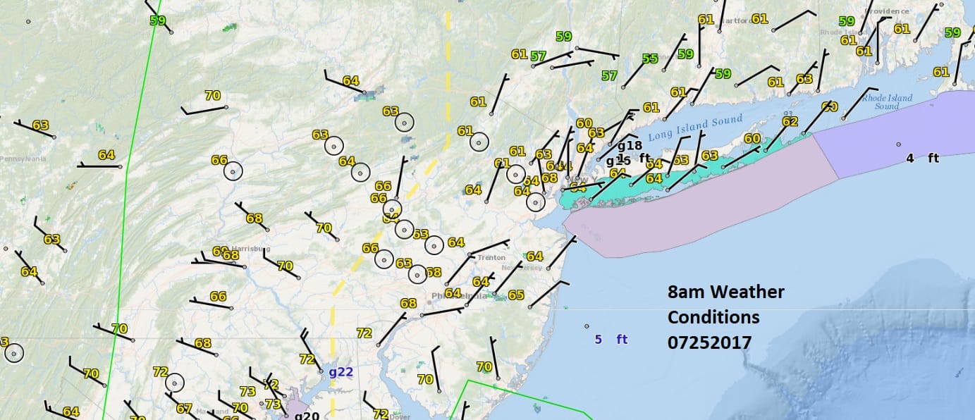
One look at the surface map above and you can get the sense that temperatures are a bit cool this morning with everyone in the 60s at 8am. This hasn’t happened in quite awhile. Lots of clouds everwhere plus a northeast wind and you have the setup for a cool day ahead. The lows aren’t far below the average but today’s highs will be as most areas will struggle back to the lower or middle 70s when we should be in the middle to upper 80s. This is also the warmest part of the year from mid July to the first week in August before average temperatures begin their decline.
SATELLITE LOOP

REGIONAL RADAR

LOCAL RADAR NEW YORK CITY

LOCAL RADAR PHILADELPHIA


Other than some spotty rain showers or some drizzle, this should be a quiet day with just a lot of clouds. The question is whether dry air makes it down from New England in time to at least brighten skies up late today. If not today certainly Wednesday looks like a great day with lots of sunshine and most area highs will be in the 70s.
AUTUMN IN JULY THURSDAY NIGHT INTO SATURDAY GFS MODEL
CLICK TO ANIMATE

Thursday it warms back into the 80s with an approaching cold front but this front is going to stall out Thursday night and a rather impressive wave on the front for this time of year at least will approach and move through on Friday. This will put us back in and onshore flow with rain and temperatures again probably confined to the 60s and 70s depending on location. If everything moves along the weekend promises improvement though it will be on the cool side.
 GET JOE A CIGAR IF YOU LIKE

LANDSCAPE COMPANIES FOR YOUR NEEDS
LONG ISLAND ROCKLAND COUNTY Connecticut

![]()

ROCKLAND COUNTY TRI STATE SNOW REMOVAL JOHNSTOWN PA


FiOS1 News Weather Forecast For Long Island
FiOS1 News Weather Forecast For New Jersey
FiOS1 News Weather Forecast For Hudson Valley
NATIONAL WEATHER SERVICE SNOW FORECASTS
LATEST JOESTRADAMUS ON THE LONG RANGE
Weather App

Don’t be without Meteorologist Joe Cioffi’s weather app. It is really a meteorologist app because you get my forecasts and my analysis and not some automated computer generated forecast based on the GFS model. This is why your app forecast changes every 6 hours. It is model driven with no human input at all. It gives you an icon, a temperature and no insight whatsoever.
It is a complete weather app to suit your forecast needs. All the weather information you need is right on your phone. Android or I-phone, use it to keep track of all the latest weather information and forecasts. This weather app is also free of advertising so you don’t have to worry about security issues with your device. An accurate forecast and no worries that your device is being compromised.
Use it in conjunction with my website and my facebook and twitter and you have complete weather coverage of all the latest weather and the long range outlook. The website has been redone and upgraded. Its easy to use and everything is archived so you can see how well Joe does or doesn’t do when it comes to forecasts and outlooks.
Just click on the google play button or the apple store button on the sidebar for my app which is on My Weather Concierge. Download the app for free. Subscribe to my forecasts on an ad free environment for just 99 cents a month.
Get my forecasts in the palm of your hand for less than the cost of a cup of Joe!


