Cold Start But Warmer Temps Showers Tuesday
Cold Start But Warmer Temps Showers Tuesday
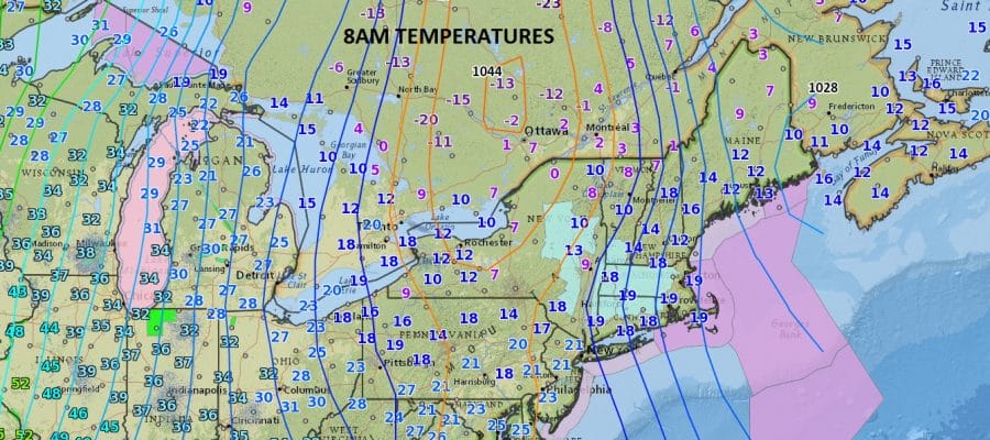
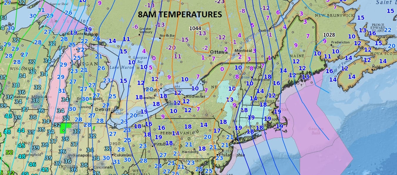
Nothing like waking up to a cold Sunday morning with a fireplace going and a hot cup of coffee though I will admit that this is a bit much. Temperatures bottomed in the low to mid teens in most places. The wind never really subsided much overnight which kept temperatures a bit higher than they other wise would be. We are headed for the 30s and most places should go above freezing this morning with lots of sunshine. Winds should drop off a bit inland as the center of the high passes and then a south wind begins. You can see on the map above the warmer temperatures already moving into the Midwest and that air is headed here over the next 2 days.
The satellite loop shows clear skies across the northeast with some high clouds moving into the Great Lakes. There are no issues regarding precipitation and radars will be nice and quiet.
SATELLITE LOOP

REGIONAL RADAR

Monday we will see sunshine give way to arriving clouds as temperatures make their way up through the 40s. Then we will see some showers and 50s on Tuesday as the next cold front approaches.

The dynamics with this cold front suggest that severe weather will not be an issue this time around. After this system goes by we will set up for a series of low pressure systems moving toward us. Some will try to go to our north and some will try to go to our south and there will be some cold air around at times so we will need to look at each system closely regarding whether it will be rain or snow or both. We will have more on this later today.
 GET JOE A CIGAR IF YOU LIKE

SNOW REMOVAL COMPANIES FOR YOUR WINTER NEEDS
LONG ISLAND ROCKLAND COUNTY Connecticut

![]()

ROCKLAND COUNTY TRI STATE SNOW REMOVAL JOHNSTOWN PA


FiOS1 News Weather Forecast For Long Island
FiOS1 News Weather Forecast For New Jersey
FiOS1 News Weather Forecast For Hudson Valley
NATIONAL WEATHER SERVICE SNOW FORECASTS
LATEST JOESTRADAMUS ON THE LONG RANGE
Weather App

Don’t be without Meteorologist Joe Cioffi’s weather app. It is really a meteorologist app because you get my forecasts and my analysis and not some automated computer generated forecast based on the GFS model. This is why your app forecast changes every 6 hours. It is model driven with no human input at all. It gives you an icon, a temperature and no insight whatsoever.
It is a complete weather app to suit your forecast needs. All the weather information you need is right on your phone. Android or I-phone, use it to keep track of all the latest weather information and forecasts. This weather app is also free of advertising so you don’t have to worry about security issues with your device. An accurate forecast and no worries that your device is being compromised.
Use it in conjunction with my website and my facebook and twitter and you have complete weather coverage of all the latest weather and the long range outlook. The website has been redone and upgraded. Its easy to use and everything is archived so you can see how well Joe does or doesn’t do when it comes to forecasts and outlooks.
Just click on the google play button or the apple store button on the sidebar for my app which is on My Weather Concierge. Download the app for free. Subscribe to my forecasts on an ad free environment for just 99 cents a month.
Get my forecasts in the palm of your hand for less than the cost of a cup of Joe!


