
Weather Models Blocking Troughing Battle Continues

Weather Models Blocking Troughing Battle Continues
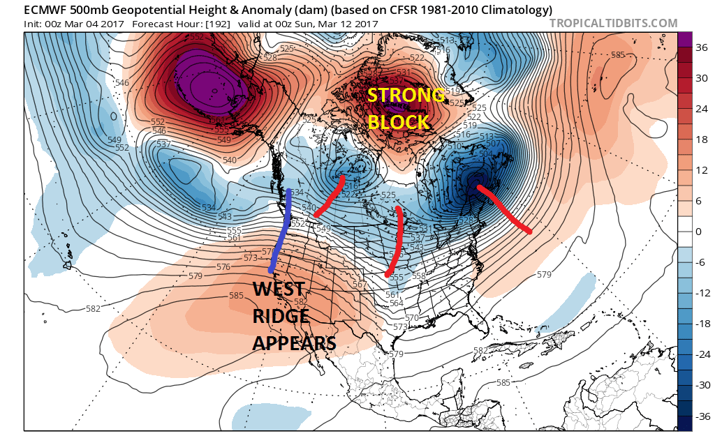
Last night’s weather model runs layed out 2 very distinct and opposite paths regarding the weather pattern for later this week complete with storm track implications for the East Coast. By now everyone knows about what the European model did with regards to developing a significant East Coast storm for next Sunday into Monday and by now everyone knows that the GFS did the exact opposite as it retains the general overall pattern we are in with little change. The video above illustrates in detail what last night’s model runs did and the factors in play. Today’s runs illustrate very well the issue and the two big questions at hand. The first is the blocking signature in the North Atlantic and the strength of that block which both models have. The second and more important key is in the west and the persistent unusually deep trough that has dominated the weather scene for much of the winter with only brief interruptions.
EUROPEAN OVERNIGHT MODEL RUN FOR SUNDAY EVENING 03122017
GFS WEATHER MODEL SUNDAY EVENING 03122017
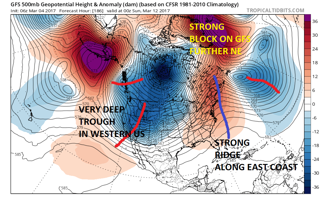
I have seen model differences over the years and some of them have been rather extreme but the differences last night were astounding between the two weather models. Positioning of the blocks are different. More importantly is the HUGE difference in the west. Where the European has so signs of a trough in the west and has a ridge there, the GFS weather model has a huge deep trough in the west. The same differences hold in the east only in reverse. The outcomes are essentially 2 different worlds.
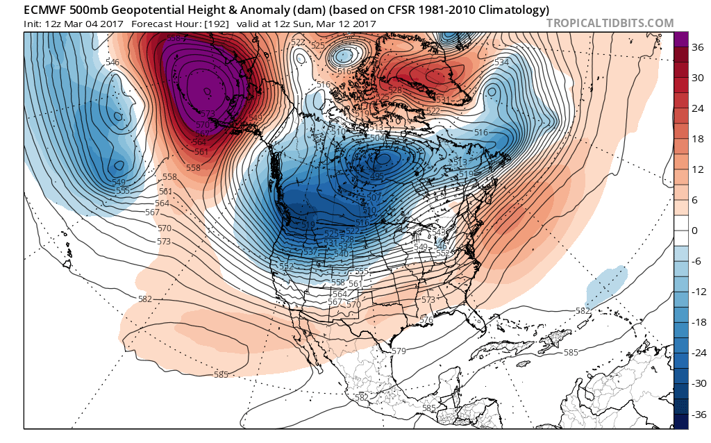
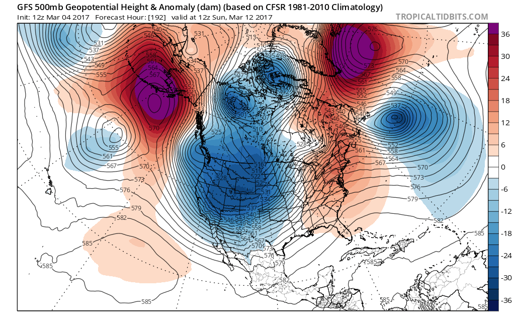
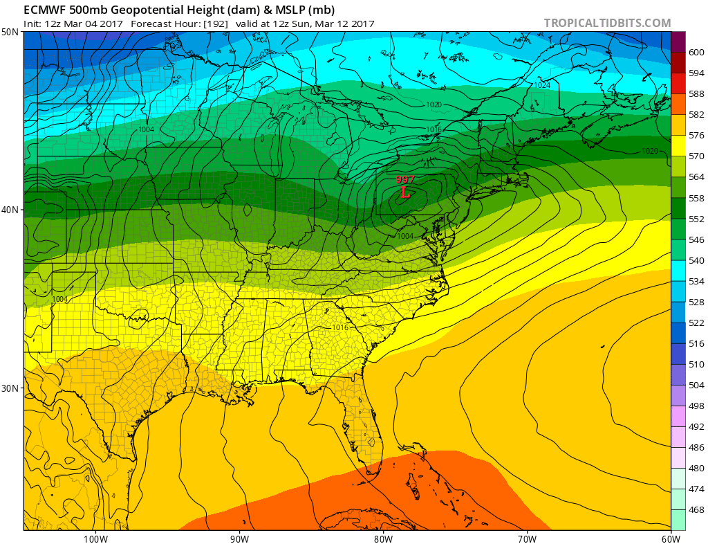
Today’s late morning model run has come a bit more in line and the GFS seems to have the upper hand. That model is virtually identical to its prior 2 runs with an extremely deep trough in the west. The European model this afternoon has partially caved to that idea though not nearly as deep. The European continues to show a system coming into the East next weekend but it is weaker, less dynamic and further north because the trough in the west creates a stronger ridge in the east and any systems that move into that can’t develop much. The result on today’s run verses last night’s run is a less deep further north low with no snow consequences except in Upstate NY and Central and Northern New England.
EUROPEAN SURFACE AND UPPER AIR FOR SUNDAY NIGHT INTO MONDAY 3/12-13/2017
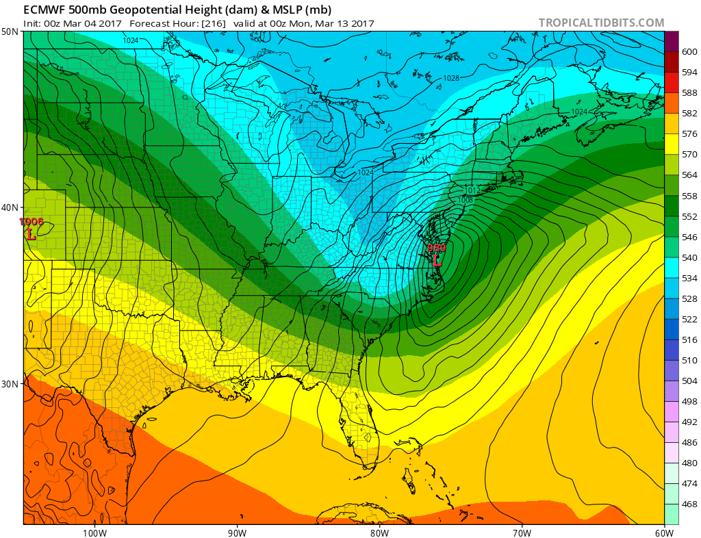
In the end the problem is a simple one. Is the trough in the west going to be as deep or deeper (more intense) than weather models are forecasting or will it be less intense and leave room for East Coast development. Weather patterns over the course of the winter rhyme and a betting person would see that the trend is your friend. The trough in the west has been persistent and dominant since December. Is there any reason to believe it is different this time?
MANY THANKS TO TROPICAL TIDBITS FOR THE WONDERFUL USE OF THE MAPS

GET JOE A CIGAR IF YOU LIKE!
SNOW REMOVAL COMPANIES FOR YOUR WINTER NEEDS
LONG ISLAND ROCKLAND COUNTY Connecticut

![]()

ROCKLAND COUNTY TRI STATE SNOW REMOVAL JOHNSTOWN PA


FiOS1 News Weather Forecast For Long Island
FiOS1 News Weather Forecast For New Jersey
FiOS1 News Weather Forecast For Hudson Valley
NATIONAL WEATHER SERVICE SNOW FORECASTS
LATEST JOESTRADAMUS ON THE LONG RANGE
Weather App

Don’t be without Meteorologist Joe Cioffi’s weather app. It is really a meteorologist app because you get my forecasts and my analysis and not some automated computer generated forecast based on the GFS model. This is why your app forecast changes every 6 hours. It is model driven with no human input at all. It gives you an icon, a temperature and no insight whatsoever.
It is a complete weather app to suit your forecast needs. All the weather information you need is right on your phone. Android or I-phone, use it to keep track of all the latest weather information and forecasts. This weather app is also free of advertising so you don’t have to worry about security issues with your device. An accurate forecast and no worries that your device is being compromised.
Use it in conjunction with my website and my facebook and twitter and you have complete weather coverage of all the latest weather and the long range outlook. The website has been redone and upgraded. Its easy to use and everything is archived so you can see how well Joe does or doesn’t do when it comes to forecasts and outlooks.
Just click on the google play button or the apple store button on the sidebar for my app which is on My Weather Concierge. Download the app for free. Subscribe to my forecasts on an ad free environment for just 99 cents a month.
Get my forecasts in the palm of your hand for less than the cost of a cup of Joe!
![]()
