Very Cold Night Ahead Warmer Weekend Long Range

Very Cold Night Ahead Warmer Weekend Long Range
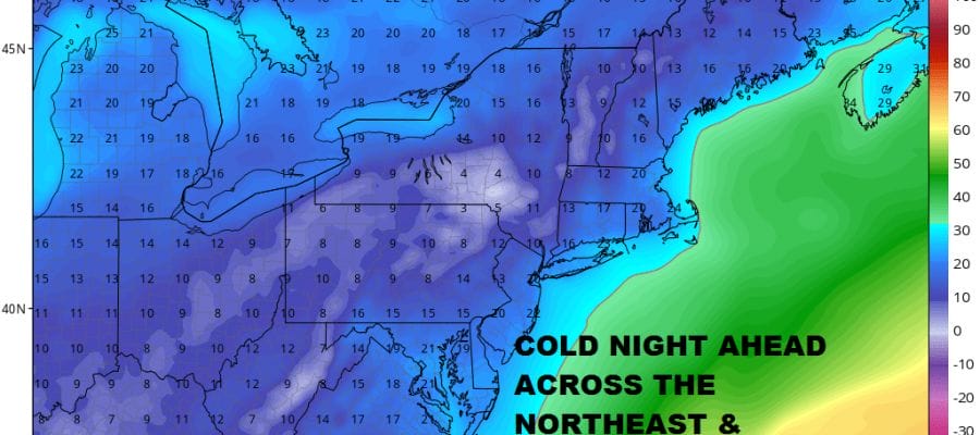
With the departing weather system offshore and a fresh snow cover for most (but not all) areas, we are setting up for a very cold night tonight. Snow cover is also now being put down in Virginia and North Carolina but that system is moving straight east and not coming here. So it will be lows in the teens to near 20 for us and some single digits not that far away. The very cold conditions extend up and down the East Coast and areas to the west as well. We do however have a nice change in pattern for the next couple of weeks it seems and that will mean temperatures after Thursday and Friday will go above normal. Skies will clear out tonight and winds will be gusty so there will be wind chills down in the single digits overnight.
US SATELLITE

The satellite picture this evening show our departing weather system off the New England coast and a second low off the North Carolina coast. That low is going to be moving to the east and not lifting northward so we have no issues to worry about with regards to it. Heavy snows in North Carolina and Virginia will pass by offshore.
REGIONAL RADAR

You can see the snow on the regional radar to the south and also to the northeast of us. We are drying out in between with a few leftover scattered snow showers.
LOCAL RADAR NEW YORK CITY

LOCAL RADAR PHILADELPHIA


Thursday will be a cold sunny day for the most part with highs just into the low and mid 30s. Some cold spots north and west of the coast may not get out of the 20s. Another cold night Thursday night into Friday morning. Friday we will see temperatures begin to moderate somewhat with sunshine and some patchy clouds. Highs should reach 35 to near 40.
This cold air mass pulls out and over the weekend we are looking ahead to some sunshine both Saturday and Sunday with highs in the upper 40s and lower 50s forecast. No weather issues are on the horizon until some rain showers come in late Monday or Monday night into Tuesday. The next storm system heads for the Great Lakes. In fact it appears that our cold pattern for the last 4 weeks will take a two week or so break. It won’t be a straight line up nor but temperatures in general will average above normal overall. There may be occasional intrusions of cold air but they should be quick in and out. A pattern shift like this is quite normal especially after the long stretch of very cold weather we have just seen.
 GET JOE A CIGAR IF YOU LIKE

FiOS1 News Weather Forecast For Long Island
FiOS1 News Weather Forecast For New Jersey
FiOS1 News Weather Forecast For Hudson Valley


