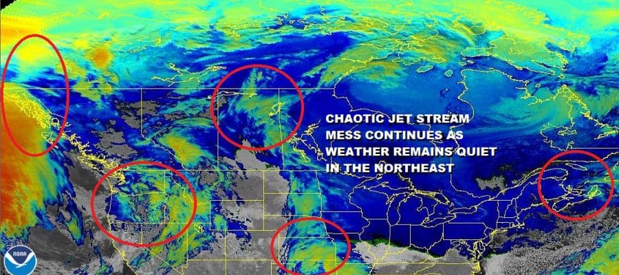
Chaotic Jet Stream Mess Continues As Does Quiet Weather Pattern
Nothing much has changed this today regarding the current state of weather across the US and Canada. Weak weather systems populate the satellite picture of Canada and the Northern half of the US. Lots of weather systems running around and most of them are weak.

The system that is on the far right hasn’t moved much since yesterday and neither have the clouds that have been overhead today. I was hoping that the sun might break through the those clouds today but there was only limited temporary success in a few places. This evening we still have clouds overhead and over much of the Northeast and Northern Middle Atlantic states. I’m hoping that we get into a little bit of partial clearing tonight. If we do that should send temperatures down to the 20s inland and the lower 30s in coastal areas.
SATELLITE

REGIONAL RADAR

Nothing much is happening on the regional and local radars and they should remain inactive through Friday so our quiet weather continues to roll along. Low pressure in the Southern Plains moves east and weakens so there is no threat from that. I’m hoping that Wednesday brings us some partial sunshine. Highs will be in the upper 30s to lower 40s. High pressure to our north will hold on into Friday. The air with this high is cold only by seasonal standards so we will just hover close to normal through Friday. That will give us highs in the 30s to near 40 Thursday and Friday and nighttime lows in the 20s to near 30. Clouds should start to increase later Friday into Friday night as we watch low pressure come out of the Gulf of Mexico.
The chaotic mess in the upper air mentioned earlier continues to create issues surrounding low pressure which is in the Gulf of Mexico Friday and then tries to come up the East Coast on Saturday. Today’s series of model runs continues to jump around with most of the them taking a low off the North Carolina coast east northeastward bringing some rain only as far north as Southern New Jersey and off the south shore of Long Island on Saturday. This leaves the vast majority of the area without any precipitation. The air aloft might be cold enough for snow however we would have to get a well developed storm nearby in order to pull that off and right now that doesn’t appear likely. We will leave the door partially open for a chance of rain or perhaps wet snow in some areas but it is conceivable that we wind up with little or nothing That would leave Saturday as a raw cloudy gloomy day with highs just in the upper 30s and lower 40s. Then perhaps we can get some sunshine back in here on Sunday. There is no real cold air behind this system so Sunday’s highs will be in the 40s.
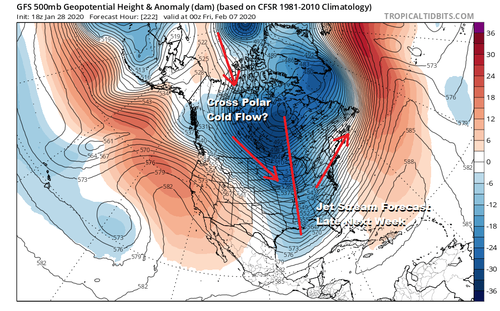
The always winter never gets here jet stream pattern in the long range is trying once again to turn things colder in the longer term. At least this time we are inside the day 10 time frame which gives it a little more support and we do have multiple models pointing to this. I remain dubious for now until we start to see this inside the 5 day time frame. This could leave the weather relatively uneventful and on the mild side early next week until another cold front passes later next week. We shall see.
BE SURE TO DOWNLOAD THE FREE METEOROLOGIST JOE CIOFFI WEATHER APP &
ANGRY BEN’S FREE WEATHER APP “THE ANGRY WEATHERMAN!
MANY THANKS TO TROPICAL TIDBITS FOR THE USE OF MAPS
Please note that with regards to any severe weather, tropical storms, or hurricanes, should a storm be threatening, please consult your local National Weather Service office or your local government officials about what action you should be taking to protect life and property.


