Beautiful Night Ahead Dry Air Remains Into Wednesday

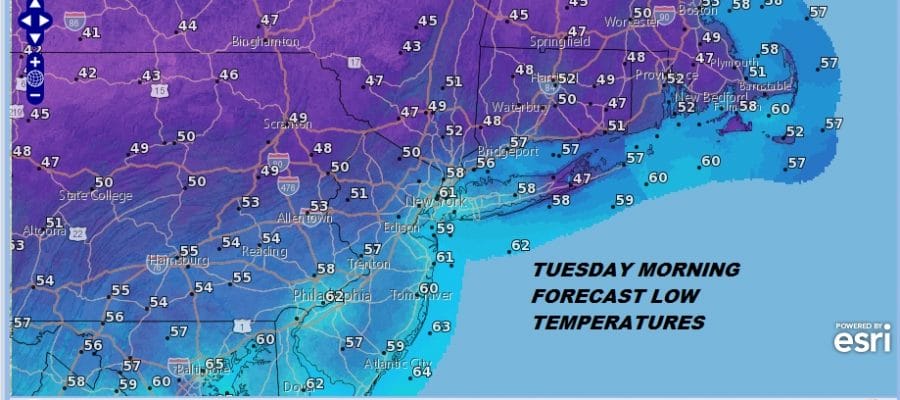
If you are inland north and west of the coast or across inland Southern New England and Long Island, don’t be shocked if the heat kicks on on tonight. Dry cool Canadian air has set the stage for a beautiful cool night of clear skies. Warmer urban centers and coastal areas will be in the upper 50s to around or just over 60. However inland 50s and even 40s show up in many of usual cold spots. This leads to another great day on Tuesday with lots of sunshine and highs in the 70s to near 80. High pressure and dry Canadian air are going to be overhead. The satellite loop shows some high clouds around but nothing more. Enjoy this while it lasts because the heat and humidity are coming at the end of the week.
EASTERN SATELLITE

REGIONAL RADAR

Wednesday we should still be dry and comfortable with sunshine giving way to arriving clouds with highs in the 70s. A warm front comes through here on Thursday with showers and thunderstorms ahead of it. Humidity goes up Thursday but clouds and showers will hold temperatures back a bit. Then Friday we start with the heat and humidity. Highs Friday could be near 90 except along the coast. The heat really gets turned on over the weekend and into next week. A strong upper high in the East will likely mean a prolonged periods of heat and humidity possibly into the middle of next week.
FOR MORE ON THE UPCOMING HEATWAVE SEE THE LATEST LONG RANGE POST FROM JOESTRADAMUS
 GET JOE A CIGAR IF YOU LIKE

LATEST JOESTRADAMUS ON THE LONG RANGE


