
Low Humidity Sunshine Tuesday Heatwave Remains On Course
Low Humidity Sunshine Tuesday
Heatwave Remains On Course
We begin this Tuesday with lots of sunshine across most of the region though there are some high clouds streaming southeastward from the Great Lakes into some areas to the south like Southern New Jersey and Southeastern Pennsylvania. Overall it should be a very nice day with low humidity and temperatures topping out in the 70s to near 80. This is about as nice as it gets this time of year when you have these Canadian highs coming in. This will be the last of those air masses as we continue to see the transition to hot humid weather for this weekend and into next week.
EASTERN SATELLITE

REGIONAL RADAR

There is nothing to worry about on the radars both today and Wednesday. Look for clear skies tonight with lows in the 50s to lower 60s. Wednesday we should start with some sunshine and then some clouds will come into the mix as the day wears on especially across Western & Southern New Jersey & Eastern Pennsylvania. Some showers could get into Eastern Pennsylvania Wednesday afternoon but they should be held back from reaching coastal areas until Wednesday night at some point. Temperatures will be in the 70s to near 80 again. Thursday we will see some showers and thunderstorms especially during the morning hours.
NAM RAINFALL FORECAST THROUGH THURSDAY
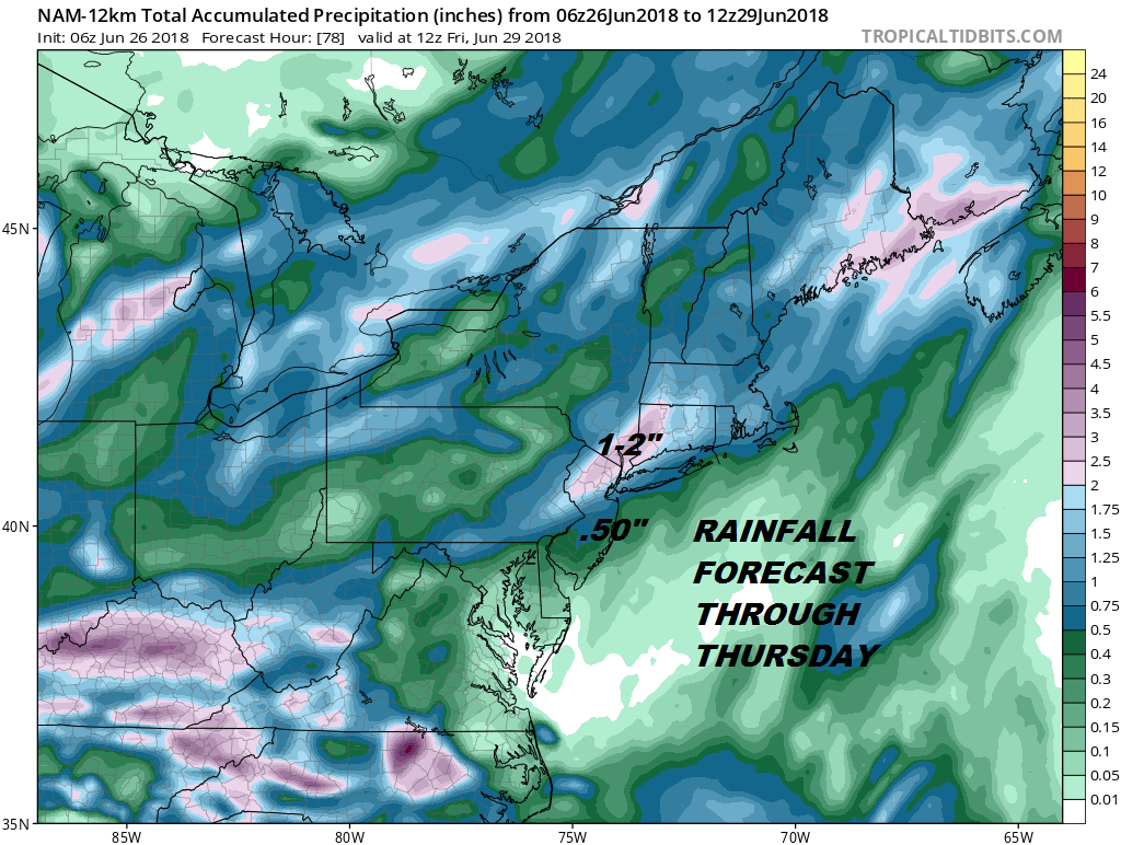
Rainfall amounts will depend on how the thunderstorms and heavy downpours set up on radar. Some areas will see an inch or 2..others much less. Also look for this forecast map to change a bit over the next 48 hours as models attempt to figure out who gets into some of the heavier downpours. All of this is part of the process of transitioning over to hot and humid weather that begins on Friday.
MODELS BACK OFF FROM RIDICULOUS FORECAST HIGHS
We discussed last night on the Joe & Joe Weather Show that the GFS high temperature forecasts for this hot weather were beyond ridiculous. Prints of 105 degrees showing up just didn’t make any sense. When we had our hot weather a week or so ago we noticed models showing some extreme numbers only to back off as we got closer. A forecast of near 100 initially became highs in the low 90s in reality. We tend to think the same thing is going on this time around. Highs on Friday will be well into the 80s. 90 might be confined to a few hot spots with clouds and some sunshine. Saturday Sunday and probably Monday look like we could see highs in the low to mid 90s in most (but not all) places with sunshine and high humidity. A pop up thunderstorm or two is possible on any given day.

The other issue for early next week is that winds may start to turn more southerly rather than westerly and this could also bring temperatures down into the 80s to near 90 away from the ocean. Most of the weather models seem to be going in this direction as well. We will discuss this further later today in our long range outlook.
 GET JOE A CIGAR IF YOU LIKE

LATEST JOESTRADAMUS ON THE LONG RANGE


