LAST DAY OF SUMMER FRIDAY AUTUMN ARRIVES SATURDAY
MOST HUMID SUMMER IN 50 YEAR ENDS
CLOUD ISSUES GOING FORWARD INTO NEXT WEEK
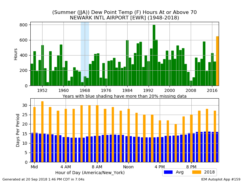
The most humid summer in 50s comes to an end Friday as the last day of summer. When measured by the number of hours of dew points over 70 this summer was the most humid for some areas in over 50 years. Areas along the immediate coast seem to experience the bulk of the suffering. Not all points hit 50 year highs but where they missed they were not that far off. This doesn’t include the last 20 days but the weather lately would have added to the numbers.
HOURS ABOVE 70 DEW POINT JFK NY

HOURS ABOVE 70 DEW POINT ISLIP NY
The hours for Islip NY above 70 dew points spiked to well over 800 hours or about 33 days if viewed consecutively.

HOURS ABOVE 70 DEW POINT ANDOVER NJ
This was surprising to see Northwest New Jersey in a spike of nearly 800 hours or 32 days of dew points above 70 if it occurred consecutively.

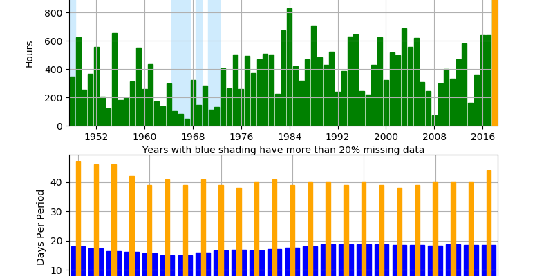
HOURS ABOVE 70 DEW POINT NEWARK NJ
While Newark spiked to over 600 hours it did not take out the spike nearly 800 hours which occurred back into the mid 1990s. It is a bit of a surprise since Newark is one of the hot spots but it is inland and cut off slightly from the ocean flow for coastal cities.
As the average temperatures drop going forward so will the time we spend with dew points above 70 so at least that is a start. At least going forward we don’t see anything overly humid though we will also not see anything overly dry either. Clouds are stubborn today with temperatures in the 70s. No rain is on the radar. We keep getting these weather fronts that push through but don’t make it that far south. There is enough of an upper high in the east to keep the very cool dry air from Canada from making a big sweep southward.
EASTERN SATELLITE

Radars remain quiet locally should remain so all night and during the day Friday.
REGIONAL RADAR

We aren’t expecting much of consequence rain wise over the next several days even though another front arrive Saturday morning with the arrival of Autumn. Friday’s highs will be in the 70s with clouds around and some breaks of sun. The front passes through Saturday morning with nothing more than a wind shift. Saturday looks like the better of the two weekend days with some sunshine and highs in the 70s to near 80 mainly due to more sun around. Sunday will be cooler due to clouds and an ocean wind with highs just in the upper 60s and lower 70s.
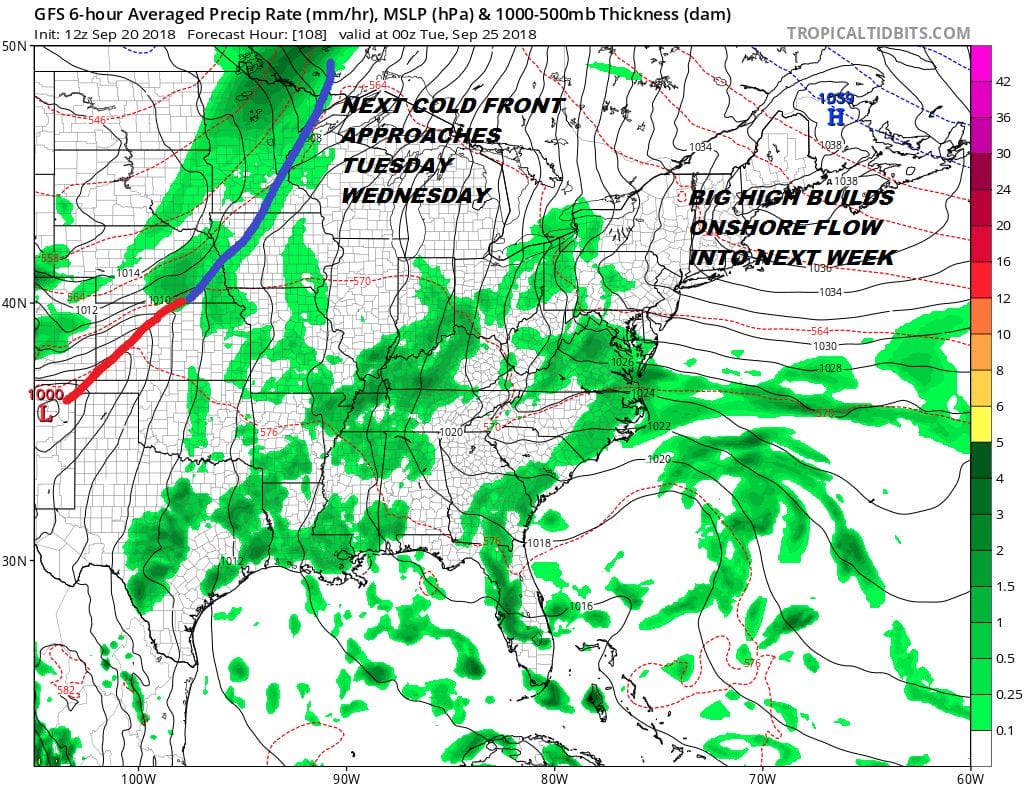
The front to the south is going to stall and a little wave develops on it. Some showers look to be close by Saturday night into Sunday over parts of Southern New Jersey & Southeastern Pennsylvania while dry air is just to our north so perhaps some of the dry air will eventually work southward Sunday. The onshore flow that sets up with strengthen a bit next week so cloud issues will continue on Monday along with higher humidity. Highs will be into the 70s. Then the chance for showers will increase Tuesday and Wednesday as a slow moving weather front moves eastward. It seems we could get a genuine shot of cool air next weekend after a stronger front passes through next Friday night with some showers.
MANY THANKS TO TROPICAL TIDBITS FOR THE USE OF MAPS
Please note that with regards to any tropical storms or hurricanes, should a storm be threatening, please consult your local National Weather Service office or your local government officials about what action you should be taking to protect life and property.
JOIN US FOR A WEATHER EXPERIENCE ON PATREON

LATEST JOESTRADAMUS ON THE LONG RANGE

