
SUMMER ENDS WITH CLOUDS ONSHORE WINDS
NEXT FRONT ARRIVES SATURDAY MORNING
WEEKEND CLOUDS COOLER ONSHORE WINDS
For many areas it was the most humid summer on record and it is finally ending technically speaking and perhaps this year the weather and the season may actually match up. We have seen the last couple of years where summery patterns tend to extend well into October as was the case last year. The longer term pattern right now suggests otherwise as we will be seeing the ridge in the Eastern US transition over to a trough and a strong flow from Canada developing over the next couple of weeks. In the meantime we have the first in a series of high pressure cells that will be moving through Eastern Canada. Onshore flow and a front to the south are putting us in some clouds today but there should be some sunshine breaking through. Temperatures today will be in the low to mid 70s for highs with no rain expected to pop up on the radar.
EASTERN SATELLITE

REGIONAL RADAR

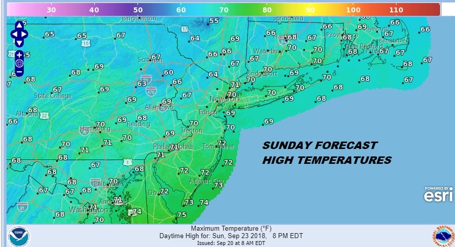
As the weather pattern evolves over the next week or two we will see cold front coming through every three days or so. The next one approaches Friday so we will see some sun and clouds with highs in the upper 70s and lower 80s. The front comes through with very liitte in the way of shower activity and then stalls to our south this weekend. This will be another situation where dry air from New England will be pushing against the stalled front across the Middle Atlantic States with the risk for rain along the boundary. The boundary zone will be close by so we will see clouds with the chance for showers the further south you go (Southern New Jersey Southeastern Pennsylvania) while there is the chance for some breaks of sun as you go further north of NYC. Temperatures will be in the 70s Saturday but highs will only be in the 60s to near 70.
No big storms are on the horizon and we will start next week with clouds on Monday. The old stalled weekend front begins to move back northward on Tuesday with the chance for showers developing and that continues next Wednesday as the next cold front arrives.
MANY THANKS TO TROPICAL TIDBITS FOR THE USE OF MAPS
Please note that with regards to any tropical storms or hurricanes, should a storm be threatening, please consult your local National Weather Service office or your local government officials about what action you should be taking to protect life and property.
LATEST JOESTRADAMUS ON THE LONG RANGE


