
Another Summer Day Late Storms Wednesday Thursday
Friday Through the Weekend Looks Beautiful
Think back to a few weekends ago when we had what I then this described as the best weekend of the summer so far. Well my thinking is that this stretch beginning Friday and lasting into Monday of next week will wind up being the best weather stretch of the summer. However we do have to get there first and in the meantime our summer round of humidity with some heat thrown in continues today. The satellite picture shows that a little but of dry air is bleeding southward to about the latitude of NYC. To the north of that line today it slightly less humid. To the south of that line it remains very humid with dew points above 70. We can actually see it pretty well by what looks like a hazy-ness on the satellite shot below. Where it looks hazy is where your humidity is running high and in this area we could see a pop up shower or thunderstorm later today with lower chances as you go north.
SATELLITE

REGIONAL RADAR

We don’t see much of anything going so far on the regional and local radars though I would look for scattered pop up downpours and thunderstorms later today and the best chance of that will be from Central and Southern New Jersey south and west.
LOCAL RADAR NEW YORK CITY

LOCAL RADAR PHILADELPHIA 

When we look at temperatures today we will see the areas with the high humidity reach the lower 90s while to the north middle 80s will do it as far as high temperatures go. So for some today it is a bit of break..for others no break at all in the steamy conditions.

Tonight we will see the steamy humidity move back northward and that could trigger off a few downpours or a thunderstorm overnight into daybreak as the very warm humid air advances northward. Overnight temperatures will be in the mid 60s to lower 70s. Then we are on our way to the first of two cold fronts with Wednesday being hot and humid with sunshine and clouds and the likelihood of thunderstorms late in the day.

The Storm Prediction Center has a risk area up for Wednesday from Southeast Pennsylvania northeastward into New England with the higher risks as you head north into the Hudson Valley and the Catskills. This is the first of two cold fronts with the second and more important one arriving for later Thursday which will be the last day of heat and humidity with highs in the upper 80s and lower 90s. There could be another round of showers and thunderstorms late in the afternoon on Thursday.
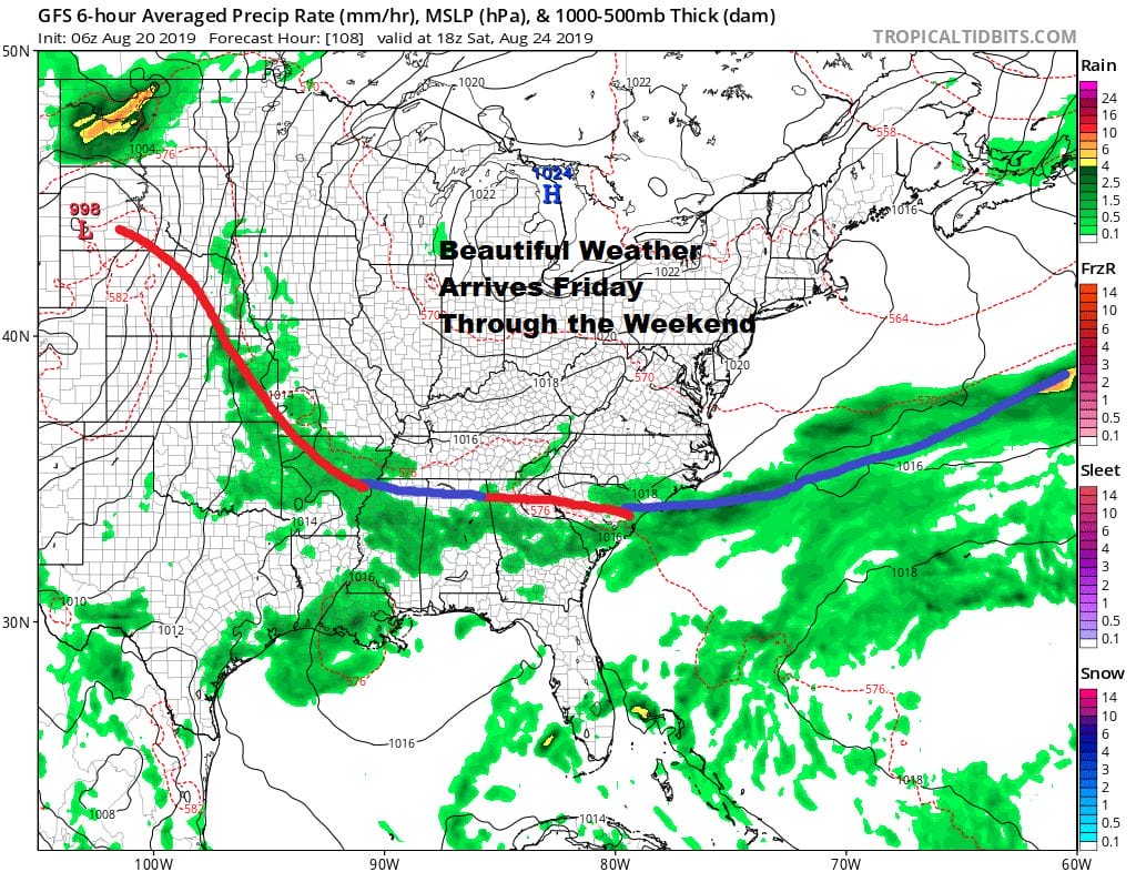
Once this next front moves through it keeps on going and drops well south into the Carolinas back to the Gulf States. The next high is a large one and we have the northern part of the stream coming down into the Middle Atlantic states. This sets us up for gorgeous weather starting Friday and lasting perhaps into Monday of next week. Friday sunshine and low humidity and pleasant temperatures take over with highs just in the upper 70s to lower 80s and Saturday we will see lots of sunshine with highs in the 70s. Sunday it continues with highs in the 70s to near 80s. This is the second to last weekend of the summer vacation season with next weekend being the Labor Day holiday weekend. We have been doing well with good weather on the weekends and this one could very well be even better than the one 2 weekends ago.
MANY THANKS TO TROPICAL TIDBITS FOR THE USE OF MAPS
Please note that with regards to any tropical storms or hurricanes, should a storm be threatening, please consult your local National Weather Service office or your local government officials about what action you should be taking to protect life and property.


