Severe Weather Risk Elevated Wednesday Weekend Humidity Relief On Course
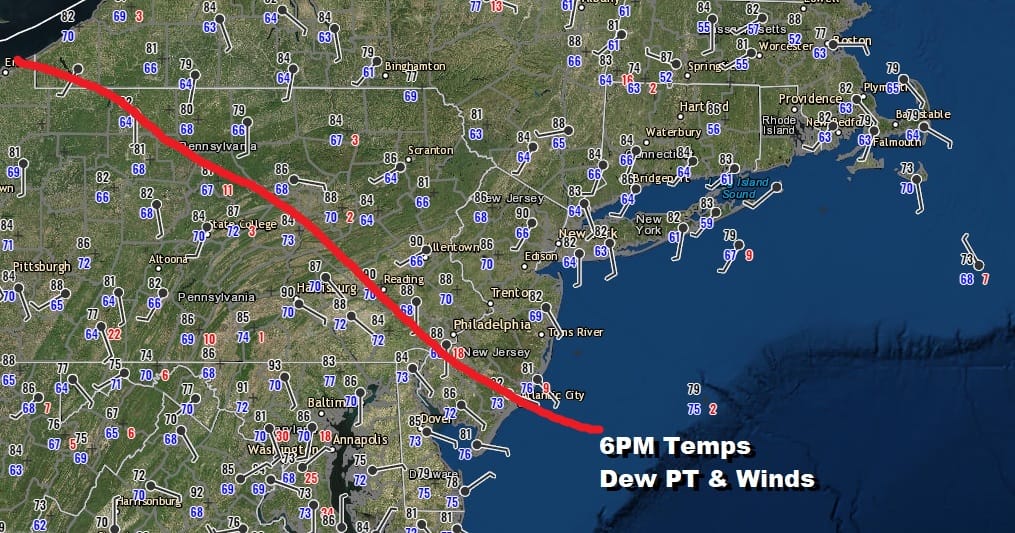
We did see some brief humidity relief as little as it was for areas from NYC north and east today while areas to the south and west stayed inside a very moist tropical air mass. There is a weak warm front developing as the map above illustrates and we can also see it on the satellite loop. Clouds to the south along with some pop up thunderstorms that are well inland into Southern Pennsylvania are extending south into Virginia where the storms are a bit more numerous. This warm front will be heading back northward tonight and an overnight downpour or a thunderstorm is possible as the front goes by so if something wakes up up in the dead of night, you will know that the warm front is in the process of going by. Let your mate know this as he or she will be impressed.
SATELLITE

REGIONAL RADAR

The regional radar shows no activity across Northeast Pennsylvania to Southern New England but we do see some heavier thunderstorms in parts of Maryland and Virginia. This is inside the warm sector. Most of these storms will die out this evening. The warm front moves northward into New England Wednesday morning. Lows tonight will be in the mid 60s to lower 70s in most places.
LOCAL RADAR NEW YORK CITY

LOCAL RADAR PHILADELPHIA 

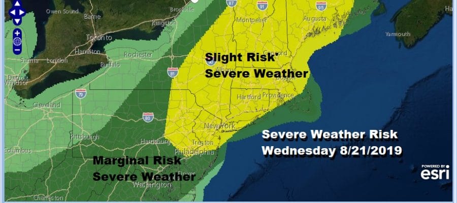
Wednesday morning we will be quickly transitioning into the steamy tropical air mass that was here in Monday. Humidity levels will be very high again and we will have some sunshine breaking through the clouds. Temperatures are destined to reach the upper 80s to lower 90s. This is going to be sufficient daytime heating and we have the first of two cold fronts moving through Thunderstorms are likely later Wednesday afternoon and evening. This could be another round of severe weather. The Storm Prediction Center is getting ahead of the game here and has upgraded the risk areas in the Northeast and Middle Atlantic States.
It will be all about the warm sector again on Wednesday and how much daytime heating we get. If we get downpours going by tomorrow morning and break out quickly into sunshine afterwards then get set for a rough evening of weather. If it takes longer for sunshine to break out on Wednesday that will cut down on the heating and should cut down on the severity of the storms. We will be watching for clues in the morning.
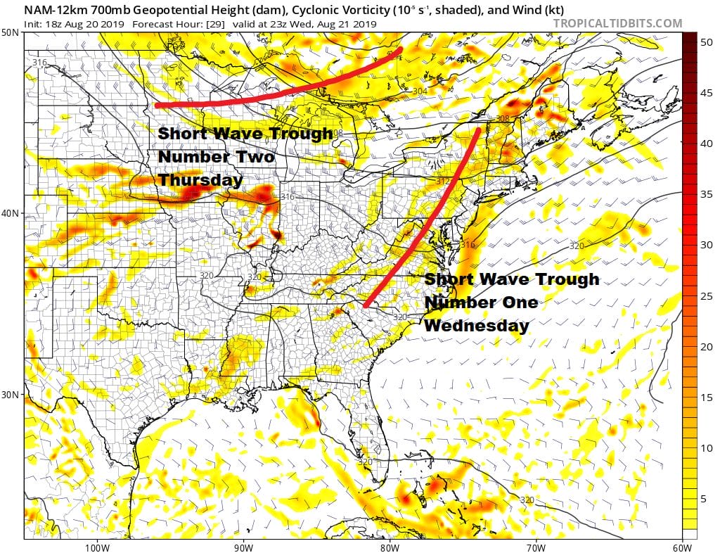
The upper air is lending some support to strong thunderstorms with this first short wave trough in the upper atmosphere swinging through Wednesday evening producing some jet streaks of gusty winds at the 10,000 foot level. This is usually a good indicator of severe weather though we have seen some stronger short waves move through in the last few weeks. Then there is a second shortwave trough behind it that will arrive late Thursday pushing a second cold front through. This seems to be moving through a bit slower this afternoon on weather models It does produce another round of showers and thunderstorms Thursday evening. Thursday will still be rather humid until this front passes with highs in the 80s to near 90.
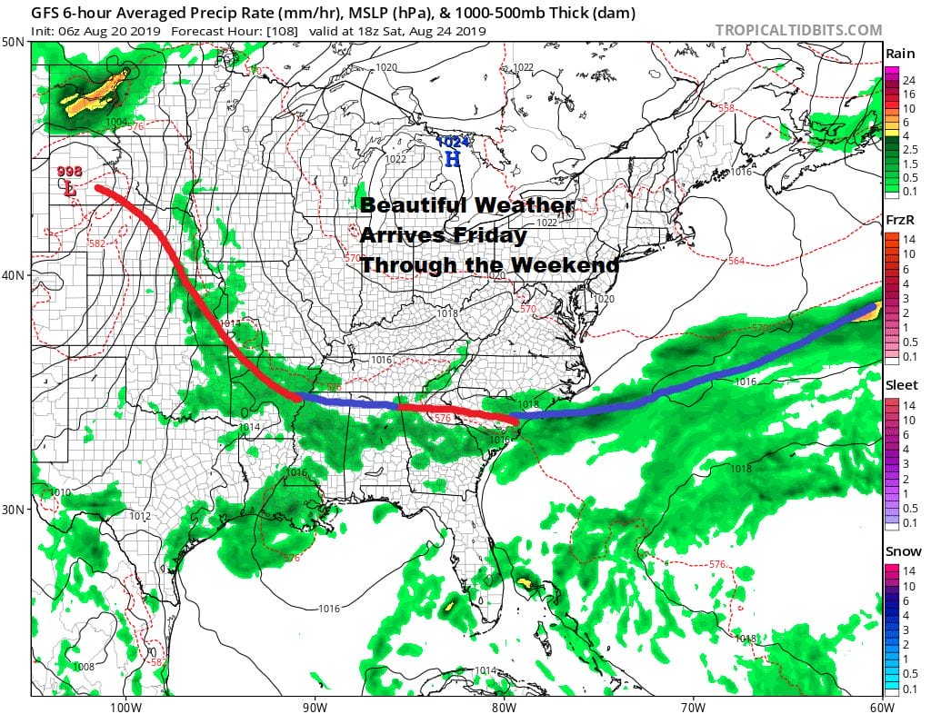
Finally we will start to see dry air arrive on Friday with leftover clouds early giving way to some sunshine with highs in the upper 70s to lower 80s. Saturday and Sunday look to be delightfully dry with sunshine and a northeast breeze. Most highs will be in the 70s to near 80 with low humidity. Nighttime lows will be in the pleasant 50s in most places with lower 60s in the warmer urban areas. It is really looking like a lovely weekend and every bit as nice as the weekend we enjoyed at the beginning of this month.
MANY THANKS TO TROPICAL TIDBITS FOR THE USE OF MAPS
Please note that with regards to any tropical storms or hurricanes, should a storm be threatening, please consult your local National Weather Service office or your local government officials about what action you should be taking to protect life and property.


