
Afternoon Model Runs No Important Changes Sleet Snow Rain South
Afternoon Model Runs No Important Changes
Sleet Snow Rain South
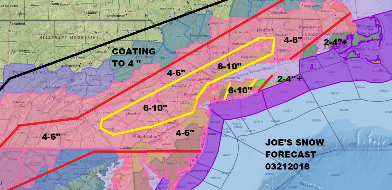
There are no changes in my snow forecast after looking at all the models this afternoon. The NAM model remains the most aggressive with the Canadian and GFS model not that far off. At this stage of the game we are at the point where we should just let it roll in and do what it is going to do. Could my numbers be low? Sure they could. In some places on the northwestern fringe of this they could be too high. If this were early March I would be less hesitant to go higher. There are just too many intangible variables like the surface temperatures for example. Will it be 33/34 like in the last storm or more like 31/30? It is certainly obvious that it is cold outside this time around before the storm unlike the last two storms. Sun angle is going to play a part for a time tomorrow but after 3pm or so that factor diminishes. Since we will be snowing well into tomorrow evening and in some areas east well into tomorrow night, what you don’t get early in the day you will probably get later on. Im remaining conservative.
US SATELLITE

The moisture field on the latest satellite and radar with the first wave is rather impressive. Radars just south of NYC are loaded however there is so much dry air around at the low levels that the precipitation is having a tough time reach the ground at the moment. It is aloft over New York City & Long Island but you have to go south of Route 195 to find where it is reaching the ground. We should see this progress a little further north into this evening before this first batch retreats a bit for the first part of tonight; at least that is the plan at the moment.
REGIONAL RADAR

LOCAL RADAR NEW YORK CITY

LOCAL RADAR PHILADELPHIA


Wednesday morning the second low revs up and snow pushes northward and moves north of NYC before daybreak. The heaviest snow across much of the area will fall from mid morning through mid evening at least. Winds along the coast will gust to 40 mph or higher. Coastal flooding will be a problem into Wednesday evening as this long easterly fetch develops and strengthens. Coastal Flood Warnings have already been issued for Long Island and most of the New Jersey shore from Ocean County southward.
NAM MODEL LIQUID PRECIPITATION FORECAST
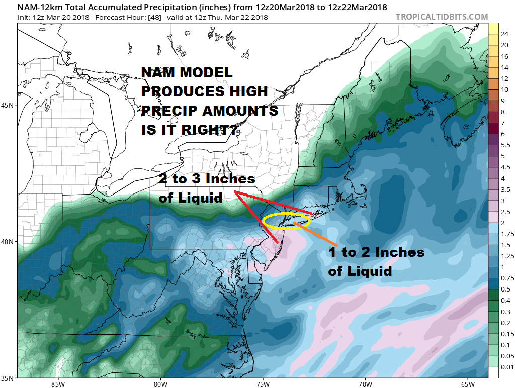
Above is the NAM model forecast of total liquid precipitation for this storm and it is substantial. The question is will it verify. Another question is how much falls as snow and what will the snow ratio’s be? One of the things we will be doing this evening is to see how well the nam is doing with the lead low and the precipitation it produces. If it matches up well, and the radar matches up well which so far it seems to be, it would give us more confidence to lean higher.
 GET JOE A CIGAR IF YOU LIKE

FiOS1 News Weather Forecast For Long Island
FiOS1 News Weather Forecast For New Jersey
FiOS1 News Weather Forecast For Hudson Valley


