3rd Noreaster In 10 Days First Call Snow Forecast
3rd Noreaster In 10 Days First Call Snow Forecast

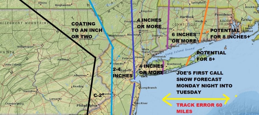
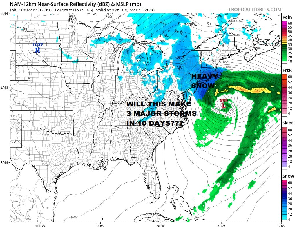
The map above is my first call snow forecast map for what now looks to be the third noreaster/coastal storm in 10 days. Weather models have been doing what they have done all winter which is to put the puzzle pieces out there and them bring them together in the short range. Afternoon model trends continue closer to the coast and more intense with a coastal low that will develop along the Carolina coast and move northeastward from there.
This time around it appears that the coast is in position for a heavy snowfall with less amounts inland. What i have indicated on the map is roughly a 60 mile margin of error. Further left and we will pushing the snow boundaries further inland. If we suddenly go to the east then we shift in the other direction. Given that the NAM model continues to hold a very hot hand i have taken its liquid precipitation forecast of 1/2 the 3/4 inch of liquid back to NYC and basically made that the back edge of 4 inches. I think these are fair numbers for the time being.
US SATELLITE

REGIONAL RADAR

Meanwhile we continue to be under the influence of the old storm that is sitting between Nova Scotia and New Foundland with cold unstable air overhead producing clouds and occasional snow showers which are evident on the local radars. Look for that activity to decrease this evening and we should see skies partially clear. Lows will be in the 20s to lower 30s. Sunday looks good with mainly sunny skies and highs into the 40s.
LOCAL RADAR NEW YORK CITY

LOCAL RADAR PHILADELPHIA


Monday look for increasing clouds from the south. Snow will likely develop in the evening sometime and last into early Tuesday afternoon. Since we will see snow during the overnight hours it will stick and it could also stick in the warmer urban areas which basically avoided any large snowfall in the last event. Weather models will be monitored closely for any changes going forward. The back and forth torture begins.
NATIONAL WEATHER SERVICE SNOW FORECAST MAPS ARE POSTED WITH THEIR FIRST CALL
 GET JOE A CIGAR IF YOU LIKE

FiOS1 News Weather Forecast For Long Island
FiOS1 News Weather Forecast For New Jersey
FiOS1 News Weather Forecast For Hudson Valley


