Hurricane Gert Tropical Waves Active Atlantic
Hurricane Gert Tropical Waves Active Atlantic

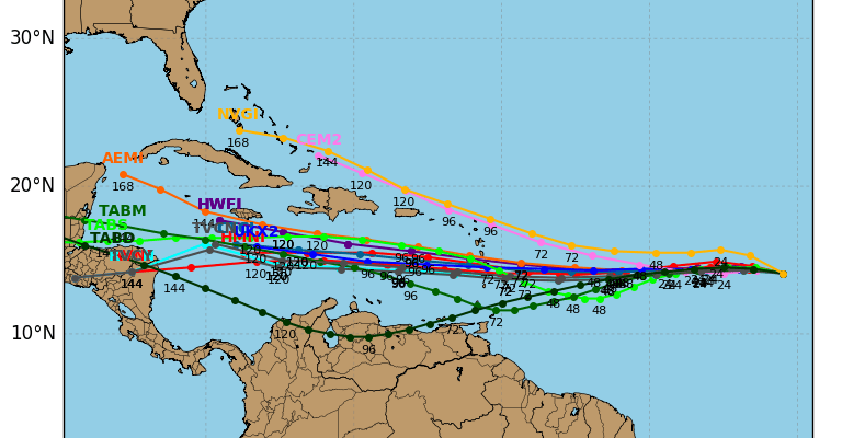
Hurricane Gert continues to organize and strengthen this morning. The outflow pattern remains impressive, water temperatures are very warm, and the wind shear environment is light. Overnight the eye disappeared but I suspect we will see that show up again later today. Hurricane Gert is no threat to land though we will see it kick up the surf along our coast line over the next couple of days.
…GERT EXPECTED TO TURN TOWARD THE NORTHEAST LATER TODAY…
SUMMARY OF 500 AM EDT…0900 UTC…INFORMATION
———————————————-
LOCATION…31.8N 72.5W
ABOUT 450 MI…725 KM W OF BERMUDA
MAXIMUM SUSTAINED WINDS…75 MPH…120 KM/H
PRESENT MOVEMENT…N OR 360 DEGREES AT 12 MPH…19 KM/H
MINIMUM CENTRAL PRESSURE…986 MB…29.12 INCHES
WATCHES AND WARNINGS
——————–
There are no coastal watches or warnings in effect.
DISCUSSION AND 48-HOUR OUTLOOK
——————————
At 500 AM EDT (0900 UTC), the center of Hurricane Gert was located
near latitude 31.8 North, longitude 72.5 West. Gert is moving toward
the north near 12 mph (19 km/h). A turn toward the northeast with
an increase in forward speed is expected later today.
Maximum sustained winds remain near 75 mph (120 km/h) with higher
gusts. Gert has the opportunity to gather some strength later
today or Wednesday.
Hurricane-force winds extend outward up to 25 miles (35 km) from the
center and tropical-storm-force winds extend outward up to 105 miles
(165 km).
The estimated minimum central pressure is 986 mb (29.12 inches).

Elsewhere in the tropics there are two active tropical waves in the Eastern Atlantic and both actually look better defined this morning especially the one that is furthest east. Both are tracking westward. Upper air conditions remain conducive for development over the next several days.


MANY THANKS TO TROPICAL TIDBITS FOR THE WONDERFUL USE OF THE MAPS
Weather App

Don’t be without Meteorologist Joe Cioffi’s weather app. It is really a meteorologist app because you get my forecasts and my analysis and not some automated computer generated forecast based on the GFS model. This is why your app forecast changes every 6 hours. It is model driven with no human input at all. It gives you an icon, a temperature and no insight whatsoever.
It is a complete weather app to suit your forecast needs. All the weather information you need is right on your phone. Android or I-phone, use it to keep track of all the latest weather information and forecasts. This weather app is also free of advertising so you don’t have to worry about security issues with your device. An accurate forecast and no worries that your device is being compromised.
Use it in conjunction with my website and my facebook and twitter and you have complete weather coverage of all the latest weather and the long range outlook. The website has been redone and upgraded. Its easy to use and everything is archived so you can see how well Joe does or doesn’t do when it comes to forecasts and outlooks.
Just click on the google play button or the apple store button on the sidebar for my app which is on My Weather Concierge. Download the app for free. Subscribe to my forecasts on an ad free environment for just 99 cents a month.
Get my forecasts in the palm of your hand for less than the cost of a cup of Joe!