Zeta Landfalls Accelerates Northeast To Mid Atlantic Thursday
Rain Wind Into Friday, Snow Well North

Weather in 5/Joe & Joe Weather Show Latest Podcast
Zeta Landfalls Accelerates Northeast To Mid Atlantic Thursday
Rain Wind Into Friday, Snow Well North
Flash Flood Watch Central Southern New Jersey southward into Delaware Maryland and Virginia has been posted ahead of the rains from Hurricane Zeta. Landfall occurred late this afternoon and there was a bit of a surprise on the final approach as Zeta strengthened. The hurricane fed off of a deep trough to the west in Texas and began moving at 20 to 25 mph. This negated the negative influence of cooler water and increasing wind shear. Tropical Storm Warnings are now posted through Alabama, North Georgia into the Western North Carolina mountains. Zeta will be transitioning to a post tropical cyclone and will likely hold on to gale force winds as it makes its way through the Central Appalachians and then off the Delaware coast late Thursday.
SATELLITE

REGIONAL RADAR

Clouds never really got out of the way today and now they continue to increase and thicken up. Rain on the regional radar is advancing from Western North Carolina and Western Virginia and it should arrive here around or before daybreak from NYC south and shortly afterwards over Southern New England and Long Island. This evening our local radars are silent but they won’t be for much longer.
LOCAL RADAR NEW YORK CITY

LOCAL RADAR PHILADELPHIA


Thursday will be all about Zeta moving rapidly northeastward. Maximum sustained winds will likely hold in the 40 to 45 mph range along the track of the storm. Then it moves offshore tomorrow evening off the Delaware coast and continues rapidly northeastward passing south of Long Island around midnight Thursday night.

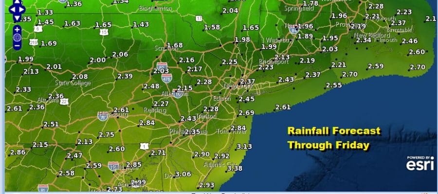
We are going to continue to stick with the idea of 2 to 3 inches of rain from NYC and Long Island southward with 1 to 2 inches if rain north of there. There could be some locally higher amounts in some places.
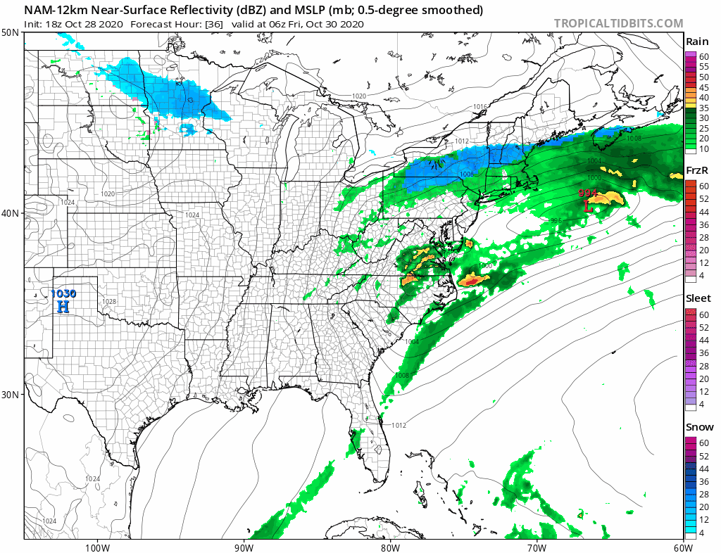
As far as the change over to snow is concerned we maintain that it will be for areas north of Route 84 and you may have to go north of Ulster and Dutchess Counties to see accumulations of a slushy few inches in some places. We didn’t see anything today that causes us to change our minds about that. The second low develops near the coast Friday and and exits quickly to the east so the window of opportunity is a short one. It is possible that some mixing could make its way to the coast.

Weather conditions improve Friday afternoon and it will be rather cold with lows in the 20s to lower 30s Saturday morning bringing first freeze conditions to much of the area from Eastern Pennsylvania to Southern New England. Sunshine is back for Saturday with highs just in the 40s. We will be back into the 50s on Sunday but an even colder shot of air arrives Sunday night lasting into Tuesday of next week.
BE SURE TO DOWNLOAD THE FREE METEOROLOGIST JOE CIOFFI WEATHER APP &
ANGRY BEN’S FREE WEATHER APP “THE ANGRY WEATHERMAN!
MANY THANKS TO TROPICAL TIDBITS FOR THE USE OF MAPS
Please note that with regards to any severe weather, tropical storms, or hurricanes, should a storm be threatening, please consult your local National Weather Service office or your local government officials about what action you should be taking to protect life and property.


