Morning Showers Exit Clouds Linger Zeta Rains Wind Thursday Colder Friday Into Weekend

Weather in 5/Joe & Joe Weather Show Latest Podcast
Morning Showers Exit Clouds Linger Zeta Rains Wind Thursday Colder Friday Into Weekend
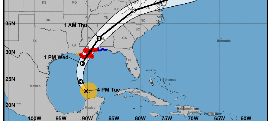
The day begins with an upper air disturbance moving through and will end with lots of clouds around. Showers are moving eastward but they should be mostly done by mid morning. Then we spend the day with one system exiting and the beginning of another arriving. Meanwhile Hurricane Zeta is moving northward for a landfall in Southeast Louisiana late this afternoon.
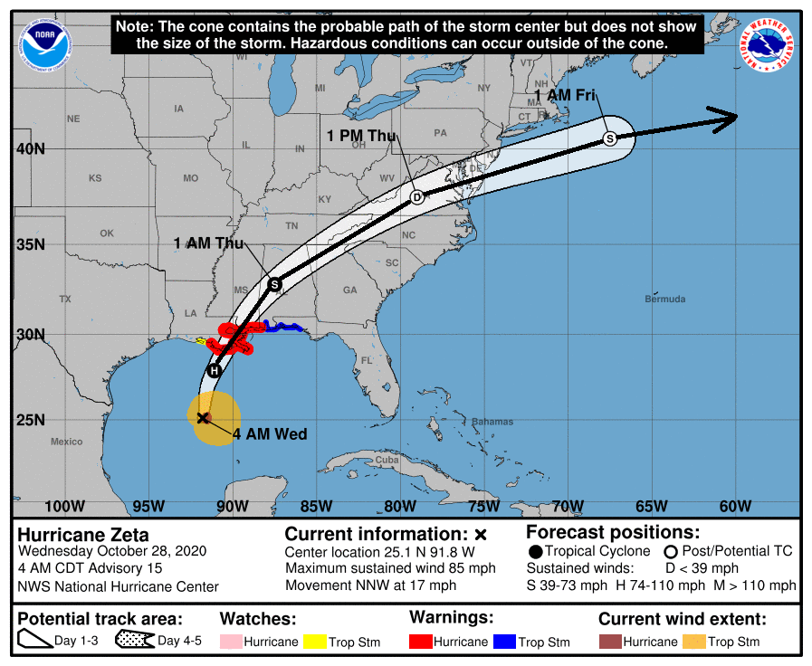
LOCATION…25.1N 91.8W
ABOUT 320 MI…520 KM SSW OF THE MOUTH OF THE MISSISSIPPI RIVER
ABOUT 355 MI…570 KM SSW OF NEW ORLEANS LOUISIANA
MAXIMUM SUSTAINED WINDS…85 MPH…140 KM/H
PRESENT MOVEMENT…NNW OR 345 DEGREES AT 17 MPH…28 KM/H
MINIMUM CENTRAL PRESSURE…982 MB…29.00 INCHES
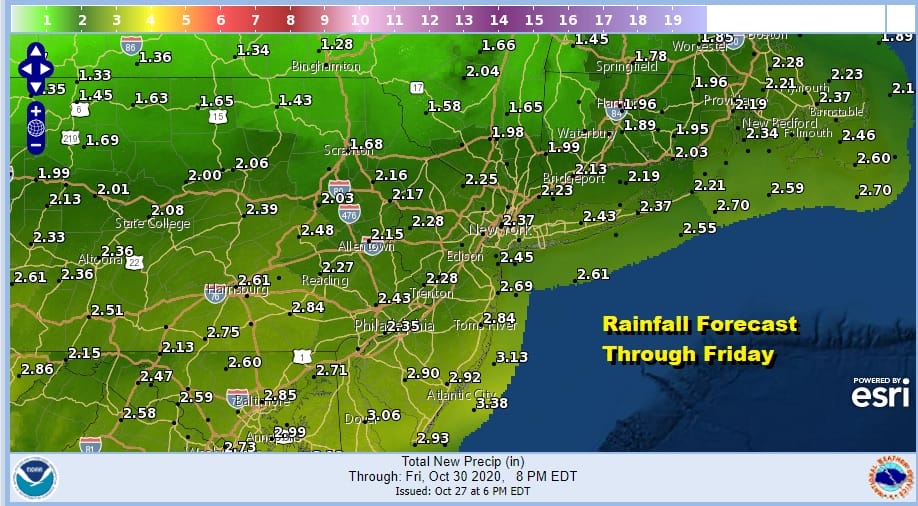
The logic behind what is going to happen Thursday and Friday remains unchanged. After landfall, Zeta accelerates northeastward passing off the Delaware coast Thursday evening and then races out to sea from there. Rain will be arriving Thursday morning and will be heavy at times into Thursday evening before moving out later in the evening. There could be a short break before a second round of rain comes later Thursday night into Friday. The NAM loop below plays it all out.

Rainfall amounts will be in the 1 to 2 inch range in the Hudson Valley and Southern New England and 2 to 4 inches everywhere else as you heads south toward Southern Pennsylvania, Maryland and Delaware.
Later Thursday night into Friday afternoon a second low develops with an upper trough approaching and the developing low pulls down cold air from the north. This will result in a mix of change to wet snow in areas mainly north of Route 84 across the Hudson Valley and Northern Connecticut.

All precipitation exits from west to east Friday afternoon and weather conditions improve. This sets us up for a mostly nice weekend though it will be cold Saturday morning with most lows in the 20s and lower 30s and highs will be just back into the 40s. We should see a good deal of sunshine however.

Sunday we will see some sun and arriving clouds as another cold front approaches. There might be a shower or two Sunday evening. Highs will be in the 50s. Then it turns windy and colder for Monday into Tuesday.
SATELLITE

REGIONAL RADAR

Meanwhile this morning we can see the showers moving through from west to east on the regional and local radars. Most of the showers are in the Northern half of Pennsylvania east to Southern New England and Long Island. Rainfall is mostly in the light side. There are a few heavier showers on the northern flank of this area.
LOCAL RADAR NEW YORK CITY

LOCAL RADAR PHILADELPHIA


Once the showers move out expect leftover clouds with some brightening or even a break or two of sun before more clouds move in late in the day. Highs will be in the upper 50s and lower 60s.
BE SURE TO DOWNLOAD THE FREE METEOROLOGIST JOE CIOFFI WEATHER APP &
ANGRY BEN’S FREE WEATHER APP “THE ANGRY WEATHERMAN!
MANY THANKS TO TROPICAL TIDBITS FOR THE USE OF MAPS
Please note that with regards to any severe weather, tropical storms, or hurricanes, should a storm be threatening, please consult your local National Weather Service office or your local government officials about what action you should be taking to protect life and property.


