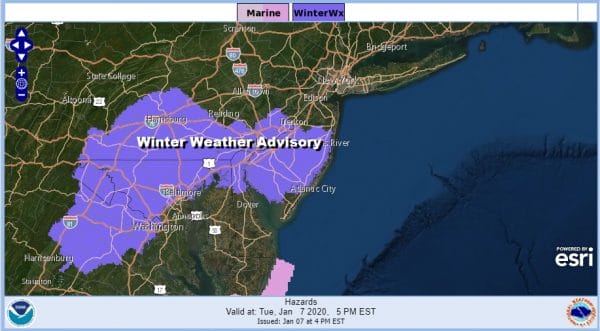
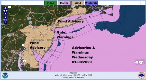
Winter Weather Advisory New Jersey RT 195 South Wind Advisory Wednesday
Winter Weather Advisory is up for New Jersey mainly from Route 195 southward as well as Southeast and South Central Pennsylvania south into Maryland and Northeast Virginia. It has been snowing heavily from Washington DC to Baltimore northwest into Pennsylvania. Parts of South Central Pennsylvania have picked up a few inches as low pressure moves northeast to off the Virginia coast this evening and then makes the pivot northeastward.
Some minor adjustments have been made on the snow forecasts from the weather service. For most it will be a coating to as much as an inch or two in some places. Others in Northwest New Jersey and the Hudson Valley just north and west of the coast will likely see very little from this system.
Wednesday winds will be kicking in from the northwest at 20 to 30 mph with gusts to over 40 mph and with an upper trough swinging through some snow showers and even a heavier snow squall is possible. Wind Advisories are posted for much of New Jersey to NYC, Long Island and Coastal Connecticut.
SATELLITE
REGIONAL RADAR
The coastal low is beginning to develop and that is causing the snow on the western part of the precipitation shield to dry up while the precipitation from the coastal low is expanding across much of the southern half of New Jersey to just south of the south shore of Long Island and it is moving north north east. Now it will be a matter of getting the intensity to create dynamic cooling and change the rain over to wet snow.
LOCAL RADAR NEW YORK CITY
LOCAL RADAR PHILADELPHIA

For the rest of this evening and into the first part of tonight while the low develops it will be a matter of watching the radar and the surface observations. Weather models have been horribly inconsistent wobbling back and forth from run to run. They really aren’t much use from here on in so we watch and track and make whatever adjustments need to made. A coating to a few inches is the general idea. If the coastal low intensifies and wobbles a bit further north it could create an upside surprise for Southernmost New England and Long Island to Coastal New Jersey so that remains on the table as a possibility.
Wednesday is cold and windy with the chance for snow squalls and temperatures just in the 30s We will wait until morning to figure out whether there might be a line of squalls like we saw a few weeks ago. Some sun and clouds will occur ahead of this. By Thursday morning we will be down in the teens to low 20s for lows. Thursday will be sunny and cold with less wind and highs in the 30s.
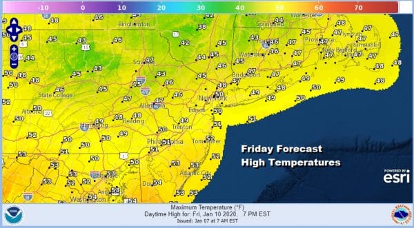
The high moves offshore to our south and the southwest flow begins with very warm air surging up the East Coast Friday. Highs Friday will reach into the upper 40s and lower 50s. We will go higher still on Saturday as highs reach into the 60s! Showers are likely late Saturday and Saturday night as a cold front passes. Temperatures will ease somewhat on Sunday.
BE SURE TO DOWNLOAD THE FREE METEOROLOGIST JOE CIOFFI WEATHER APP &
ANGRY BEN’S FREE WEATHER APP “THE ANGRY WEATHERMAN!
MANY THANKS TO TROPICAL TIDBITS FOR THE USE OF MAPS
Please note that with regards to any severe weather, tropical storms, or hurricanes, should a storm be threatening, please consult your local National Weather Service office or your local government officials about what action you should be taking to protect life and property.


