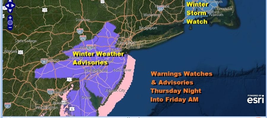
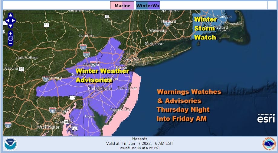
Winter Weather Advisories Most of New Jersey
Southeast & South Central Pennsylvania Thursday Night Into Friday

Weather in 5/Joe & Joe Weather Show Latest Podcast
Winter Weather Advisories Most of New Jersey
Southeast & South Central Pennsylvania Thursday Night Into Friday
We are setting up for another round of winter weather and this weather system has issues much like the last one. This is not going to be one where a sharp cut off forms thanks to very cold dry air dropping southward from New England. This is going to be a storm that develops in the Southern Appalachians and heads northeast to the Carolina coast and then offshore. The issue here is that the upper air is very lackluster to say the least and that means that this will not be a major storm like the one we saw Monday.
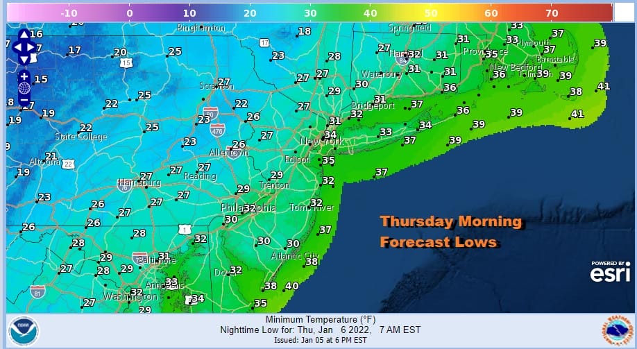
Many areas this morning around NYC saw icing that created big issues during the morning commute. That was leftover cold air from overnight and this morning that did not get dislodged as advertised. Fortunately we warmed into the 40s today and we have no such issue to deal with tonight into Thursday morning. A cold front is passing offshore and leftover clouds will give way to clearing skies overnight with lows by morning in the upper 20s and lower 30s in most places.
SATELLITE

WEATHER RADAR

Thursday should be a nice day with sunshine at least into the afternoon before we start to see some clouds increasing. Highs will be in the mid to upper 30s in most places. The warmest spots could touch 40. The attention turns to low pressure moving across the Deep South and then turning northeast to the North Carolina coast Friday morning.

As we get closer to this event we are noticing that models are growing weaker and weaker and this is due to the lackluster upper air support this system has. Winter Weather Advisories nonetheless are posted tonight for most of New Jersey, Eastern, Southeastern and South Central PA, Delaware, Maryland and Virginia. Note that this map is showing advisories that are in effect starting Friday morning.
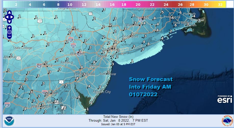
As for snow amounts, a weaker system certainly argues for lower amounts than being indicated by NWS here. We are a firm believer in not changing snow forecasts every 6 hours based on whims of guidance. There were the forecast numbers put out by NWS today. Again I think right now that they are high and probably need to come down somewhat. Snow will spread southwest to northeast late Thursday and Thursday night and for most areas the snow should be done Friday morning.
The storm pulls away Friday and weather conditions improve as it turns sunny with a gusty northwest wind. The weekend looks good for Saturday but clouds arrive Sunday along with an arctic front and some showers late in the day and at night. This will be followed by a quick shot of very cold air for later Monday and Tuesday.
BE SURE TO DOWNLOAD THE FREE METEOROLOGIST JOE CIOFFI WEATHER APP &
ANGRY BEN’S FREE WEATHER APP “THE ANGRY WEATHERMAN!

MANY THANKS TO TROPICAL TIDBITS & F5 WEATHER FOR THE USE OF MAPS
Please note that with regards to any severe weather, tropical storms, or hurricanes, should a storm be threatening, please consult your local National Weather Service office or your local government officials about what action you should be taking to protect life and property.


