
Weather in 5/Joe & Joe Weather Show Latest Podcast
Morning Winter Weather Advisories Expiring
Warmer Day Ahead Before Cold Returns Snow Chance Continues

Morning winter weather advisories from Delaware through New Jersey, the Lower Hudson Valley, Connecticut and Long Island are expiring this morning as temperatures start their climb. There will some spotty rain freezing rain and snow around, as warmer moved northward and overran the cold air. Now we will see winds shift to the west as the day wears on. High temperatures late today or this evening will reach the 40s. The cold air may take a while to dislodge and there will also be a lot of clouds and spotty rain around as well.
SATELLITE

WEATHER RADAR

A cold front will be moving offshore tonight so clouds this evening will give way to clearing skies overnight. Morning lows will be in the upper 20s to lower 30s in most places. Thursday will be a colder day with sunshine giving way to some late day arriving clouds. Highs will be in the upper 30s to around 40 degrees.

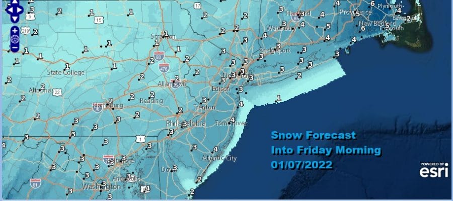
We are still on course for some snow Thursday night into Friday morning. Models have been kind of going back and forth a little here in terms of strength. It boils down to where the low is when it starts to intensify. Last night’s nam was a little more robust. We were thinking that this could be a 2 to 4 inch type snowfall and we are going to leave it that way for now.
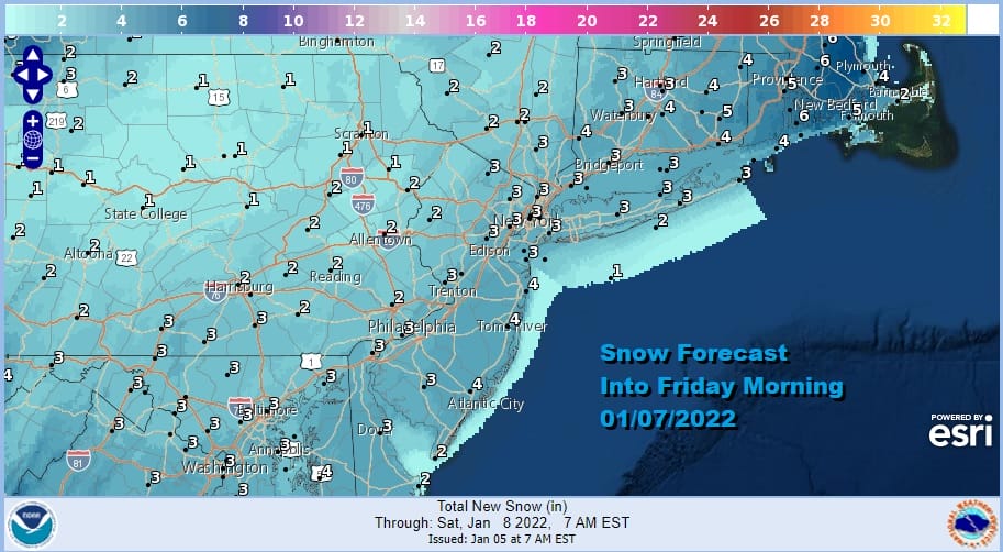
The NWS average forecast this is morning is for around 3 with higher amounts in Southeastern New England. Snow comes in Thursday night and then ends Friday morning with the storm moving away to the northeast. Weather conditions should improve from south to north from mid morning to mid afternoon. Temperatures overnight Thursday night will be in the upper 20s and lower 30s and hold there on Friday at least while it is snowing. It will also become windy at times Friday as low deepens in the Gulf of Maine and over Nova Scotia. Saturday looks sunny and cold. An arctic front approaches late Sunday with some rain showers and passes offshore Monday. Behind it we have very cold air coming in for the Tuesday and Wednesday of next week.
BE SURE TO DOWNLOAD THE FREE METEOROLOGIST JOE CIOFFI WEATHER APP &
ANGRY BEN’S FREE WEATHER APP “THE ANGRY WEATHERMAN!

MANY THANKS TO TROPICAL TIDBITS & F5 WEATHER FOR THE USE OF MAPS
Please note that with regards to any severe weather, tropical storms, or hurricanes, should a storm be threatening, please consult your local National Weather Service office or your local government officials about what action you should be taking to protect life and property.


