Winter Storm Winding Down But Still Causing Issues

Winter Storm Winding Down But Still Causing Issues
The winter storm which brought 1 foot plus snow across the Northern third of New Jersey and 1 to 2 feet across the Hudson Valley is winding down from the standpoint of accumulating snows but it continues to produce blizzard conditions with light snow/sleet/blowing snow with visibilities under 1/4 of a mile. Roads are in horrible shape across those regions and will likely remain so until road crews can continue their cleanups.
On Long Island snowfall was in the 3 to 5 inch range followed by heavy sleet and rain earlier and then just rain is also winding down. Winds have been gusting to 50 to 60 mph as the low center moved east just along the south shore of Long Island. Coastal flooding issues for both Long Island and New Jersey should diminish slowly overnight with winds from the north northwest. Very cold air however is moving in behind the storm and temperatures tonight will drop to the teens and low 20s which means anything standing water will freeze on roadways.
Over Central and South Jersey snow amounts were minimal last night into this morning…generally under 4 inches followed by rain that washed it away. But temperatures are falling now and some snow showers are possible this evening.
In Connecticut where snow totals were a foot plus in many locations, we should see the last of any snow taper off and weather conditions improving very slowly but again a very cold night is ahead with lows in the teens.
SATELLITE LOOP

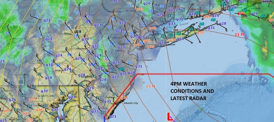
REGIONAL RADAR

LOCAL RADAR NEW YORK CITY

LOCAL RADAR PHILADELPHIA


Wednesday we will see clouds with just limited sun and a few snow showers with highs just in the 20s. Cold air remains for the rest of the week with some sunshine Thurdsay and Friday but highs just into the 30s.
HERE ARE SOME SNOW REPORTS FROM NORTHEAST NEW JERSEY TO SOUTHERN NEW ENGLAND AND LONG ISLAND
HERE ARE SOME SNOW REPORTS FROM CENTRAL SOUTHERN NEW JERSEY AND EASTERN PENNSYLVANIA
 GET JOE A CIGAR IF YOU LIKE

SNOW REMOVAL COMPANIES FOR YOUR WINTER NEEDS
LONG ISLAND ROCKLAND COUNTY Connecticut

![]()

ROCKLAND COUNTY TRI STATE SNOW REMOVAL JOHNSTOWN PA


FiOS1 News Weather Forecast For Long Island
FiOS1 News Weather Forecast For New Jersey
FiOS1 News Weather Forecast For Hudson Valley
NATIONAL WEATHER SERVICE SNOW FORECASTS
LATEST JOESTRADAMUS ON THE LONG RANGE
Weather App

Don’t be without Meteorologist Joe Cioffi’s weather app. It is really a meteorologist app because you get my forecasts and my analysis and not some automated computer generated forecast based on the GFS model. This is why your app forecast changes every 6 hours. It is model driven with no human input at all. It gives you an icon, a temperature and no insight whatsoever.
It is a complete weather app to suit your forecast needs. All the weather information you need is right on your phone. Android or I-phone, use it to keep track of all the latest weather information and forecasts. This weather app is also free of advertising so you don’t have to worry about security issues with your device. An accurate forecast and no worries that your device is being compromised.
Use it in conjunction with my website and my facebook and twitter and you have complete weather coverage of all the latest weather and the long range outlook. The website has been redone and upgraded. Its easy to use and everything is archived so you can see how well Joe does or doesn’t do when it comes to forecasts and outlooks.
Just click on the google play button or the apple store button on the sidebar for my app which is on My Weather Concierge. Download the app for free. Subscribe to my forecasts on an ad free environment for just 99 cents a month.
Get my forecasts in the palm of your hand for less than the cost of a cup of Joe!


