Major Winter Storm Brings Cold & Wind
Major Winter Storm Brings Cold & Wind
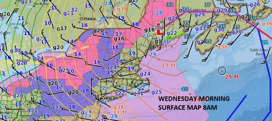
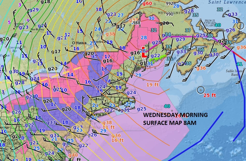
Yesterday’s major winter storm which left 1 to 2 feet of snow for most areas just inland of New York CIty continues to churn away this morning with the center up in Maine. Up to 4 feet of snow has fallen in parts of upstate NY and it is not from lake effect either. This morning we here are experiencing strong gusty winds which is blowing the snow around in areas that received a foot or more of snow and where sleet was not a big issue. Winter Weather Advisories are in effect for a few counties in Northwest New Jersey and much of Northeast Pennsylvania for restricted visibility in snow and blowing snow which should last for a good portion of the day. We also can see clouds swinging around from the storm across NY State and Pennsylvania and that will limit the sunshine considerably. Temperatures will not get out of the 20s. Snow showers will develop and pass through in a few places and could whiten up the ground in spots.
SATELLITE LOOP

REGIONAL RADAR

LOCAL RADAR NEW YORK CITY

LOCAL RADAR PHILADELPHIA


We will start to see activity pick up on the radar as we go through the day. Another cold and somewhat windy night is ahead with lows in the teens. Thursday we should see more sunshine and few clouds with less wind as highs climb back into the 30s. Friday we could see temperatures make a run for (gasp!) 40 with sunshine giving way to late day arriving clouds. The next weather system will arrive for Saturday and weather models are showing that it should be nothing but a simple warm front though the European model shows something different. We will address this later today. It does appear that the weather pattern going forward remains cold and active.
 GET JOE A CIGAR IF YOU LIKE

SNOW REMOVAL COMPANIES FOR YOUR WINTER NEEDS
LONG ISLAND ROCKLAND COUNTY Connecticut

![]()

ROCKLAND COUNTY TRI STATE SNOW REMOVAL JOHNSTOWN PA


FiOS1 News Weather Forecast For Long Island
FiOS1 News Weather Forecast For New Jersey
FiOS1 News Weather Forecast For Hudson Valley
NATIONAL WEATHER SERVICE SNOW FORECASTS
LATEST JOESTRADAMUS ON THE LONG RANGE
Weather App

Don’t be without Meteorologist Joe Cioffi’s weather app. It is really a meteorologist app because you get my forecasts and my analysis and not some automated computer generated forecast based on the GFS model. This is why your app forecast changes every 6 hours. It is model driven with no human input at all. It gives you an icon, a temperature and no insight whatsoever.
It is a complete weather app to suit your forecast needs. All the weather information you need is right on your phone. Android or I-phone, use it to keep track of all the latest weather information and forecasts. This weather app is also free of advertising so you don’t have to worry about security issues with your device. An accurate forecast and no worries that your device is being compromised.
Use it in conjunction with my website and my facebook and twitter and you have complete weather coverage of all the latest weather and the long range outlook. The website has been redone and upgraded. Its easy to use and everything is archived so you can see how well Joe does or doesn’t do when it comes to forecasts and outlooks.
Just click on the google play button or the apple store button on the sidebar for my app which is on My Weather Concierge. Download the app for free. Subscribe to my forecasts on an ad free environment for just 99 cents a month.
Get my forecasts in the palm of your hand for less than the cost of a cup of Joe!


