
DOWNLOAD MY NEW FREE JOESTRADAMUS WEATHER APP FOR ALL DEVICES
THE APP IS ABSOLUTELY FREE TO ALL BUT CONSIDERING SUBSCRIBING TO PATREON FOR A WEATHER EXPERIENCE FREE OF ADS, EXCLUSIVE VIDEOS FOR MEMBERS ONLY AND MUCH MORE…STARTS AT $2 A MONTH..MESSAGE ME AT ANY TIME
Winter Storm Watch Western Half New Jersey Eastern Pennsylvania
National Weather Service offices are hoisting Winter Storm Watches now from Western New Jersey & much of Eastern & Southern Pennsylvania southward into Maryland and Virginia. This is for Wednesday into Wednesday evening. Below is the snow forecast map from NWS from Southern New England to the Middle Atlantic. Notice that the numbers go higher as you go south, even though we are dealing with a system that is moving northward. The problem as stated on an earlier post is the cold air which begins to retreat Wednesday afternoon. This suggests that the area of snow will start to weaken as it moves northward. However areas to the south into Maryland and Virginia and to a lesser extent Southern Pennsylvania catch the more intense snow that this next storm system produces.

Since everyone forecast shops, you can check the forecast for each zone below. If you like you can compare it to my forecast which is on the low side of most of the numbers that are out there. My numbers are conservative based on the tendency for underperformance from every storm that has played out in the Northeast. This storm does however have a chance to overperform in Maryland and Virginia.
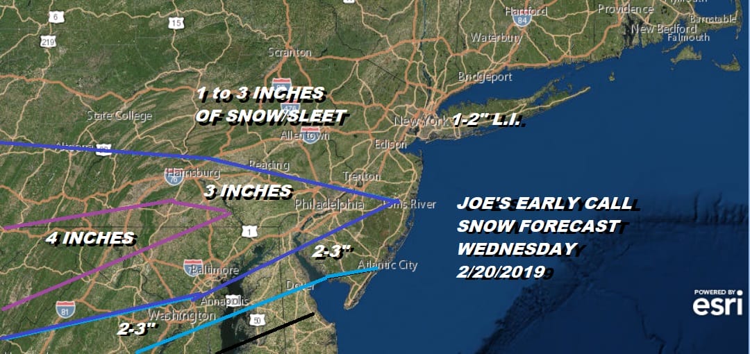
Below are the forecast maps from the various NWS offices. I have also included the any statements or watches that may have been issued for those specific zones. Be advised that a Winter Storm Watch in one zone might have different criteria regarding snow and ice amounts verses another. The criteria for Winter Storm Watches is lower as you go further south.
SNOW FORECAST MAPS
New York City, Ne NJ, HV, LI, Coastal Ct
NEW YORK CITY & VICINITY ICE

The New York City National Weather Service office zones fall out of the criteria for a Winter Storm Watch at this time. Right now the area of snow is forecast to weaken as it moves northward which puts amounts under any criteria for a Winter Storm Watch. Only a change in the forecast outlook would prompt watches to go up for these zones. Advisories are more likely and they won’t go up until later Tuesday at the earliest.
NEW JERSEY & PARTS OF NE PA

Sussex-Warren-Morris-Carbon-Monroe-Berks-Lehigh-Northampton-
Including the cities of Newton, Washington, Morristown,
Jim Thorpe, Stroudsburg, Reading, Allentown, Bethlehem,
and Easton
316 PM EST Mon Feb 18 2019
…WINTER STORM WATCH IN EFFECT FROM WEDNESDAY MORNING THROUGH
THURSDAY MORNING…
* WHAT…Heavy mixed precipitation possible. Total snow
accumulations of 3 to 5 inches and ice accumulations of around
one tenth of an inch possible.
* WHERE…Portions of northern New Jersey and east central and
northeast Pennsylvania.
* WHEN…From Wednesday morning through Thursday morning.
SOUTHERN AND SOUTHEAST NEW ENGLAND

No watches are up for this zone as any snow or wintry precipitation happens Wednesday evening and beyond so it is still far enough for this office to post watches/advisories up. Look for something from this zone later Tuesday.
CENTRAL & SOUTH CENTRAL PA

Mifflin-Juniata-Perry-Dauphin-Lebanon-Cumberland-Adams-York-
Lancaster-
Including the cities of Lewistown, Mifflintown, Newport,
Harrisburg, Hershey, Lebanon, Carlisle, Gettysburg, York,
and Lancaster
238 PM EST Mon Feb 18 2019
…WINTER STORM WATCH IN EFFECT FROM WEDNESDAY MORNING THROUGH
THURSDAY MORNING…
* WHAT…Heavy mixed precipitation possible. Total snow and sleet
accumulations of 3 to 5 inches possible. followed by potential
ice accumulations up to one quarter of inch later Wednesday
afternoon and night.
* WHERE…Portions of central Pennsylvania.
* WHEN…From Wednesday morning through Thursday morning.
VIRGINIA & MARYLAND

District of Columbia-Washington-Frederick MD-Carroll-
Northern Baltimore-Southern Baltimore-Prince Georges-Anne Arundel-
Extreme Western Allegany-Central and Eastern Allegany-
Northwest Montgomery-Central and Southeast Montgomery-
Northwest Howard-Central and Southeast Howard-Northwest Harford-
Southeast Harford-Augusta-Rockingham-Shenandoah-Frederick VA-Page-
Warren-Clarke-Nelson-Albemarle-Greene-Madison-Rappahannock-Orange-
Culpeper-Prince William/Manassas/Manassas Park-Fairfax-
Arlington/Falls Church/Alexandria-Stafford-Spotsylvania-
Northern Fauquier-Southern Fauquier-Western Highland-
Eastern Highland-Western Loudoun-Eastern Loudoun-
Northern Virginia Blue Ridge-Central Virginia Blue Ridge-
Hampshire-Morgan-Berkeley-Jefferson-Hardy-Western Grant-
Eastern Grant-Western Mineral-Eastern Mineral-Western Pendleton-
Eastern Pendleton-
126 PM EST Mon Feb 18 2019
…WINTER STORM WATCH REMAINS IN EFFECT FROM TUESDAY EVENING
THROUGH WEDNESDAY EVENING…
* WHAT…Heavy snow, mixing with and eventually changing to
sleet and then freezing rain. Snow accumulations of 5 or more
inches and ice accumulations of a quarter-inch or greater are
possible.
* WHERE…The District of Columbia, Maryland east of the
Alleghany Front and west of the Chesapeake Bay, central and
northern Virginia, and the eastern West Virginia panhandle.
* WHEN…From Tuesday evening through Wednesday evening.
SNOW FORECAST MAPS ACROSS THE SOUTH
WESTERN VIRGINIA INTO WESTERN NORTH CAROLINA
…Expect wintry weather to impact the area late Tuesday
afternoon into late Wednesday…
.A strong area of high pressure will shifts east into the
Northeast United States, this will result in cold air wedging
down the Appalachians. As a winter storm lifts northeast across
our region, precipitation will spread north over this shallow
dome of cold air, producing a wintry mixture of snow, sleet and
freezing rain.
VAZ014-017-018-022-032-033-WVZ044-190445-
/O.UPG.KRNK.WS.A.0003.190219T2100Z-190220T2300Z/
/O.NEW.KRNK.WS.W.0003.190219T2300Z-190221T0100Z/
Montgomery-Floyd-Craig-Roanoke-Patrick-Franklin-Monroe-
Including the cities of Blacksburg, Floyd, New Castle, Roanoke,
Salem, Stuart, Rocky Mount, and Union
333 PM EST Mon Feb 18 2019
…WINTER STORM WARNING IN EFFECT FROM 6 PM TUESDAY TO 8 PM EST
WEDNESDAY…
* WHAT…Heavy mixed precipitation expected. Total snow and sleet
accumulations of up to 3 inches and ice accumulations of one
tenth to two tenths of an inch expected.
* WHERE…Portions of southwest and west central Virginia and
southeast West Virginia.
* WHEN…From 6 PM Tuesday to 8 PM EST Wednesday.
I have only included the maps where winter precipitation is likely at this point. Others either have no snow in their forecasts or the maps have not been updated to include this next weather event. Check your local National Weather Service office for the latest information.
DAILY NORTHEAST SNOWFALL

MANY THANKS TO TROPICAL TIDBITS FOR THE USE OF MAPS
Please note that with regards to any tropical storms or hurricanes, should a storm be threatening, please consult your local National Weather Service office or your local government officials about what action you should be taking to protect life and property.