
Winter Storm Warnings East of NYC Winter Weather Advisory West & North
Winter Storm Warnings East of NYC
Winter Weather Advisory West & North
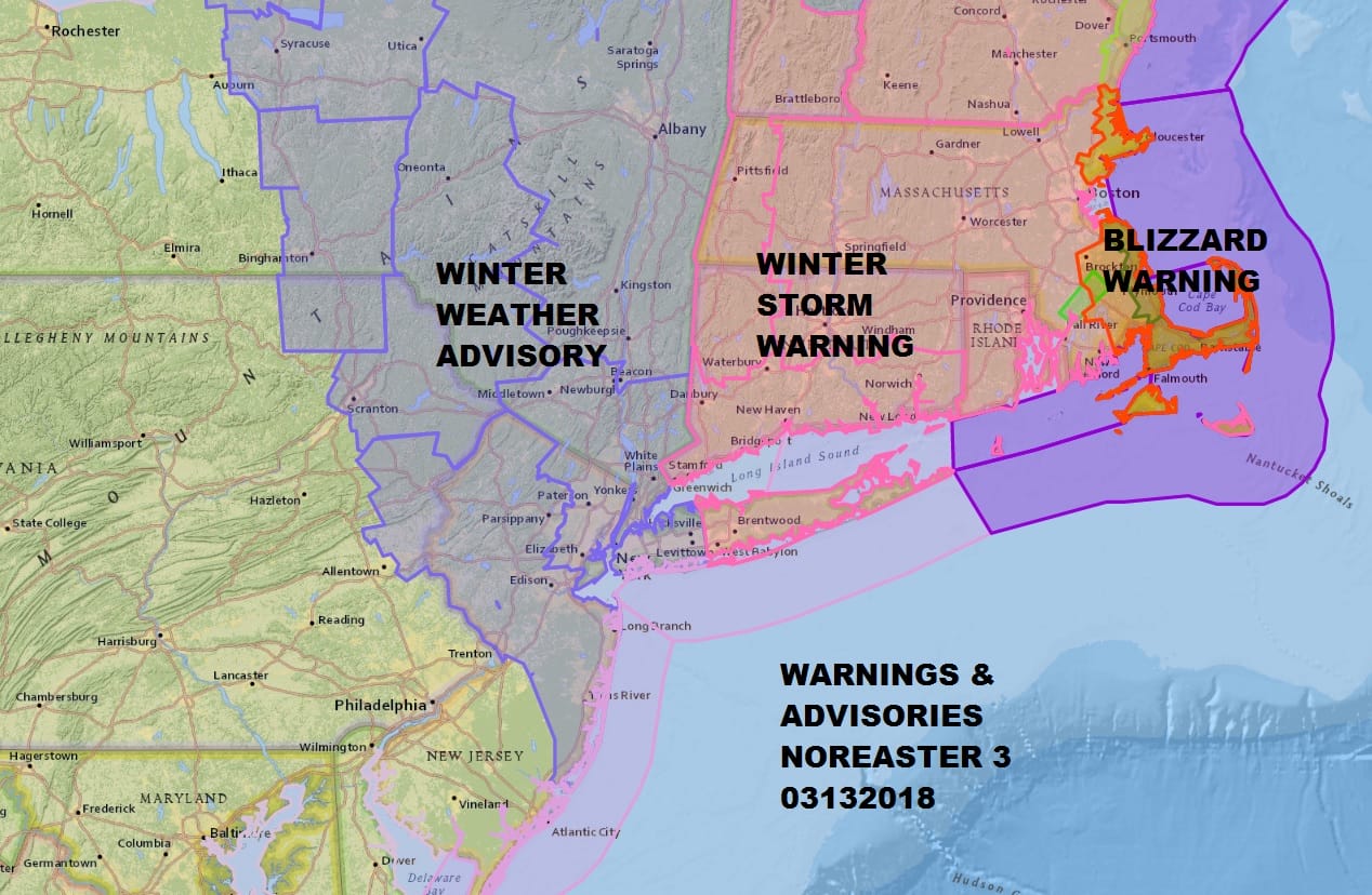
Winter Storm Warnings continue for Suffolk County on Long Island and all of Connecticut. Winter Weather Advisory is in effect for the Northern Half of New Jersey as well as Ocean County and Northeastern Pennsylvania. There have been no important changes in the outlook late this afternoon. Weather models have been relatively consistent and holding their own. Satellite and radars showing the coastal low near the North Carolina coast is loading up rather quickly. In fact the radar seems to be busy in places that models didn’t catch early.
US SATELLITE

REGIONAL RADAR

LOCAL RADAR NEW YORK CITY

LOCAL RADAR PHILADELPHIA


Look for some light rain or snow to break out across the area later this evening and then once precipitation gets heavy enough it falls as all snow overnight into the Tuesday morning commute. What keeps us from getting hammered with heavy snow is that the surface low is forecast to track east before turning northward as opposed to just running straight northeast to get to the same point southeast of Cape Cod Tuesday morning. The broad track offshore vs the tighter track closer to the coast makes a huge difference in snow totals.
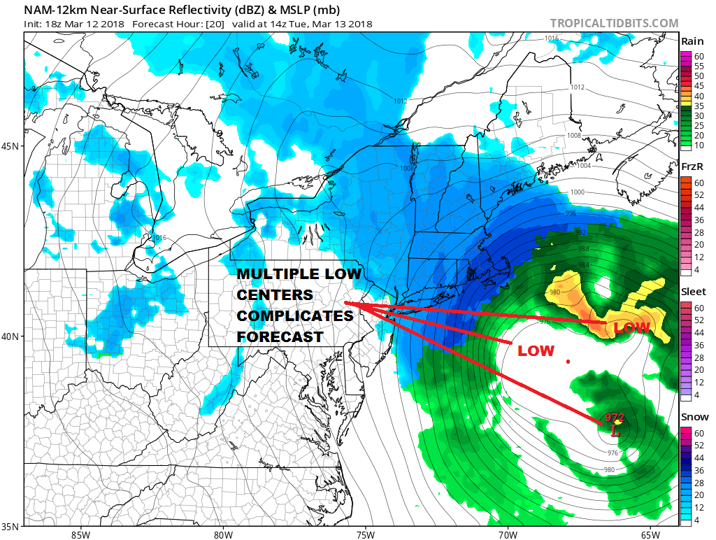
One of the big forecast problems is that some of the short term models are showing multiple low centers which distorts the precipitation field considerable. This is likely to create some volatility in snow amounts depending which center is truly the dominant one. This is something that we will be paying attention to very closely overnight. If the western most low center dominates it could increase snow amounts to the west. Of course the opposite happens if the dominant low is further east.
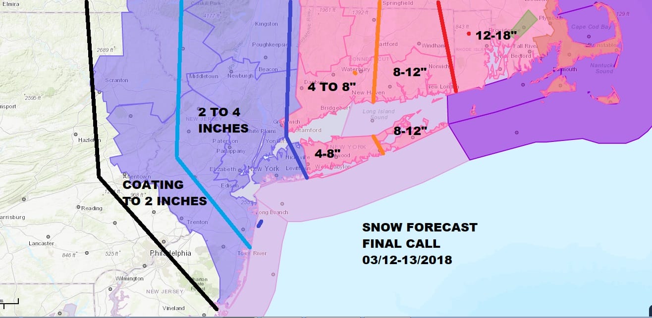
The bulk of the snow falls between midnight and 10am Tuesday. There should be snow on the ground for the morning commute. Once we get to about 10am the sun angle will cut down the additional snow accumulation. It all ends from west to east during the late morning to early afternoon. Weather conditions improve on Wednesday with sunshine and clouds and a passing snow shower. Colder than average temperatures continue all week.
 GET JOE A CIGAR IF YOU LIKE

FiOS1 News Weather Forecast For Long Island
FiOS1 News Weather Forecast For New Jersey
FiOS1 News Weather Forecast For Hudson Valley


