Winter Storm Warning Maryland to Most of Northern New Jersey
Advisories NYC Long Island Hudson Valley Connecticut

Weather in 5/Joe & Joe Weather Show Latest Podcast
Winter Storm Warning Maryland to Most of Northern New Jersey
Advisories NYC Long Island Hudson Valley Connecticut
Winter Storm Warnings are now up over a large area of the Eastern US from Northern North Carolina, up the I-95 and I-81 corridors. most of New Jersey, South Central and Southeastern Pennsylvania, Winter Weather Advisories are up for the Lower Hudson Valley, Northeast and Northwest Jersey, NYC Long Island, and much of Southern Connecticut.

The reason the areas under the advisory are not under a warning is because the snow will be spread over 2 days and does not meet the winter storm warning criteria according to the National Weather Service. (I don’t make the rules).
SATELLITE

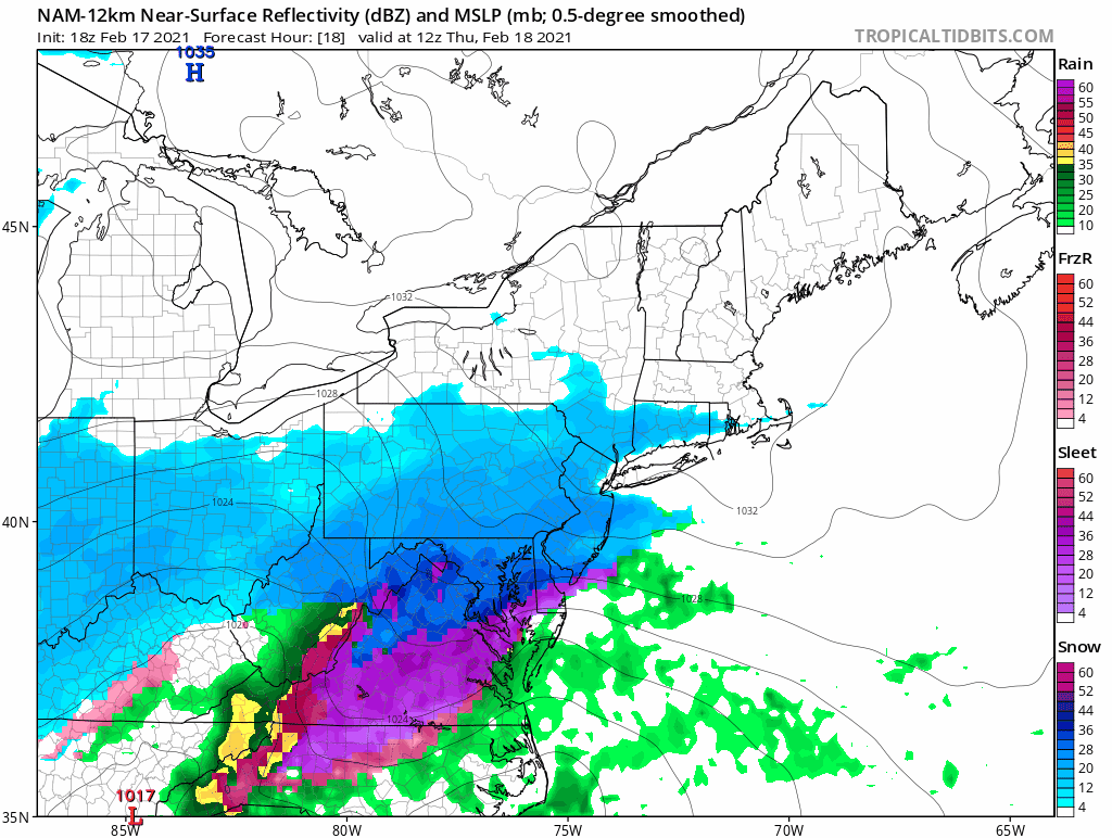
Clouds will begin rolling in tonight as temperatures head down to the upper teens and lower 20s by morning. We can see the clouds on the satellite to the west and southwest. Radars are quiet this evening but they will rev up fast overnight. Snow will reach South Central and Southeastern Pennsylvania before daybreak and reach New Jersey, NYC, the Hudson Valley, Southern New England and Long Island shortly after that.
F5 WEATHER RADARS


During Thursday morning heavy snow bands will develop as snow moves northeast and overspreads the area. The heavier snow should last about 6 hours or so and from this we should see most area pick up a quick 4 or 5 inches. After the heavy snow bands go by the snow will lighten up. However the situation is complicated by a second wave which will develop later Thursday night into Friday morning.
This is a little unusual because usually we are one and done with these systems. The upper support is lagging behind the lead system which allows a second wave to develop. From this another couple of inches should fall bringing the average total to around 6 or so in most places Friday morning.
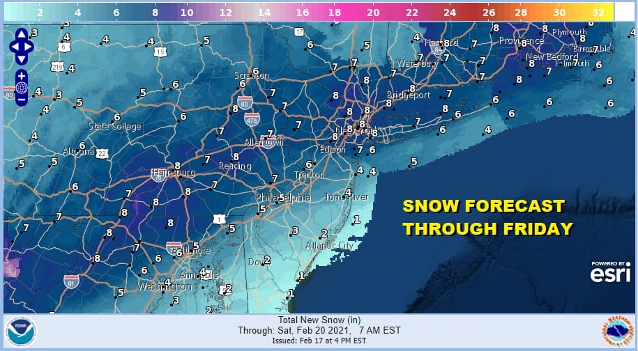
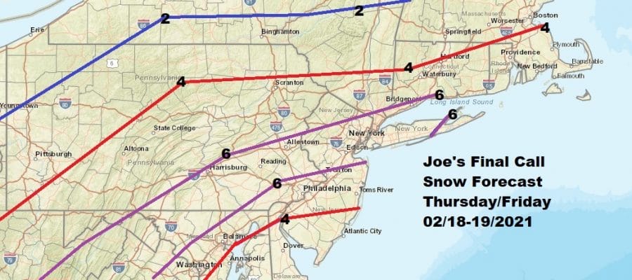
The map above is the forecast snow totals over 2 days from the National Weather Service. The map below is my final call snow forecast map for the next 2 days.

Temperatures Thursday will be in the 20s. We could rise close to 32 Thursday night and probably hold near 30 during the day Friday until the snow exits later in the day. The weekend will be very cold but dry with sunshine for both Saturday and Sunday. Saturday’s highs will be in the upper 20s to near 30. Sunday’s highs will be in lower 30s.
BE SURE TO DOWNLOAD THE FREE METEOROLOGIST JOE CIOFFI WEATHER APP &
ANGRY BEN’S FREE WEATHER APP “THE ANGRY WEATHERMAN!

MANY THANKS TO TROPICAL TIDBITS & F5 WEATHER FOR THE USE OF MAPS
Please note that with regards to any severe weather, tropical storms, or hurricanes, should a storm be threatening, please consult your local National Weather Service office or your local government officials about what action you should be taking to protect life and property.


