Windy Saturday Snow Sunday Night Into Monday
Windy Saturday Snow Sunday Night Into Monday
A storm in Eastern Canada is strengthening this morning which is tightening the pressure gradient and creating some gusty winds across the area. Some gusts have reached 40 mph at times this morning. Look for the winds to continue to be gusty into this afternoon before settling down a bit. Temperatures are in the 40s and are likely to hold in the 40s as colder air comes down later today.

No weather issues to speak of on satellite or on radar loops this morning as all is quiet to the north west and nearby south. However we can see moisture beginning to move out of the Gulf States and heading northeastward. No issues tonight and Sunday with clear skies tonight and sunshine for most of Sunday. Lows tonight will be in the upper 20s and lower 30s and Sunday’s highs will be in the low to middle 40s.


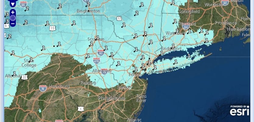
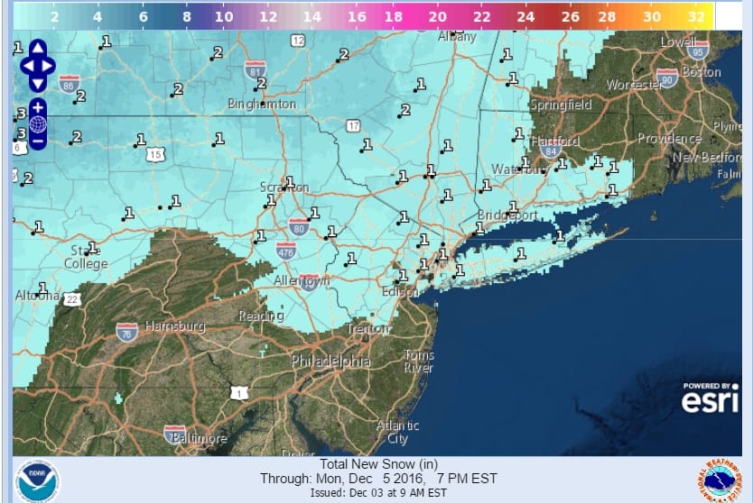
The lead moisture from the system in the Gulf will produce a period of snow here later Sunday night into Monday morning. There is enough moisture here for a cheap thrill snowfall of a coating to an inch or so especially in elevated areas. Flakes could fly even in some of the usually warmer urban centers as well. The snow should be done during the morning and then weather conditions improve after that.
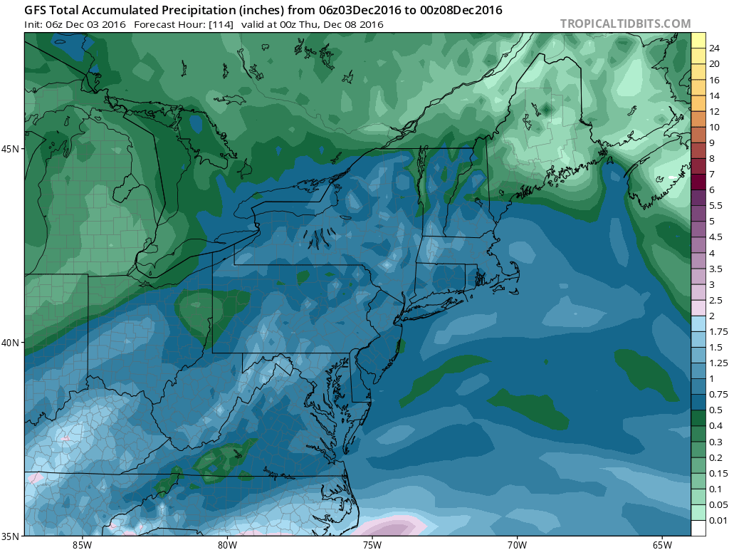
Tuesday brings a second and stronger low up the coast with a cold rain developing and that could begin as snow inland if it comes in fast enough. In fact in some of the elevated areas north and west of the coast there could be a front end dump with this system. Rainfall will also be significant on the order of three quarters of an inch to an inch which chips away at the drought a bit more.
Long range we see the arrival of very cold air late next week and the question is whether there will be a round of rain or rain changing to snow on Thursday of next week before the cold air settles in. Long range models have a cold wintry look to them over the next few weeks and we will explore that more later today.
SNOW REMOVAL COMPANIES FOR YOUR WINTER NEEDS
LONG ISLAND ROCKLAND COUNTY Connecticut

![]()

FiOS1 News Weather Forecast For Long Island
FiOS1 News Weather Forecast For New Jersey
FiOS1 News Weather Forecast For Hudson Valley
NATIONAL WEATHER SERVICE SNOW FORECASTS
LATEST JOESTRADAMUS ON THE LONG RANGE
Weather App

Don’t be without Meteorologist Joe Cioffi’s weather app. It is really a meteorologist app because you get my forecasts and my analysis and not some automated computer generated forecast based on the GFS model. This is why your app forecast changes every 6 hours. It is model driven with no human input at all. It gives you an icon, a temperature and no insight whatsoever.
It is a complete weather app to suit your forecast needs. All the weather information you need is right on your phone. Android or I-phone, use it to keep track of all the latest weather information and forecasts. This weather app is also free of advertising so you don’t have to worry about security issues with your device. An accurate forecast and no worries that your device is being compromised.
Use it in conjunction with my website and my facebook and twitter and you have complete weather coverage of all the latest weather and the long range outlook. The website has been redone and upgraded. Its easy to use and everything is archived so you can see how well Joe does or doesn’t do when it comes to forecasts and outlooks.
Just click on the google play button or the apple store button on the sidebar for my app which is on My Weather Concierge. Download the app for free. Subscribe to my forecasts on an ad free environment for just 99 cents a month.
Get my forecasts in the palm of your hand for less than the cost of a cup of Joe!


