Windy Cold Weekend Snow Monday Night Into Tuesday From Weak Storm
Weather in 5/Joe & Joe Weather Show Latest Podcast
Windy Cold Weekend Snow Monday Night Into Tuesday From Weak Storm
This is probably the coldest weather and certainly the coldest weekend of the winter season so far. Temperatures are going no where today. Most highs will be in the upper 20s and lower 30s. Let’s throw in a gusty wind of 20 to 30 mph especially along the coast and you have the makings of a very cold day as well as a very cold night ahead.
SATELLITE
We are still seeing some bands of cloud cover as well as a few bands of snow showers moving southeast from Upstate NY and Pennsylvania but these bands are weak and aren’t about to produce very much of anything snow wise. I don’t expect the bands to make it to the coast.
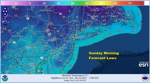
Tonight will be very cold indeed with clear skies and there will still be a bit of a wind especially at the coast. By morning lows will be in the teens. Wind chills will be in the single digits to near zero making for a very cold Sunday morning.
Sunday will be another cold day but the winds will ease and the temperatures should make it to the low and middle 30s with sunshine. Then we move on to the new week with not one but two storm systems headed into the Eastern US.
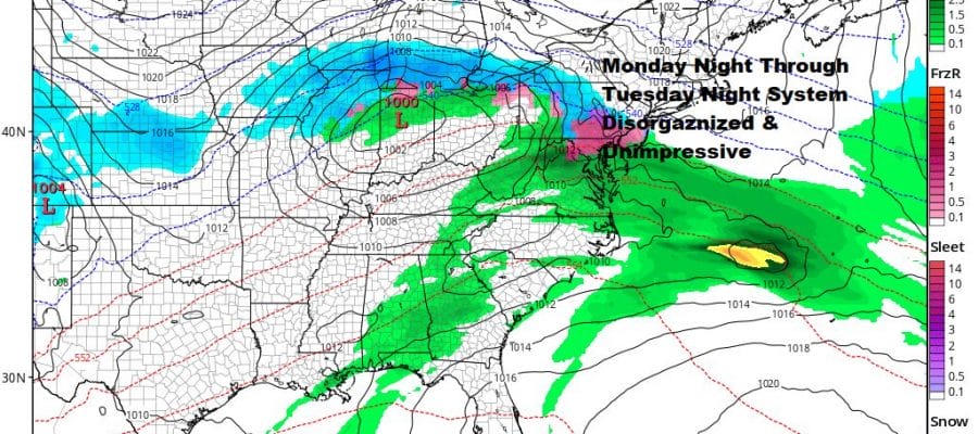
Monday begins the approach of the first of two storm systems. I am completely underwhelmed by the first one. Low pressure heads into the Ohio Valley and you will notice the long east west stretch of precipitation on the GFS radar depiction above. The primary low goes so far west and the secondary reforms so far to the east of the coast that it takes most of the heavy precipitation out to sea. It is hard to imagine that we get much from this storm system if the upper support is so weak. Snow should develop from south to north Monday evening or overnight but note the sharp cut off just north and east of NYC. For now we are thinking on the order of a coating to a couple of of inches at most for Eastern Pennsylvania to NYC to Long Island. There may be little of consequence north and west of these points. Across Southern Pennsylvania there could be a band of several inches if the snow holds together on the radar along with perhaps some sleet or freezing rain. The dying primary low will keep us in precipitation on and off Tuesday into Tuesday night. Across Southern Pennsylvania there could be a band of several inches if the snow holds together on the radar along with perhaps some sleet or freezing rain. The dying primary low will keep us in precipitation on and off Tuesday into Tuesday night.
One system leaves and here comes the next one coming out of the Lower Tennessee Valley and Southeast US. Low pressure moves into the Tennessee Valley and redevelops along the Virginia Capes. This primary secondary low has a lot of upper air support and there is the likelihood that this system becomes a major storm out in the ocean. Not only do we see more support but this has a chance to move a little further north if the blocking pattern to the east relaxes somewhat. This has the potential to produce a big snowfall in the Mid Atlantic states for places like Baltimore and Washington DC where there has been a snow drought for much of the past several years. For now the GFS and some other models bring heavier snows into Southern New Jersey with a cutoff around NYC and Long Island. The first system will have a say in the outcome of the second as well as the block to the northeast. We have lots of time to watch this.
We will be doing an early call snow forecast map for the system on Patreon later today.
BE SURE TO DOWNLOAD THE FREE METEOROLOGIST JOE CIOFFI WEATHER APP &
ANGRY BEN’S FREE WEATHER APP “THE ANGRY WEATHERMAN!
MANY THANKS TO TROPICAL TIDBITS FOR THE USE OF MAPS
Please note that with regards to any severe weather, tropical storms, or hurricanes, should a storm be threatening, please consult your local National Weather Service office or your local government officials about what action you should be taking to protect life and property.


