Wind Advisory Howling Northwest Winds
Very Cold Friday Snow Sleet Rain Saturday
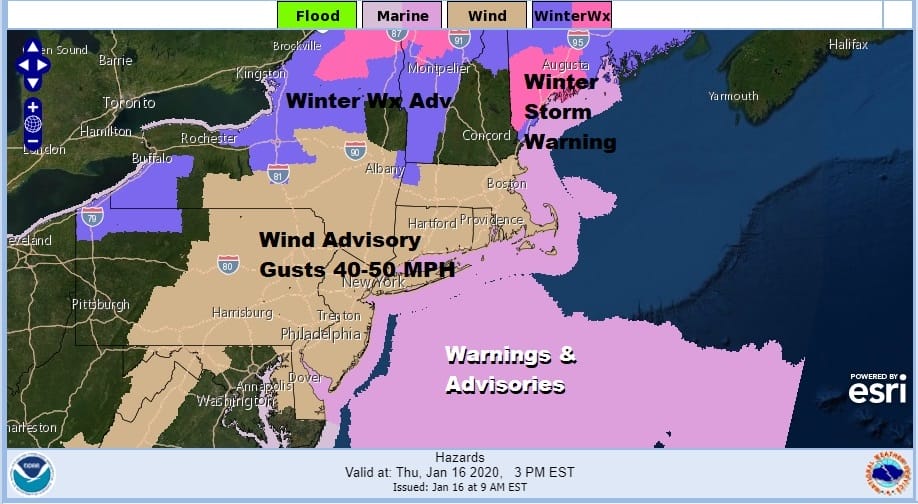
Wind Advisories are posted today into this evening and you can thank a strengthening storm this morning that is moving off the coast of Southeastern New England. Combine that with a strong high with bitter cold air in the Northern Plains and you have the set up for northwest winds of 20 to 35 with gusts over 40 mph at times. Temperatures are in the 40s. We do have some sun in the mix but colder air is coming for the next 2 days.
SATELLITE

REGIONAL RADAR

Regional radar is showing busy conditions across upstate NY and Northern New England today with snow. Lake effect snows are moving southeastward into Western NY and Northwestern Pennsylvania. There could still be a stray rain or snow shower this afternoon as colder air continues to arrive.
LOCAL RADAR NEW YORK CITY

LOCAL RADAR PHILADELPHIA


Skies will clear out tonight with Friday morning lows mostly in the 20s. Then for the daytime Friday it will still be windy in the morning before winds ease in the afternoon. We should have plenty of sunshine with highs just in the mid 20s to lower 30s at best. Then a very cold night Friday night with clear skies and most lows in the teens to some single digits north and west of the coast.

Saturday low pressure moves east across the Great Lakes. A warm front will be pushing toward us and there will be some snow. This morning’s NAM model basically breaks this down to a 4 to 6 hour period of snow to sleet to rain. The loop above runs from 7am to 7pm. It doesn’t look all that impressive to me and cold air will be pulling out. It will be a matter of how impressive is the radar Saturday morning and how long does the cold air hang on.
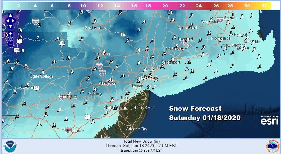
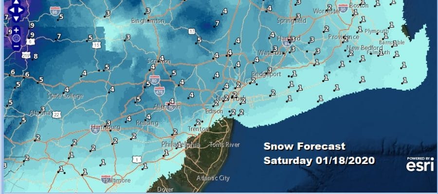
These are some of the numbers the National Weather Service is going with. A coating to 2 inches near the coast and 2 to 4 inches inland. This seems reasonable but it will all hinge on whether that warm front is as active as some models suggest. All of this is over with by Saturday evening in most places and probably ends as rain in many areas. Colder drier weather returns on Sunday. The long range weather pattern has flipped to cold. Next week will be very cold all week with below average temperatures each day. It will be a dry week until next weekend when we have models signalling at a more important storm impacting the Eastern US.
My snow forecast is available on my FREE weather app which you can download on google play or on the app store.
BE SURE TO DOWNLOAD THE FREE METEOROLOGIST JOE CIOFFI WEATHER APP &
ANGRY BEN’S FREE WEATHER APP “THE ANGRY WEATHERMAN!
MANY THANKS TO TROPICAL TIDBITS FOR THE USE OF MAPS
Please note that with regards to any severe weather, tropical storms, or hurricanes, should a storm be threatening, please consult your local National Weather Service office or your local government officials about what action you should be taking to protect life and property.


