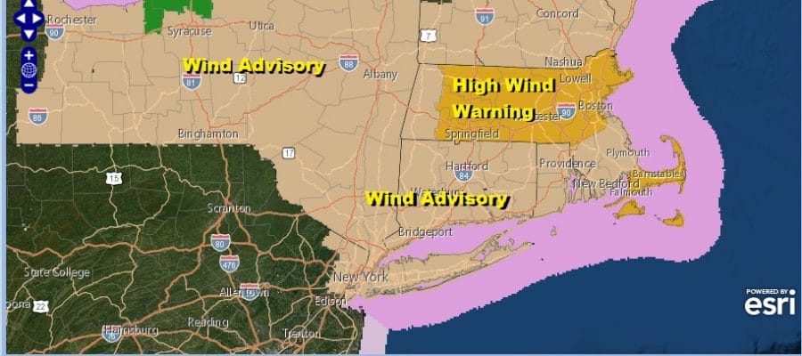
Wind Advisory Gusts 40 to 50 MPH Chilly Thursday Friday Hurricane Delta And The Weekend
WEATHER IN 5 WEDNESDAY OCTOBER 7, 2020
We have a warm day ahead of us. To the northwest we see clouds and that is the next cold front that will be moving quickly through the area this afternoon. We aren’t expecting much with that weather front other than some clouds however we have a strong upper trough and strong winds aloft. It is likely that some of those gusty winds will mix down to the surface and that justifies the Wind Advisory that has been posted.

Winds are likely to gust to 40 to 50 mph, The strongest winds will be from Northern New Jersey north and east and a HIgh Wind Warning is up for much of Massachusetts. South and west of the advisory area it will be a bit on the breezy side today with gusts to 30 mph or so but that is below wind advisory criteria. Temperatures today will top out in the mild low and middle 70s. Radar is showing showers in Western NY. Those showers and eventually a few thunderstorms will move across upstate NY and Central and Northern New England but there won’t be much on the southern end of this othet than a passing sprinkle or shower.
SATELLITE

REGIONAL RADAR

Skies will clear out tonight with lows in the 40s to lower 50s in warmer urban settings and a long the coast. Thursday will be a sunny breezy day with highs in the 60s. That takes us to Thursday night into Friday morning which will be clear and chilly. Inland lows will be in the 30s with coast and urban centers in the low to mid 40s.
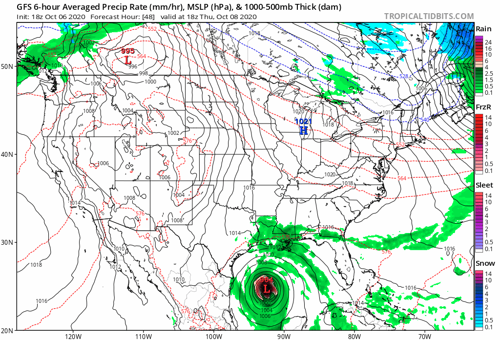
The next high is going to move out faster so temperatures will bounce Friday back to the mid 60s to near 70 with lots of sunshine. We will warm up further on Saturday with sunshine with highs in the low to mid 70s. Another cold front comes through Saturday night with not much weather. However that high sets up the remnant rains of Hurricane Delta. We expect a landfall along the Louisiana coast Friday evening and then a move north and northeastward. Weather models are indicating rain arriving here later Sunday night so Sunday dayside should be rain free for most of the area with increasing and thickening clouds along with an ocean wind. Rain arrives in Southern New Jersey to Southern Pennsylvania Sunday evening and then spreads northward during Sunday night into Monday. The GFS pains a bullish 1 to 2 inches of rain from this. Other models are slower and further west with the rain area. The speed of Delta likely depends on how stronger it gets because the stronger it gets before landfall the faster it moves. This could effect the timing of the arrival of any rain here but for now it seems that we are okay through Sunday daytime.
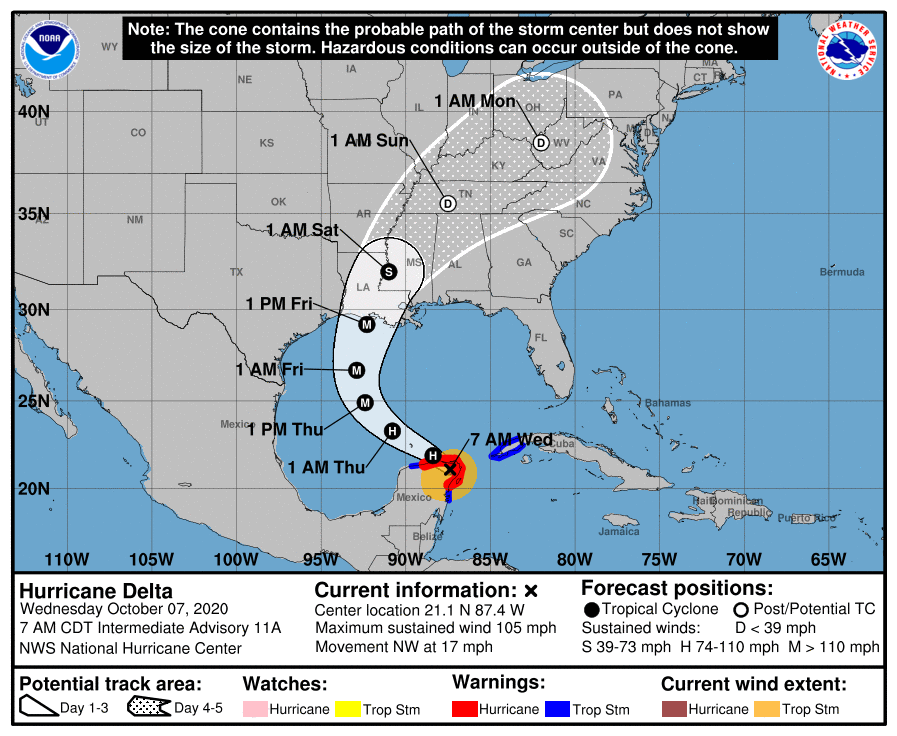
After strengthening rapidly yesterday we saw some weakening of Delta before it made landfall this morning over the Northeast Yucatan Peninsula. Delta will emerge from there into the Gulf of Mexico this afternoon and conditions are favorable for strengthening. However the weakening last night was unexpected and not forecast by most of the hurricane models. The National Hurricane Center often says that while track forecasts have gotten very good, intensity determination is a different matter. None the less conditions are favorable for Delta to become a major hurricane again in the Gulf of Mexico and hopefully it weakens a bit before a Louisiana landfall Friday evening. The hurricane’s circulation will expand as it moves northward which will mean storm surge issues though thankfully we are at the mid point of the lunar cycle which helps to mitigate high tides to an extent.
BE SURE TO DOWNLOAD THE FREE METEOROLOGIST JOE CIOFFI WEATHER APP &
ANGRY BEN’S FREE WEATHER APP “THE ANGRY WEATHERMAN!
MANY THANKS TO TROPICAL TIDBITS FOR THE USE OF MAPS
Please note that with regards to any severe weather, tropical storms, or hurricanes, should a storm be threatening, please consult your local National Weather Service office or your local government officials about what action you should be taking to protect life and property.


