Wind Advisory Continues Into Early Thursday Morning. Chilly Into Friday Morning
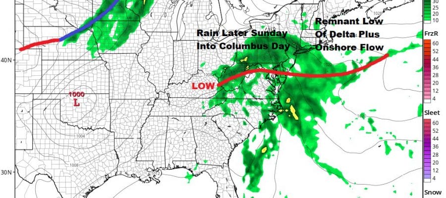
Rain Likely Late Sunday Into Monday
WEATHER IN 5 WEDNESDAY OCTOBER 7, 2020

Our cold front has moved through and we had some scary looking skies with a few showers this evening. Thunderstorms, some severe, were common in upstate NY and parts of New England which is unusual for October, That is just about done now and we should clear out tonight. Lows by morning will be in the 50s along the coast and in warmer urban settings with 40s well inland.
SATELLITE

REGIONAL RADAR

All of the showers and thunderstorms are no offshore on the radar which will now go quiet for the next several days. Thursday we will see sunshine breezy and cool conditions with highs in the 60s. Then we head south Thursday night into Friday morning under clear skies. Lows will be in the 30s with low to mid 40s coast and the big cities. Friday looks nice and sunny with highs bouncing back to the upper 60s to some lower 70s.

Saturday will be the best day of the holiday weekend. Look for sunshine and warm conditions with highs in the low to mid 70s. A cold front will come through Saturday night with nothing more than some clouds but it sets up the onshore flow Sunday and Monday. Then we will see the remnant low of Hurricane Delta bring rain here later Sunday into Monday. This could wind up being a nice soaking rain of an inch or two total. Too bad it comes on a holiday weekend. Next week will see another weather system approaching which means we could see showers linger into Tuesday and possibly even Wednesday as another front passes.


