
Welcome to A Gloom And Doom Weekend 2 Inches of Rain Likely In to Sunday

Welcome to A Gloom And Doom Weekend 2 Inches of Rain Likely In to Sunday
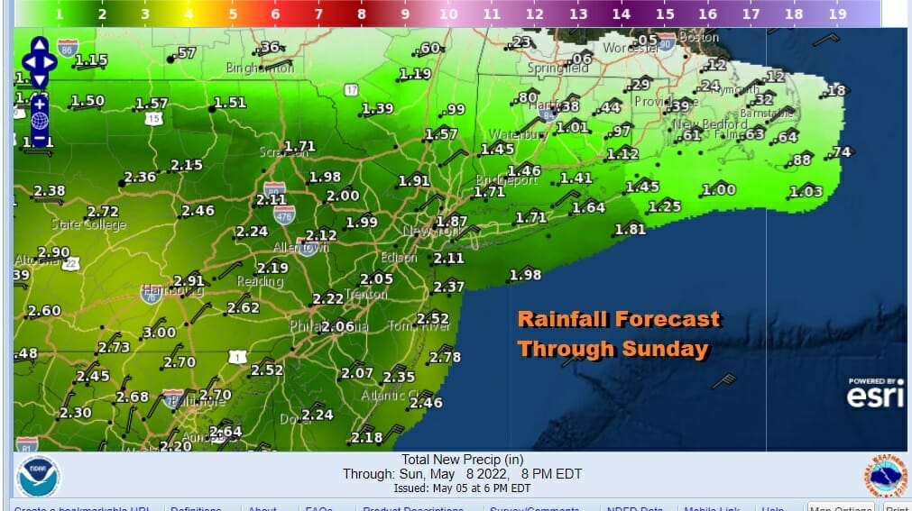
Here we are back in the land of gloom and doom. Rain has already overspread the area from west to east. We have gale warnings in effect for the coastal waters as winds start to pick. Coastal flood watches are up for the coastal counties of New Jersey for flooding at high tide though at least we are at the low point in the lunar cycle. Low pressure is tracking across the lower Ohio Valley. It will cross the Central Appalachians and eventually redevelop along the Mid Atlantic Coast over the weekend. It is a slow process that is going to take several days to play out. In the meantime as far as rainfall is concerned we are looking at the potential for 2 inches plus for most of the area and we will likely see some localized flooding in the usual suspect spots.
SATELLITE

WEATHER RADAR

Now that the rain is here and the winds start to slowly pick up from the northeast, expect temperatures to settle in the 50s and possibly into the upper 40s and lower 50s right into Sunday morning. It is going to be a raw damp wet stretch. Winds will become gusty Saturday into Sunday from the northeast to east reaching gale force along the coast but I’m not expecting big winds inland.

This is what happens in a blocking pattern where storms are not able to take their normal paths from west to east. We know it rains into Saturday night before the rain tapers off into Sunday morning. The problem for Sunday is that the low is close by and as it rotates it risks bringing rain back into the coast from the east. Even if that doesn’t happen it will be a gloom and doom day with highs mostly in the 50s to lower 60s inland.

Starting Monday the low offshore should start to slowly drop southward but how and where will make a difference. I think we will be fighting the onshore flow through Tuesday meaning that while rain may not be an issue, clouds probably will be. We will still need to be cautious for patches of rain backing westward into the coast especially on Monday. Once the rain stops we should see temperatures claw their way back into the 60s. Meanwhile well inland int Western and Northern NY and into Eastern Canada, a ridge builds there and sends temperatures climbing into the 80s in those areas by mid week. If we can get this low out of the way or far enough south, we could benefit from better weather and warmer temperatures later next week.
BE SURE TO DOWNLOAD THE FREE METEOROLOGIST JOE CIOFFI WEATHER APP &
ANGRY BEN’S FREE WEATHER APP “THE ANGRY WEATHERMAN!
MANY THANKS TO TROPICAL TIDBITS & F5 WEATHER FOR THE USE OF MAPS
Please note that with regards to any severe weather, tropical storms, or hurricanes, should a storm be threatening, please consult your local National Weather Service office or your local government officials about what action you should be taking to protect life and property.


