Weekend Weather Outlook Sunshine Warm Thunderstorms
Weekend Weather Outlook Sunshine Warm Thunderstorms
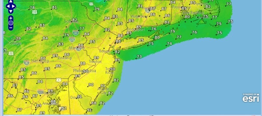
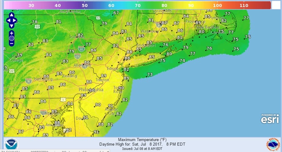
We have the weekend underway and there is still a little bit of work to do today. There is a weather front that will be moving through late this afternoon which might trigger off an isolated shower or thunderstorm. Other than that we should see a mix of sun and clouds today with temperatures in the mid 80s to near 90. The front marks the leading edge of a low humidity air mass. The dry air from that air mass is already in the Western Great Lakes and pushing toward us. This will make for a beautiful Sunday with plenty of sunshine, low humidity, and temperatures in the 80s.
SATELLITE LOOP

REGIONAL RADAR

Regional radar shows showers and thunderstorms from the cold front in Western and Northern NY moving eastward. The bulk of the thunderstorms with this front will pass well to our north.
LOCAL RADAR NEW YORK CITY

LOCAL RADAR PHILADELPHIA


Monday starts nice and dry but we may see clouds arriving later in the day and the chance for a shower or thunderstorm Monday night as the next warm front cold front combination approach. Temperatures Monday will be in the 80s. Tuesday we will see clouds and sun and the chance for late showers and thunderstorms with highs in the 80s to near 90. Then it is a little less humid for Wednesday and then its the next warm front cold front combination for the end of the week. The pattern remains active where fronts are coming through every couple of days so it can’t get too hot for too long.
 GET JOE A CIGAR IF YOU LIKE

LANDSCAPE COMPANIES FOR YOUR NEEDS
LONG ISLAND ROCKLAND COUNTY Connecticut

![]()

ROCKLAND COUNTY TRI STATE SNOW REMOVAL JOHNSTOWN PA


FiOS1 News Weather Forecast For Long Island
FiOS1 News Weather Forecast For New Jersey
FiOS1 News Weather Forecast For Hudson Valley
NATIONAL WEATHER SERVICE SNOW FORECASTS
LATEST JOESTRADAMUS ON THE LONG RANGE
Weather App

Don’t be without Meteorologist Joe Cioffi’s weather app. It is really a meteorologist app because you get my forecasts and my analysis and not some automated computer generated forecast based on the GFS model. This is why your app forecast changes every 6 hours. It is model driven with no human input at all. It gives you an icon, a temperature and no insight whatsoever.
It is a complete weather app to suit your forecast needs. All the weather information you need is right on your phone. Android or I-phone, use it to keep track of all the latest weather information and forecasts. This weather app is also free of advertising so you don’t have to worry about security issues with your device. An accurate forecast and no worries that your device is being compromised.
Use it in conjunction with my website and my facebook and twitter and you have complete weather coverage of all the latest weather and the long range outlook. The website has been redone and upgraded. Its easy to use and everything is archived so you can see how well Joe does or doesn’t do when it comes to forecasts and outlooks.
Just click on the google play button or the apple store button on the sidebar for my app which is on My Weather Concierge. Download the app for free. Subscribe to my forecasts on an ad free environment for just 99 cents a month.
Get my forecasts in the palm of your hand for less than the cost of a cup of Joe!


