FINALLY COOLER AIR ARRIVES OVER THE WEEKEND
CLOUDS WILL BE STUBBORN WITH A NORTHEAST WIND
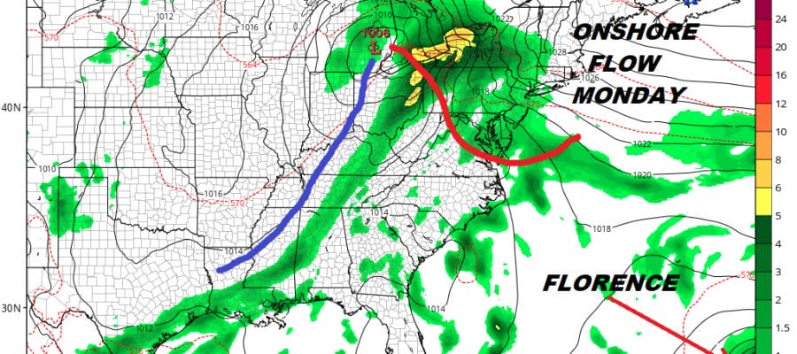
FLORENCE TURNING WESTWARD. SHOULD RESTRENGTHEN THIS WEEKEND
After what was probably the most oppressive day of the summer with heat indices approaching 110, we are finally at the end of this recent stretch of horrible heat and humidity. Thunderstorms last night came through with the cold front with numerous lightning strikes across the area. Now we can watch things calm down somewhat as the front settles to the south and high pressure begins to build southward from the Great Lakes & Eastern Canada.
EASTERN SATELLITE

REGIONAL RADAR

We are going to be dealing with clouds for most of the next several days which will also put a cap on temperatures. Some passing showers could show up on the radar at times given the proximity of the front to the south but most of the day should be dry. Temperatures today won’t get out of the 70s.
LOCAL RADAR NEW YORK CITY

LOCAL RADAR PHILADELPHIA


A weak wave on the front could bring a little rain overnight into Saturday morning but the dry air to the north will attempt to bleed southward. I would not be surprised to see some breaks of sun develop over the weekend with Sunday likely being the better of the two weekend day but also the coolest. Highs will be in the low to mid 70s on Saturday and in the 60s to near 70 on Sunday.

The front starts to come back northward Sunday night and Monday and there will be some showers from this as the warm front slowly pushes through. Monday’s highs will be in the 70s. Then as an upper high builds back into the Northeast we will be back to warm and humid conditions for Tuesday and Wednesday with some sunshine returns and highs back into the 80s. That upper high of course is key to Florence which by then could be nearing the Eastern Seaboard.
Florence weakened to a tropical storm last night thanks to the strong wind shear that developed. This also turned the weaker storm to the west which is very important regarding its position in the long term. The next hurdle Florence will attempt to jump is the trough in the upper atmosphere. All indications are that Florence will miss this weakness and continue westward toward the US East Coast. We are also beginning to see a tightening up of various weather models regarding the track but the specifics remain rather wide in the longer term. If Florence is going to be a threat it will like be Thursday and Friday of next week. Assuming that models are correct Florence will reach 30N/70W some time Tuesday night. From here it will be anyone’s guess at this point. All options are on the table. The upper high cradling the storm will determine how far west Florence gets as it begins to gain latitude. We will examine the European and other models this morning for comparison.
MANY THANKS TO TROPICAL TIDBITS FOR THE USE OF MAPS
Please note that with regards to any tropical storms or hurricanes, should a storm be threatening, please consult your local National Weather Service office or your local government officials about what action you should be taking to protect life and property.
LATEST JOESTRADAMUS ON THE LONG RANGE


