STRONG THUNDERSTORMS DEVELOPING ON THE RADARS
SOME CELLS COULD BE SEVERE THIS EVENING & THE FIRST PART OF TONIGHT
MUCH COOLER AIR FOLLOWS WITH ISSUES FOR THE FRIDAY & WEEKEND
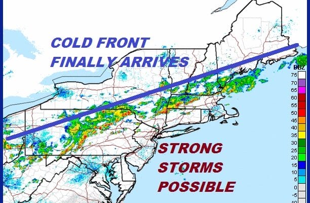
We are beginning to see thunderstorms firing up across Upstate NY and back in Western Pennsylvania. This is the cold front we have been waiting for to finally break the back of this week’s heat and humidity. No doubt some strong to possibly severe thunderstorms will occur from this frontal line and some should be getting close as we move through the evening commute. Thunderstorms should weaken after 9 or 10 pm as the front pushes east but there will certainly be some lightning displays, heavy rains and gusty winds.
EASTERN SATELLITE

REGIONAL RADAR

The local radars are beginning to pick up on the thunderstorm activity as well. The first band moves well to the north on the NYC radar but we are starting to see development on the Mount Holly radar.
LOCAL RADAR NEW YORK CITY

LOCAL RADAR PHILADELPHIA


There really isn’t much change in the outlook for Friday through Monday. The front will slow down on Friday as northeast winds start to kick in and cooler air begins to arrive. Some showers are possible. Friday night into Saturday morning we are likely to see a period of rain as a wave goes by on the front. That should push the front a little further south and high pressure starts to build southward from Eastern Canada. Temperatures Saturday will be in the low to mid 70s as the rain moves out and we deal with leftover clouds. Sunday might not be too bad with clouds and perhaps some breaks of sun especially from NYC north and east. Temperatures Sunday will be nice and cool with a fresh northeast wind and highs just in the upper 60s and lower 70s.
Rain comes back later Sunday night and Monday as the front becomes a warm front starts to move northward. Highs Monday will be back into the 70s. Warm humid conditions will develop again Tuesday and Wednesday and this is due to a big upper high in the Atlantic building back northwestward into the Northeast. This is the upper high that will be steering Hurricane Florence and JOESTRADAMUS has more on the hurricane and the highly uncertain nature going forward.
MANY THANKS TO TROPICAL TIDBITS FOR THE USE OF MAPS
Please note that with regards to any tropical storms or hurricanes, should a storm be threatening, please consult your local National Weather Service office or your local government officials about what action you should be taking to protect life and property.
LATEST JOESTRADAMUS ON THE LONG RANGE


