Week Ahead Midweek Dry Before Next Storm System

Week Ahead Midweek Dry Before Next Storm System
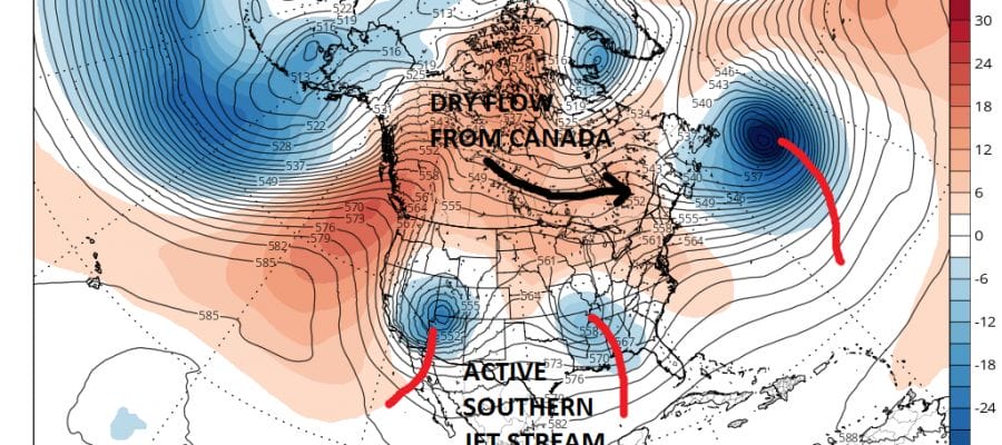
The weather pattern remains very active going forward as we continue to see the split flow in the upper air pattern bringing storm systems across the US and passing near and just to our south. In between dry air masses from Canada will keep things dry for a couple of days in between. We have to get rid of tomorrow’s system first. All through this will be the cold front/warm front battles and dealing with a northeast flow of cold marine air that will make things rather gray and gloomy at times.
The upper air pattern continues to be dominated by a “split” flow or 2 distinct jet streams. As long as the two streams remain separate, no major storms will develop. The energy in the south is strong at times so we will have to watch each one to see what the outcome will be. For now things to be operating in normal late March early April pattern.

Tuesday’s weather system is relatively weak and there will be some showers to work through overnight and on Tuesday. Low pressure will pass near or just to our south so Tuesday the areas south of NYC will probably get to the 60s while areas to the north continue to struggle in the upper 40s to mid 50s. The rain is more nuisance than anything else and there will be some dry periods in between.
Wednesday and Thursday look dry and seasonal temperature wise with some sunshine. Thursday probably will be the best day of the week. Then it is on to Friday and Saturday when low pressure heads our way from the Ohio Valley.
WEEK AHEAD GFS FORECAST FRIDAY & SATURDAY

MANY THANKS TO TROPICAL TIDBITS FOR THE WONDERFUL USE OF THE MAPS

GET JOE A CIGAR IF YOU LIKE!
LANDSCAPE COMPANIES FOR YOUR SPRING SUMMER FALL NEEDS
LONG ISLAND ROCKLAND COUNTY Connecticut

![]()

ROCKLAND COUNTY TRI STATE SNOW REMOVAL JOHNSTOWN PA


FiOS1 News Weather Forecast For Long Island
FiOS1 News Weather Forecast For New Jersey
FiOS1 News Weather Forecast For Hudson Valley
NATIONAL WEATHER SERVICE SNOW FORECASTS
LATEST JOESTRADAMUS ON THE LONG RANGE
Weather App

Don’t be without Meteorologist Joe Cioffi’s weather app. It is really a meteorologist app because you get my forecasts and my analysis and not some automated computer generated forecast based on the GFS model. This is why your app forecast changes every 6 hours. It is model driven with no human input at all. It gives you an icon, a temperature and no insight whatsoever.
It is a complete weather app to suit your forecast needs. All the weather information you need is right on your phone. Android or I-phone, use it to keep track of all the latest weather information and forecasts. This weather app is also free of advertising so you don’t have to worry about security issues with your device. An accurate forecast and no worries that your device is being compromised.
Use it in conjunction with my website and my facebook and twitter and you have complete weather coverage of all the latest weather and the long range outlook. The website has been redone and upgraded. Its easy to use and everything is archived so you can see how well Joe does or doesn’t do when it comes to forecasts and outlooks.
Just click on the google play button or the apple store button on the sidebar for my app which is on My Weather Concierge. Download the app for free. Subscribe to my forecasts on an ad free environment for just 99 cents a month.
Get my forecasts in the palm of your hand for less than the cost of a cup of Joe!
![]()
