
Weather Week Ahead Changes Coming Pattern Change
SHOP THE JOESTRADAMUS STORE
Weather Week Ahead Changes Coming Pattern Change
A slow moving upper air disturbance is moving offshore this evening and while there are still some clouds around we should see gradual clearing set in shortly and skies should clear everywhere overnight. Temperatures won’t fall too far tonight as we settle in the 30s to near 40 in the warmer urban areas. Inland where skies clear out faster some cold spots will see temperatures bottom in the 20s.
WEATHER WEEK AHEAD MONDAY FORECAST HIGHS
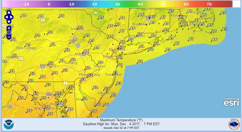
The satellite loop does show dry air just to the west so this should give us a nice day on Monday with plenty of sunshine and highs reaching into the 50s everywhere.
SATELLITE LOOP

REGIONAL RADAR

Tuesday begins the road to change with a cold front approaching. Lots of clouds are forecast for Tuesday with a few scattered showers that will become more numerous late in the day and Tuesday night into Wednesday morning. The bulk of the rain will be done by daybreak. In areas well north and west of the coast we could see sleet and snow mix in at the end but it won’t amount to much. Wednesday temperatures will start the day in the 50s and then drop through the 40s as colder air moves in. Some sunshine should develop through the leftover clouds. Thursday will be dry with some sunshine and highs just in the upper 30s and lower 40s.
WEATHER WEEK AHEAD GFS MODEL FRIDAY FORECAST

The front that moves through Wednesday stalls off the East coast and a wave is forecast to develop on it. Weather models continue to go back and forth on whether we will see any precipitation from this. For now we will forecast the chance for a cold rain near the immediate coast which could mix with some sleet or wet snow and the chance for rain or wet snow inland. Temperatures Friday will be in the 30s to near 40. Waves like this are always tough to figure as models want to push the front out but are indecisive as to how far east it gets. The overall pattern will be cold beginning on Wednesday and last into mid month. The pattern is also very dynamic and there will probably be several chances for snow along the way.
 GET JOE A CIGAR IF YOU LIKE

FiOS1 News Weather Forecast For Long Island
FiOS1 News Weather Forecast For New Jersey
FiOS1 News Weather Forecast For Hudson Valley


