Weather Models Severe Weather Threat

Weather Models Severe Weather Threat
No Issues Saturday
Heavy Rain Severe Thunderstorms Possible Sunday
Looking at the satellite loop this evening we can see dying clouds and showers over us now as a cold front moves through and weakens. Nothing more than a few sprinkles should be around this evening and then it is leftover clouds for the overnight into Saturday morning with temperatures in the 60s. Meanwhile in the Middle Mississippi Valley we have a long stream of tropical moisture with showers and thunderstorms. We can also see a twisting motion in the Northern Plains which is with a strong upper air disturbance that is dropping southeastward. The table is being set for a round of heavy rain and severe weather for Sunday. But at least Saturday looks good with a mix of sun and clouds and highs in the mid 70s coast to middle 80s inland.
Weather Models Severe Weather Threat Satellite Loops


You can see on the radar how minimal the activity is tonight. Anything that pops up on Saturday should be isolated in nature.
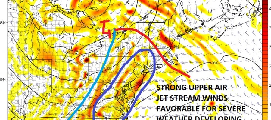
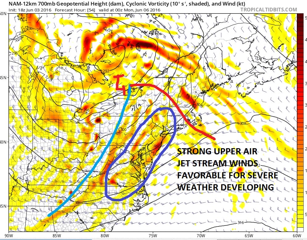
Sunday is a different story as the warm sector sets up along the Middle Atlantic Coast northeastward to Southern New England. The upper air is strongly suggesting severe weather with the greatest risk probably from Eastern Virginia northeastward into Southern New Jersey where the Storm Prediction Center is calling for the possibility of some super cell formation. The upper air map below shows a strong jet stream streak inside the blue circle which would be a severe weather indicator. The biggest question is how the warm sector sets up. This will drive the severe weather threat for Long Island and Connecticut which often times can be out of the prime formation area.
Weather Models Severe Weather Threat
UPPER AIR SUNDAY EVENING
This would be for later in the day Sunday into Sunday night. Before that there will be a round of rain late Saturday night into Sunday morning that could produce some locally heavy rains in some areas. There should be a short break in between the first shot of rain and the late day and evening thunderstorms.
Weather conditions should improve on Monday with a mix of sun and clouds, a gusty wind and temperatures reaching into the 80s.
LATEST WEATHER VIDEO MODEL ANALYSIS ON SEVERE WEATHER THREAT AND TROPICAL STORM DEVELOPING IN THE GULF OF MEXICO NEXT WEEK
JOESTRADAMUS HURRICANE SEASON GUEST FORECAST
FiOS1 News Weather Forecast For Long Island
FiOS1 News Weather Forecast For New Jersey
FiOS1 News Weather Forecast For Hudson Valley
NATIONAL WEATHER SERVICE SNOW FORECASTS
LATEST JOESTRADAMUS ON THE LONG RANGE
Weather App

Don’t be without Meteorologist Joe Cioffi’s weather app. It is really a meteorologist app because you get my forecasts and my analysis and not some automated computer generated forecast based on the GFS model. This is why your app forecast changes every 6 hours. It is model driven with no human input at all. It gives you an icon, a temperature and no insight whatsoever.
It is a complete weather app to suit your forecast needs. All the weather information you need is right on your phone. Android or I-phone, use it to keep track of all the latest weather information and forecasts. This weather app is also free of advertising so you don’t have to worry about security issues with your device. An accurate forecast and no worries that your device is being compromised.
Use it in conjunction with my website and my facebook and twitter and you have complete weather coverage of all the latest weather and the long range outlook. The website has been redone and upgraded. Its easy to use and everything is archived so you can see how well Joe does or doesn’t do when it comes to forecasts and outlooks.
Just click on the google play button or the apple store button on the sidebar for my app which is on My Weather Concierge. Download the app for free. Subscribe to my forecasts on an ad free environment for just 99 cents a month.
Get my forecasts in the palm of your hand for less than the cost of a cup of Joe!
![]()
![]()

MENTION JOE CIOFFI AND GET A 5% DISCOUNT


