Weather Models Moving Toward Colder Pattern Long Range

Weather Models Moving Toward Colder Pattern Long Range
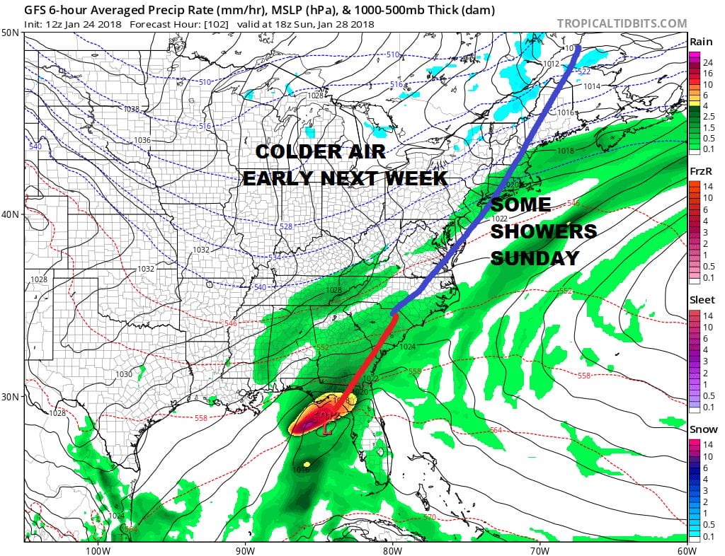
Weather models continue to move the chess pieces around and there are some more clues today pointing to a return to a colder pattern in the long range. However this may take another 10 days to 2 weeks to play out. In the meantime we continue to see a pattern of in and out cold air masses with cold fronts coming through from time to time with some showers. The first of these fronts arrives on Sunday with some rain showers ahead of it. High pressure is passing out to the southeast which will take the chill that is just returning today and Thursday to pull out with milder temperatures following for Saturday. Saturday will be the better of the two weekend days with some sunshine and highs reaching the upper 40s and lower 50s. We will get through some showers and mild temperatures on Sunday. The showers probably won’t amount to much. The wave in the Northeastern Gulf of Mexico will move northeast and should pass well to our south and east. What follows is another shot of cold air for the first part of next week.
WEATHER MODELS GFS SUNDAY 1PM
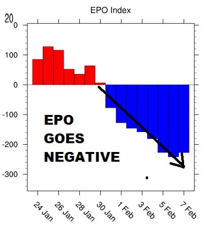
Monday into Wednesday temperatures will be a bit below average but not by much. Afterwards we begin what should be the grinding process of the upper air pattern readjusting. We continue to watch with interest the teleconnections as they will point the way forward. The East Pacific Oscillation is probably the most important regarding cold air. Today’s models show the EPO turning sharply negative and in fact today’s runs are more aggressive on the move down. The deeper into negative territory, the stronger and more dominant the cold pattern will be.
The EPO is important no doubt but the Pacific North America Index is probably more important for sustainability. Up until yesterday the PNA was forecast to be strongly negative however today’s run show the PNA spiking higher from deep negative to the neutral zone.
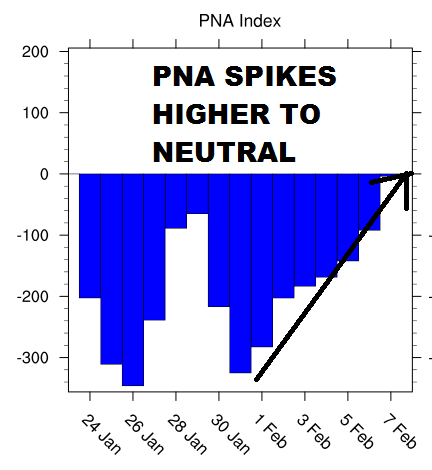
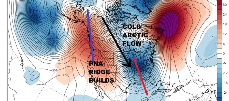
The spiking PNA index to neutral is because today’s models are showing a strong ridge beginning to build just inland of the West Coast rather then building offshore. This position is important in order to establish the connection in the flow from Northern Canada into the Eastern US.
WEATHER MODELS GFS JET STREAM MONDAY FEBRUARY 7
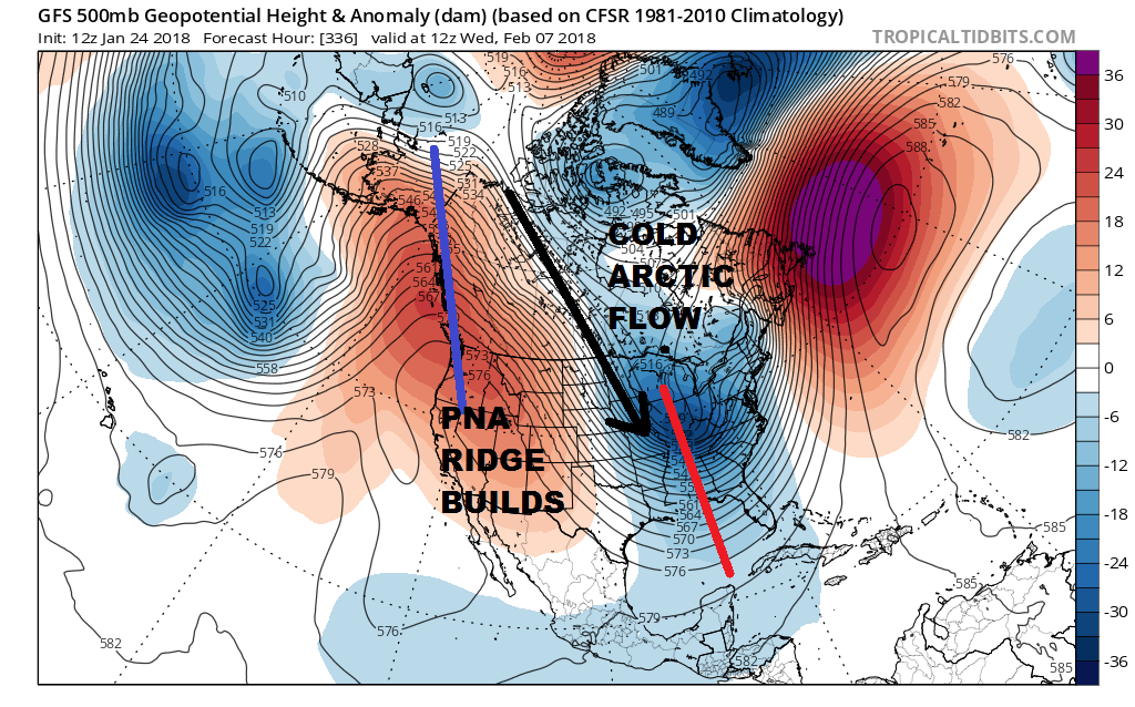
Going forward we will now have to see whether this trend continues in the coming days. We have a long way to go to get to this point and no doubt model runs will be doing their usual dance around the specifics. Other technical indicators point this happening. One key is the strong low that forms north of Hawaii which will force the ridge to build in the west. All of this makes for a very complex weather pattern going forward. As for snow in all of this, if this verifies I’m sure we will have some chances along the way.
MANY THANKS TO TROPICAL TIDBITS FOR THE WONDERFUL USE OF THE MAPS

GET JOE A CIGAR IF YOU LIKE!
FiOS1 News Weather Forecast For Long Island
FiOS1 News Weather Forecast For New Jersey
FiOS1 News Weather Forecast For Hudson Valley
NATIONAL WEATHER SERVICE SNOW FORECASTS
LATEST JOESTRADAMUS ON THE LONG RANGE
Weather App

Don’t be without Meteorologist Joe Cioffi’s weather app. It is really a meteorologist app because you get my forecasts and my analysis and not some automated computer generated forecast based on the GFS model. This is why your app forecast changes every 6 hours. It is model driven with no human input at all. It gives you an icon, a temperature and no insight whatsoever.
It is a complete weather app to suit your forecast needs. All the weather information you need is right on your phone. Android or I-phone, use it to keep track of all the latest weather information and forecasts. This weather app is also free of advertising so you don’t have to worry about security issues with your device. An accurate forecast and no worries that your device is being compromised.
Use it in conjunction with my website and my facebook and twitter and you have complete weather coverage of all the latest weather and the long range outlook. The website has been redone and upgraded. Its easy to use and everything is archived so you can see how well Joe does or doesn’t do when it comes to forecasts and outlooks.
Just click on the google play button or the apple store button on the sidebar for my app which is on My Weather Concierge. Download the app for free. Subscribe to my forecasts on an ad free environment for just 99 cents a month.
Get my forecasts in the palm of your hand for less than the cost of a cup of Joe!