Weather Models Monday Clipper System
Weather Models Monday Clipper System
We have been watching the possibility of a clipper system coming down from the Northern Great Lakes and redeveloping off the Delmarva Peninsula on Monday. Hints began yesterday on the models and the NAM model is the first to pick up on this on this morning’s run.
WEATHER MODELS NAM MODEL SUNDAY EVENING UPPER AIR
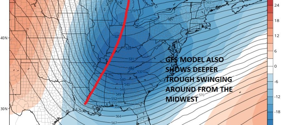
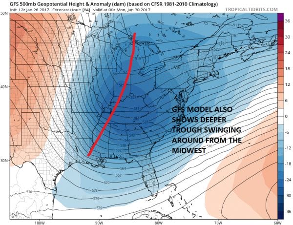
 The biggest issue regarding this look is the question of room. Earlier model runs had too much energy spread out over the Great Lakes and northeast leaving little room for anything to happen. Now models open up some room as the lead system in the Northeast on Sunday moves out faster and weaker which allows room for the next diving system to start carving a trough out deeper and further west.
WEATHER MODELS GFS UPPER AIR SUNDAY EVENING
WEATHER MODELS GFS SURFACE SUNDAY INTO TUESDAY MORNING
CLICK TO ANIMATE
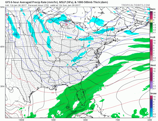 The surface map shows a dying low in the Eastern Great Lakes and a secondary low forming east of the Delmarva Peninsula. The GFS model has enough development that it would produce a coating to a few inches of snow from Northeastern Virginia to Southern New England.
WEATHER MODELS GFS SNOW FORECAST MONDAY INTO TUESDAY
 There are two important variables here. The first is that the lead system moving through the Northeast Sunday is indeed weaker and faster. Secondly there is another clipper behind this one that the European model and the Canadian model do something with Tuesday night and Wednesday. This would probably need to be a little weaker and a little slower which would give the Monday system room to play with. We are at the beginning of the looking stage here so let’s see where models go from here.
MANY THANKS TO TROPICAL TIDBITS FOR THE WONDERFUL USE OF THE MAPS
SNOW REMOVAL COMPANIES FOR YOUR WINTER NEEDS
LONG ISLAND ROCKLAND COUNTY Connecticut
ROCKLAND COUNTY TRI STATE SNOW REMOVAL JOHNSTOWN PA
FiOS1 News Weather Forecast For Long Island
FiOS1 News Weather Forecast For New Jersey
FiOS1 News Weather Forecast For Hudson Valley
NATIONAL WEATHER SERVICE SNOW FORECASTS
LATEST JOESTRADAMUS ON THE LONG RANGE
Weather App
Don’t be without Meteorologist Joe Cioffi’s weather app. It is really a meteorologist app because you get my forecasts and my analysis and not some automated computer generated forecast based on the GFS model. This is why your app forecast changes every 6 hours. It is model driven with no human input at all. It gives you an icon, a temperature and no insight whatsoever.
It is a complete weather app to suit your forecast needs. All the weather information you need is right on your phone. Android or I-phone, use it to keep track of all the latest weather information and forecasts. This weather app is also free of advertising so you don’t have to worry about security issues with your device. An accurate forecast and no worries that your device is being compromised.
Use it in conjunction with my website and my facebook and twitter and you have complete weather coverage of all the latest weather and the long range outlook. The website has been redone and upgraded. Its easy to use and everything is archived so you can see how well Joe does or doesn’t do when it comes to forecasts and outlooks.
Just click on the google play button or the apple store button on the sidebar for my app which is on My Weather Concierge. Download the app for free. Subscribe to my forecasts on an ad free environment for just 99 cents a month.
Get my forecasts in the palm of your hand for less than the cost of a cup of Joe!

