Weather Models Grow Bullish On Rain

Weather Models Grow Bullish On Rain
2 to 4 Inches Forecast
Overnight weather models continue the bullish trend for rainfall this week with what now appears to be 3 shots of rain as 3 waves of low pressure effect the east coast. Each wave that goes by swings a cold front closer to the coastline until the last one on Thursday goes by and brings the rain to a close by days end. At least this is the view of the GFS Canadian & European models.
Weather Models GFS Tuesday through Thursday Click To Animate

What would be nice is if models just simply perform in line with guidance as far as rainfall is concerned. This rainfall goes up and down the coast which means that not only drought areas get rain but fire ravaged Carolinas and Georgia get rain as well.
GFS RAINFALL FORECAST THROUGH FRIDAY
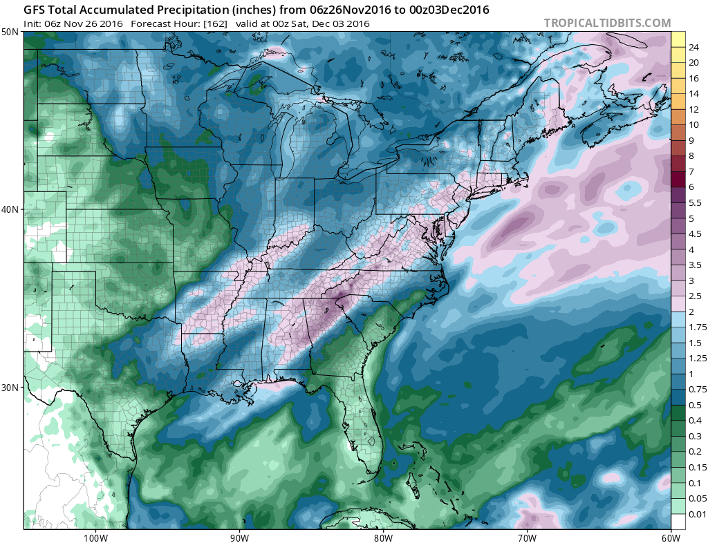
The GFS weather model has 2 to 4 inch rains total and the European and Canadian weather models are the same with the Canadian actually showing more. Given the fact that the Gulf of Mexico opens with some moisture and the deep trough that is swinging around in the upper air, the odds of this taking place are increasing. Rain will begin on Tuesday and last through Thursday with 2 breaks in between. Until then weather conditions slowly improve this weekend with increasing amounts of sun especially on Sunday and dry Monday with temperatures both days in the 40s.
MANY THANKS TO TROPICAL TIDBITS FOR THE WONDERFUL USE OF THE MAPS
SNOW REMOVAL COMPANIES FOR YOUR WINTER NEEDS
LONG ISLAND ROCKLAND COUNTY Connecticut

![]()


WINTER 2016-2017 PART 1 OCEAN WATER TEMPERATURES
WINTER 2016-2017 PART 2 ARCTIC SEA ICE AND SIBERIAN SNOW COVER
FiOS1 News Weather Forecast For Long Island
FiOS1 News Weather Forecast For New Jersey
FiOS1 News Weather Forecast For Hudson Valley
NATIONAL WEATHER SERVICE SNOW FORECASTS
LATEST JOESTRADAMUS ON THE LONG RANGE
Weather App

Don’t be without Meteorologist Joe Cioffi’s weather app. It is really a meteorologist app because you get my forecasts and my analysis and not some automated computer generated forecast based on the GFS model. This is why your app forecast changes every 6 hours. It is model driven with no human input at all. It gives you an icon, a temperature and no insight whatsoever.
It is a complete weather app to suit your forecast needs. All the weather information you need is right on your phone. Android or I-phone, use it to keep track of all the latest weather information and forecasts. This weather app is also free of advertising so you don’t have to worry about security issues with your device. An accurate forecast and no worries that your device is being compromised.
Use it in conjunction with my website and my facebook and twitter and you have complete weather coverage of all the latest weather and the long range outlook. The website has been redone and upgraded. Its easy to use and everything is archived so you can see how well Joe does or doesn’t do when it comes to forecasts and outlooks.
Just click on the google play button or the apple store button on the sidebar for my app which is on My Weather Concierge. Download the app for free. Subscribe to my forecasts on an ad free environment for just 99 cents a month.
Get my forecasts in the palm of your hand for less than the cost of a cup of Joe!
![]()
