
Weather Models Breaking Block With Coastal Storm This Weekend
Weather Models Breaking Block With Coastal Storm This Weekend
We are beginning to see signs of the block breaking down and weather models accelerate the process over the coming days. Often times when this happens we get some sort of storm development somewhere. It seems the Middle Atlantic and Northeast will be the ones to see it in the form of a fast and not so usual mid May noreaster for Saturday night into Sunday morning. The satellite loop shows the large upper low leftover from last Friday’s heavy rain churning along the New England coast. Clouds to the northeast of that are moving southwestward in response to a blocking high over Greenland and a strong storm over the Azores. It is a complex surface and upper air pattern. But with that block breaking down it opens the door for low pressure now in the Southwest to head for the East coast for the weekend.
GFS MODEL SHOWS GALES WITH LOW PRESSURE NEAR MONTAUK
SUNDAY MORNING

Much like the last several days clouds are rotating through this evening but we should go clear overnight at some point with lows in the 40s. Thursday I think will be partly sunny much like today with highs in the 50s along the coast and low to mid 60s inland.
SATELLITE LOOP

REGIONAL RADAR

LOCAL RADAR NEW YORK CITY

LOCAL RADAR PHILADELPHIA


Friday look for sunshine to give way to arriving clouds from both the east and the west as low pressure begins it approach. The rain for Saturday will develop from south to north during the morning with the heaviest rains moving up later in the afternoon into Saturday night. Areas to the south of NYC will see the rains end probably by daybreak or sooner while areas to the north and east will rain for awhile longer.
GFS RAINFALL FORECAST FROM NOREASTER
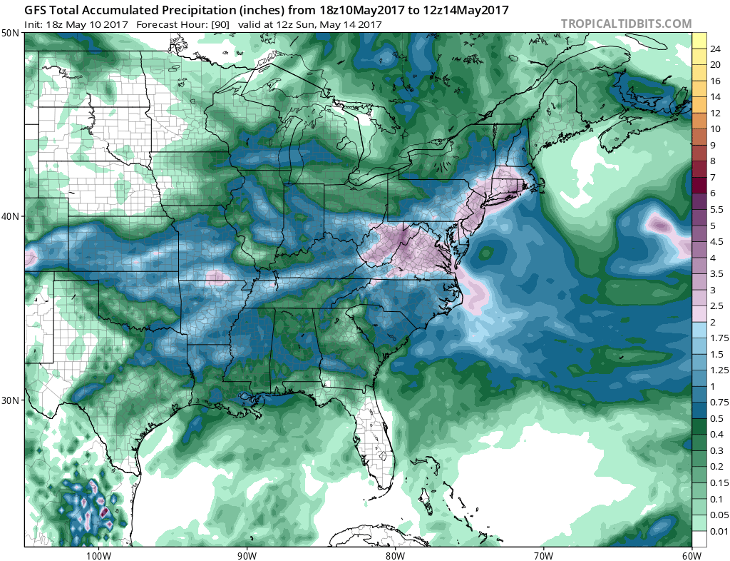
Weather models continue to grow more bullish on rainfall amounts with the new GFS even more aggressive than the prior two runs…and those runs were aggressive. The map would show 4 inch plus amounts possible. I’m not ready to sign off on this but the upper air certainly does support a solid couple of inches in most places. Needless to say that if this pans out, whatever is left of the drought will be completely wiped out.
 GET JOE A CIGAR IF YOU LIKE

LANDSCAPE COMPANIES FOR YOUR NEEDS
LONG ISLAND ROCKLAND COUNTY Connecticut

![]()

ROCKLAND COUNTY TRI STATE SNOW REMOVAL JOHNSTOWN PA


FiOS1 News Weather Forecast For Long Island
FiOS1 News Weather Forecast For New Jersey
FiOS1 News Weather Forecast For Hudson Valley
NATIONAL WEATHER SERVICE SNOW FORECASTS
LATEST JOESTRADAMUS ON THE LONG RANGE
Weather App

Don’t be without Meteorologist Joe Cioffi’s weather app. It is really a meteorologist app because you get my forecasts and my analysis and not some automated computer generated forecast based on the GFS model. This is why your app forecast changes every 6 hours. It is model driven with no human input at all. It gives you an icon, a temperature and no insight whatsoever.
It is a complete weather app to suit your forecast needs. All the weather information you need is right on your phone. Android or I-phone, use it to keep track of all the latest weather information and forecasts. This weather app is also free of advertising so you don’t have to worry about security issues with your device. An accurate forecast and no worries that your device is being compromised.
Use it in conjunction with my website and my facebook and twitter and you have complete weather coverage of all the latest weather and the long range outlook. The website has been redone and upgraded. Its easy to use and everything is archived so you can see how well Joe does or doesn’t do when it comes to forecasts and outlooks.
Just click on the google play button or the apple store button on the sidebar for my app which is on My Weather Concierge. Download the app for free. Subscribe to my forecasts on an ad free environment for just 99 cents a month.
Get my forecasts in the palm of your hand for less than the cost of a cup of Joe!


