
Flooding Risk High This Weekend

Flooding Risk High This Weekend
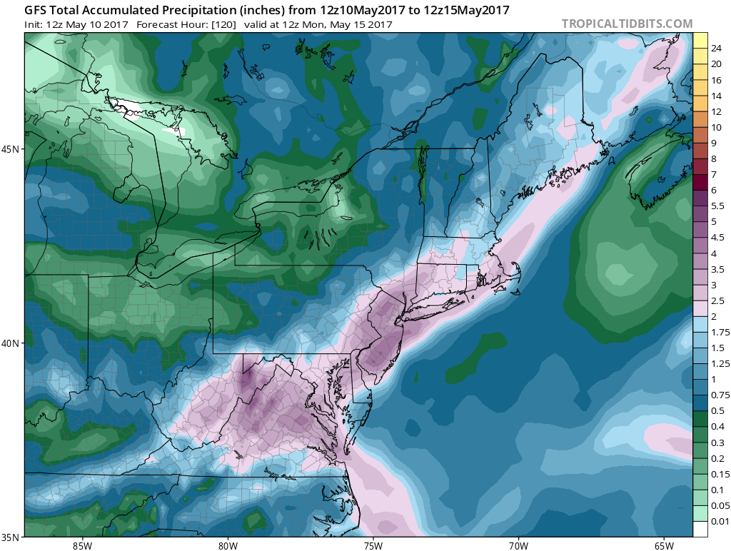
We continue to look at the weekend weather system as weather models are all lining up for a heavy rain event. The GFS model is the most bullish with rainfall amounts showing a widespread 2 to 4 inch rainfall for Saturday into Sunday morning. The heaviest rain will fall Saturday night. Certainly if these numbers verify there will be flooding issues when you wake up Sunday morning.
FLOODING RISK HIGH GFS RAINFALL AMOUNTS
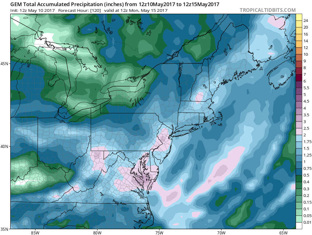
The GFS maintains a well defined feature at mid levels of the atmosphere and shows a very strong inflow from off the ocean as low pressure develops along the New Jersey coast. Other models are a little less robust but the Canadian and European model do show 1 to 3 inch rain amounts are possible.
FLOODING RISK CANADIAN MODEL TOTAL RAINFALL
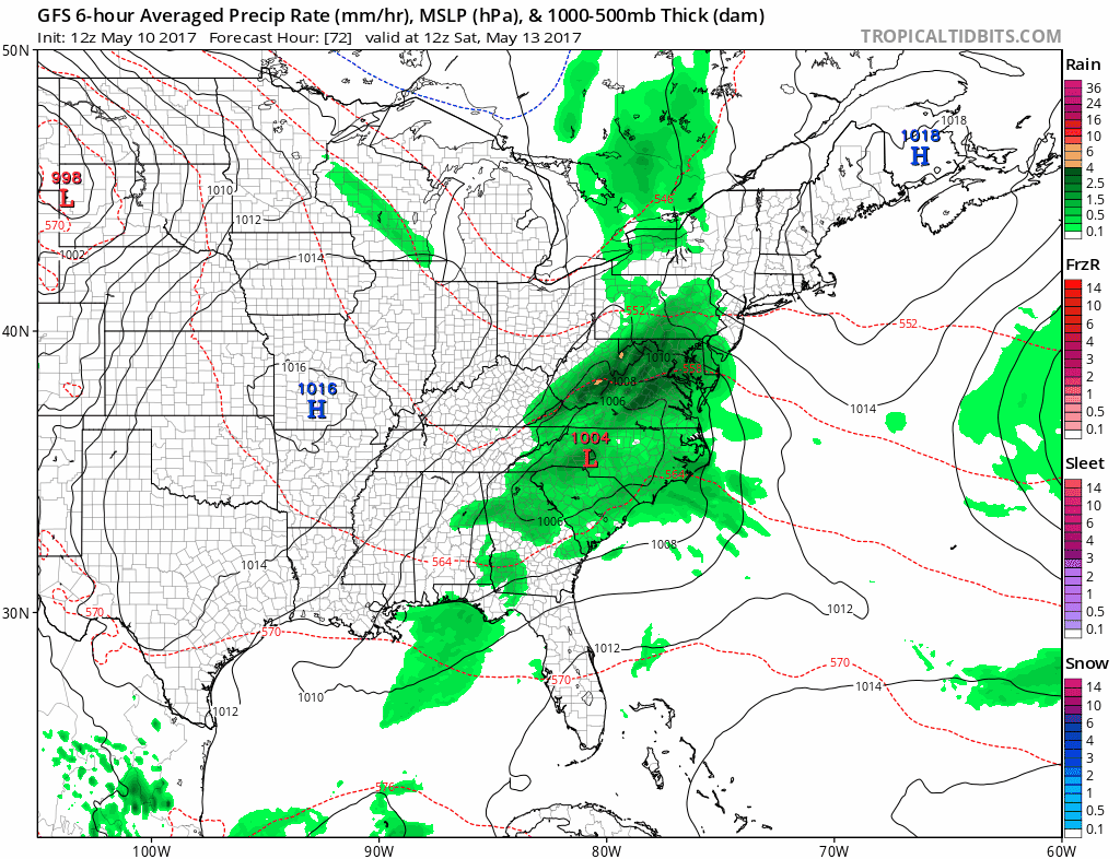
Given that we are no longer in a drought and rivers and streams have returned to their normal levels it would not be a surprise to see a flooding risk from this weather system. Rain will move in from south to north during Saturday morning. with the heaviest rain developing later Saturday afternoon and moving south to north Saturday night into Sunday morning.
FLOODING RISK GFS SATURDAY MORNING INTO SUNDAY EVENING
The breaking down of the block would argue for this weather system to move along so there is a fair chance that we could see slowly improving weather conditions from south to north on Sunday, Mother’s Day, however i would look for the rain to linger into the afternoon across Connecticut and Long Island especially as you go east…while areas to the west like Western and South Jersey and Eastern Pennsylvania could see improvement faster with the rain done before daybreak Sunday. Once this system is done it looks like next week we will return to a more normal pattern for May which is for weather systems to move west to east on a regular basis. This should allow temperatures to warm up into the 70s for a few days (depending on wind direction). Monday and Tuesday look dry with some sunshine both days.
MANY THANKS TO TROPICAL TIDBITS FOR THE WONDERFUL USE OF THE MAPS

GET JOE A CIGAR IF YOU LIKE!
LANDSCAPE COMPANIES FOR YOUR SPRING SUMMER FALL NEEDS
LONG ISLAND ROCKLAND COUNTY Connecticut

![]()

ROCKLAND COUNTY TRI STATE SNOW REMOVAL JOHNSTOWN PA


FiOS1 News Weather Forecast For Long Island
FiOS1 News Weather Forecast For New Jersey
FiOS1 News Weather Forecast For Hudson Valley
NATIONAL WEATHER SERVICE SNOW FORECASTS
LATEST JOESTRADAMUS ON THE LONG RANGE
Weather App

Don’t be without Meteorologist Joe Cioffi’s weather app. It is really a meteorologist app because you get my forecasts and my analysis and not some automated computer generated forecast based on the GFS model. This is why your app forecast changes every 6 hours. It is model driven with no human input at all. It gives you an icon, a temperature and no insight whatsoever.
It is a complete weather app to suit your forecast needs. All the weather information you need is right on your phone. Android or I-phone, use it to keep track of all the latest weather information and forecasts. This weather app is also free of advertising so you don’t have to worry about security issues with your device. An accurate forecast and no worries that your device is being compromised.
Use it in conjunction with my website and my facebook and twitter and you have complete weather coverage of all the latest weather and the long range outlook. The website has been redone and upgraded. Its easy to use and everything is archived so you can see how well Joe does or doesn’t do when it comes to forecasts and outlooks.
Just click on the google play button or the apple store button on the sidebar for my app which is on My Weather Concierge. Download the app for free. Subscribe to my forecasts on an ad free environment for just 99 cents a month.
Get my forecasts in the palm of your hand for less than the cost of a cup of Joe!
![]()
